Manual Explotación de la Red Vial
& Sistemas Inteligentes de Transporte
Guía para profesionales!

Manual Explotación de la Red Vial
& Sistemas Inteligentes de Transporte
Guía para profesionales!
Software and relational databases are required for ITS technologies to store, manage and archive network data. These are brought together as Archived Data Management Systems (ADMS) or what is sometimes called ITS Data Warehouses. ADMS offers an opportunity to take full advantage of the travel-related data collected by ITS devices in improving transport operations, planning and decision-making at minimal additional cost.
The technologies supporting ADMS are designed to archive, fuse, organise and analyse ITS data and can support a wide range of very useful applications such as:
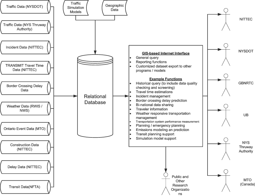
The figure below shows an example of the system architecture designed for a simple ITS Data Warehouse being developed for the Buffalo-Niagara region in New York State USA. At the core of the system is a relational data base (such as Oracle or MySQL) which receives data from a wide range of sources including real-time traffic data (volumes, occupancies and speed), incident information, travel time and delay information, weather data, construction and work-zone information, and transit data (such as automatic vehicle location data). The relational database organises and fuses the data and information together – linking the different data streams through common identifiers – allowing a wide range of applications to be developed and deployed.

Among the data stored in ADMS are transport system inventory data, which can be used to facilitate the construction of detailed network models and traffic simulation models. Every link and associated junction in the network will need to be classified according to its strategic importance and capacity. Many ADMS are provided with functionalities that can convert the stored data into the required format for running different traffic simulation and analysis software.
A key benefit of having an ADMS is the ability to quantify network conditions in terms of travel times, speeds and traffic volumes. These measures, based on real-time traffic data, can be used to provide dynamic status information of prevailing network conditions and the “level of service” offered to road-users. Historical data of this kind, including information for incident detection and management and for traffic modelling, can also provide the basis for traffic forecasting and predictive information.
Tree-building algorithms:
Almost all ADMS now include a web-based graphical interface to support users’ queries. The interface is commonly based on Geographic Information Systems (GIS) technology. GIS comprise a set of computer software, hardware, data, and personnel – that store, manipulate, analyse, and present geographically referenced (or spatial) data. GIS can link spatial information on maps (such as roadway alignment) with attribute or tabular data. For example, a GIS-digital map of a road network would be linked to an attribute table that stores information about each road section on the network. This information could include items such as the section ID number, length of section, number of lanes, condition of the pavement surface, or average daily traffic volume. By accessing a specific road segment, a complete array of relevant attribute data becomes available.
The Graphical User Interface (GUI) shown in the ADMS architecture diagram above shows that the data archived in the ADMS can be accessed by different stakeholders over the Internet. Custom applications and reporting functions may be designed including performance measurement, predictive traveller information, traffic simulation model development support, and many other applications.