Tokyo, Japan – Delivery operations
Intelligent Transport Systems can enable a very wide range of user servcies:
Moving people and freight seamlessly is at the heart of efficient transport services and operations. The challenge is to meet the demand for transport in a way that is sustainable. The application of proven technologies to services that support efficient, clean, safe, attractive, and competitive transport operations provides a number of cost effective solutions.
The potential for added value services is as broad as the problems they need to address – whether it is fleet management, electronic ticketing, security screening or anything else.
Electronic Payment Systems (EPS) are now widely used for a variety of transport applications. For example:
EPS offers major advantages over cash payment:
EPS already plays an important part in the development of integrated transport policies (See Policy Framework Analysis). The planning of individual EPS schemes requires:
The harmonisation and interoperability of electronic payment systems can support the development of multi-modal, integrated transport – but there are significant challenges in integrating payment systems and data exchange between separate organisations. Essential factors that need to be addressed when implementing EPS across multiple services include:
All EPS require efficient and effective Back-Office arrangements to:
EPS is a powerful way of introducing travel demand management and other transport, social and environmental policy objectives – such as selective charging of HGVs which cause disproportionate damage to the roads compared to other vehicles. In the long-term, as public acceptance of EPS grows, its use could be extended to other areas. For example EPS could be used to replace taxes on vehicle ownership and usage (such as fuel tax) with charges that vary according to the time, distance travelled and the places where a vehicle is driven (See Future Trends). Videos: How Electronic Tolling Works and Interoperable Electronic Toll Collection( ETC) on NH-8
Electronic Payment Systems (EPS) provide a convenient, secure and auditable means of paying for different transport services and offer major advantages over cash payment for transport and highway operators, their passengers and customers, including:
Electronic payment benefits travellers and operators whilst speeding up the payment process, improves the efficiency of payment processes that were formerly cash-based and provides convenience for users of public transport. Electronic payment enables new business models, for example Electronic Toll Collection (ETC) no longer has to be considered as a means of improving efficiencies at toll plazas alongside cash and card-paying customers, but instead toll roads can now be designed exclusively for ETC operation, eliminating the need for toll plazas and allowing vehicles to pay tolls without having to slow down or stop.
Electronic payment applications are enabled by a variety of technologies including smart cards, RF tags and mobile phones. The principal applications are as follows:
Videos: How Electronic Tolling Works & Interoperable Electronic Toll Collection( ETC) on NH-8
The reason why a route may be tolled is most often to recover some or all of the costs of construction, operation and maintenance of roads, bridges, and tunnels. Tolls collected are:
Part of the revenue collection process can be automated to improve operating efficiencies and reduce the operating cost of toll collection by means of Electronic Toll Collection (ETC). Prior to the introduction of ETC tolls were collected manually – involving the construction of large “toll plazas” on motorways with multiple toll booths.
ETC is now an established means of payment for road usage – and ETC may be offered alongside cash and cards at a toll plaza. When a high proportion of vehicles are equipped for electronic payment, it is feasible to provide ETC as the only means of payment – in which case, toll plazas may not be required at all.
ETC needs to be supported by an adequate legal framework and enforcement processes. It may make use of:
To be efficient, a toll collection facility should accept several Means of Payment (MOP), including cash and credit cards. Toll plazas may be used as an effective means of regulating vehicle flow to ensure that the drivers of all vehicles provide a valid payment or provide some evidence that they are exempt from tolls. Since its first commercial application in October 1987, ETC has been accepted worldwide as an additional means of payment since it is a highly reliable, efficient and accurate way of tolling that offers convenience since drivers do not have to stop to pay. ETC also provides a higher throughput compared to other means of payment. ETC is found in almost every country with a mature road network such as Australia, China, Colombia, France, India, Mozambique, Norway, South Africa, Spain and the US, amongst many others. Video: Interoperable Electronic Toll Collection( ETC) on NH-8
Typically, the technologies for ETC include vehicle detection, classification and some form of account identification such as:
As vehicle demand increases, the capacity of a toll plaza must also increase – either by adding new toll lanes or by increasing the throughput of existing lanes. This can be done by adding ETC capability with incentive discounts. Ideally the ETC will be interoperable with other toll collection facilities to:
As demand increases yet further – or if there are constraints on land usage for toll plazas – it may be necessary to consider implementing Multi-lane Free-flow (MLFF) tolling which reduces or removes completely the requirement for toll plazas. MLFF will increase the speed and volume of vehicle throughput but requires robust enforcement mechanisms. Video: Gantry installation at the Dartford Crossing - time-lapse

Plaza-based Electronic Toll Collection, Taiwan

Multi-Lane Free Flow Electronic Toll Collection, South Africa
Toll collection is a highly standardised process. Using ETC it can be automated to improve operational efficiency and minimise the cost of processing every vehicle passage. For drivers to experience the benefits of non-stop payment of tolls, a sufficient number of lanes need to be equipped with vehicle detection and classification technology and ETC readers, supported by an enforcement system (See Back Office/Enforcement). As demand increases more lanes on each toll plaza can be equipped with ETC. Some lanes can offer multiple Means of Payment (MOP) – manual and ETC with other lanes dedicated to ETC only.
Where it is not possible to create space for a toll plaza (for example, in an urban environment or where it is not practical to disrupt the flow of traffic on an existing motorway), Multi-lane Free Flow (MLFF) tolling may be used. This:
In all cases, if compliance checks fail, enforcement is necessary using the images captured by the cameras (See Back Office/Enforcement). To maximise accessibility, users that still wish to pay by cash or credit card may be given the option of paying at retail outlets or via the Internet. Similarly occasional users may be able to register for a video tolling account – although a premium may be applied to reflect the additional cost of processing video images compared with more accurate, lower error tag-based transactions.
There are examples of MLFF systems in Australia, Canada, Chile, New Zealand and the US – with more recent introductions in China, Ireland and South Africa. Each of these uses either RFID or DSRC tags as the primary Means of Payment (MOP) and offer video tolling as a secondary solution.
Advances in satellite positioning mean that tolls can now be calculated based on the time, distance travelled or the location of the vehicle on the road network. These are measured using an On-board Unit (OBU) that has the capabilities to estimate its own position via Global Navigation Satellite System (GNSS) and to communicate this information over a Cellular Network (CN). A GNSS/CN-based scheme is an advanced method of tolling and is used in some countries for HGV tolling (See Heavy Good Vehicle Tolling).
ETC provides the opportunity to automatically link a vehicle with an account that is to be charged with the required tolls. This improvement in efficiency benefits road users and toll road operators by reducing congestion, reducing harmful emissions and improving throughput. The tolling policy, security issues, construction and operating costs and other constraints such as the availability of land will determine which is the most appropriate deployment strategy and technology to use:
As the usage of ETC increases, the need to collect payments in cash reduces. The cost of investing in ETC systems is high. Inevitably, there will be improvements in technology over time (for example, mobile phone payment, contactless payment cards) with the risk that that a tolling solution may be overtaken. Improvements in performance and reductions in cost (particularly of tags and On-Board Units) may offer long-term operational benefits – to the extent that an upgrade may need to be considered.
Procuring RFID or DSRC systems that comply with standards make it easier to have a broader choice of suppliers and avoid “technology lock-in”. A periodic review of technology options will help to inform the scope and potential cost of a replacement system or upgrade to the current technologies.
From an operational perspective, it may be a good idea to move away from each toll operator maintaining its own back-office. A separation of ETC account management from other aspects of tolling operations – as demonstrated in Europe (Ireland) – can encourage the emergence of specialised back-office support able to service a number of different operators, with corresponding efficiency savings (See Standardisation & Interoperability).
ETC has been proven to be a viable means of automating toll collection in developed and developing economies. If cash payments for tolls are an accepted form of payment en-route, a toll plaza is needed. These can offer a range of Methods of Payment (MOP), including ETC. The enforcement strategy could include a barrier or a traffic light that prompts road users to present a valid MOP on entry to, or exit from, a tolled route (See Back Office/Enforcement).
For occasional users, video tolling could be offered. Where an accurate national register of vehicles exists, it becomes possible to operate toll lanes without barriers – since the register enables association of a vehicle and its number plate with a specific person or company. Instead of barriers, cameras can be used to capture images of evidential-quality to prove that the vehicle was present for enforcement purposes.
If the public acceptability for tolls is low, and the risk of payment evasion is high – a barrier to control the flow of vehicles is likely to be the most practical option, even if an accurate vehicle register exists.
A Heavy Goods Vehicle (HGV) is more likely to travel longer distances than a light goods vehicle – in some cases crossing borders and travelling through countries to reach distant customers. Tolling of heavy goods vehicles is aimed at regulating their use of roads. It helps ensure that HGVs pay a contribution towards the cost of providing and maintaining the road infrastructure they use – even if vehicles are registered in other countries. Taxes and charges are most commonly levied on the basis of distances travelled and annual permits. Its deployment may be limited to a strategic road network or apply to all roads.
The first use of taxing HGVs for distance travelled, was in New Zealand in 1975. Since then, the practical implementation of regulating HGVs use of roads by means of taxes and charges has evolved significantly and can be based on route and time of travel as well as distance travelled. The requirements for accuracy of charging and the enforceability of schemes have evolved to the point that HGV charging is now a proven ITS application – technically and operationally.
Globally, the densest networks of actively regulated HGVs are in the European Union – as illustrated in the figure below. This includes the UK, where the HGV levy was introduced in April 2014. Elsewhere in Europe, Switzerland and Norway have implemented schemes – and there are other examples in Australia, North America and sub-Saharan Africa. Transit nations such as Austria, Germany, Namibia and Switzerland have developed their own regulations based on some mix of road types, time and distance, with variations of charges depending on emissions class of the vehicle.
 (Source: European Commission)")
Charging of Heavy Goods Vehicles in the EU (as of 2015) Source: European Commission
HGV tolling does not depend on the existence of a general ETC tolling regime for all vehicles – but can make use of it.
Most commonly, an HGV tolling policy is stand-alone (such as in Austria, Germany, Namibia and Switzerland) – but where part of the road network already imposes tolls on all vehicles, HGV tolling can be integrated into a general tolling policy (such as in the USA). The tolling policy defines the operational strategy and technology requirements. In all cases, there needs to be:
HGV tolling can be achieved by:
The relatively low cost of tags and roadside identification systems suits an HGV scheme that has a very limited number of roads or border crossings (See Methods of Payment). On Board Units (OBUs), able to determine vehicle location via Global Navigation Satellite Systems (GNSS) allow an HGV tolling scheme to be deployed on a much larger road network and enable differentiation of charges according to type of road or other factors.
The vehicle location technologies used in ETC also support other objectives – such as the management of HGVs conveying hazardous materials (‘Hazmat’), fleet management, cross-border pre-clearance, cabotage regulation, and detection and enforcement of overweight vehicles (See Freight and Commercial Services).
Charges may also vary according to a HGV’s emission class or other factors. Examples include:
The starting point of some of the HGV charging schemes (for example, Switzerland, Germany and the Czech Republic) was a paper ‘vignette’ (a time-based permit) that was displayed in the windscreen of vehicles that used the main road network. The labels are designed to be checked manually but some are not very secure since they can be modified or forged. The UK scheme uses the vehicle’s number plate to check whether a vignette has been paid (recorded on a central database) – rather than a paper sticker. Alternatively:
A back office is needed to manage the database of HGVs and enforcement operations (See Back Office/Enforcement). If charges are not related to usage, an annual charge can be levied on all HGVs (for example, the UK’s HGV Levy). Compliant vehicles can be confirmed by comparing vehicle number plates with a centrally held database of vehicles and payments made.
The cost and time to register HGVs for tolling should not be underestimated. It is recommended that sufficient vehicles are registered before HGV tolling commences – to reduce the initial strain on the enforcement operations. Compliance checking may always require some combination of mobile inspectors and unmanned, static roadside systems. Static systems can operate at lower cost with higher accuracy on busy roads compared with manual checks. Occasional users may be able to register manually for every trip (such as in Germany).
HGV tolling exists in many forms – from vignettes to GNSS-based schemes with static enforcement and mobile inspection teams. All European HGV tolling schemes that have migrated from a vignette system to HGV tolling have chosen DSRC, GNSS or some combination of these, supported by fixed and mobile enforcement. The unit cost of a GNSS-based OBU is higher than an RFID or DSRC tag – but the initial cost must be weighed against the cost of operations and the number and type of roads to be tolled.
Migration is feasible:
The adoption of standards or harmonisation of systems provides flexibility for migration – particularly in relation to the format of vehicle number plates and account details from tags and GNSS-based OBUs. Periodic monitoring of new technologies (and standards) to help plan for the long-term, is recommended.
Cross-border HGV movements bring their own challenges:
Various solutions exist:
NZ Transport Agency, 2013. Road User Charges, NZ Transport Agency, New Zealand Government
Swiss Federal Department of Finance (Switzerland): http://www.ezv.admin.ch/zollinfo_firmen/04020/04204/04208/
German LKW Maut scheme operator: http://www.toll-collect.de
Transport for London (UK): www.tfl.gov.uk/lez
Port of Los Angeles: http://www.portoflosangeles.org/ctp/ctp_portcheck.asp
Road Fund Administration (Namibia): http://www.rfanam.com.na
Pickford A. and Blythe P. (2006) Road User Charging and Electronic Toll Collection, Ch2, Artech House, Boston (USA) and London (UK)
New Zealand Government. Road User Charges Act, 1977.
Congestion charging, also known as ‘Congestion Pricing’ relies on charging to manage traffic demand in a congested area – for example, a Central Business District (CBD) and other well-defined area. The objective is to keep traffic demand under control with a balance between alternative transport modes. A major benefit for drivers is more consistent journey times (See Case Study – Congestion Charging).
Electronic charging for these purposes should be implemented in a way which minimises any wider negative impacts on other modes transporting people and goods through the congestion charge zone – since this could reduce economic activity within the zone.
Reducing traffic demand can free-up road capacity for reallocation to support other transport priorities – such as public transport (such as bus lanes), pedestrians (allowing longer green times at crossings) and cycling (dedicated or mixed-use facilities). This needs careful consideration and assessment of impacts since it can lead to unintended negative effects. For instance, any reallocation of the road space, reduces the residual space available to vehicles that have paid a congestion charge and could result in an increase in their journey time. This would be contrary to the initial objectives of the congestion charging policy.
Where the core policy is demand management – charges may be differentiated by congestion, vehicle type, time-of-day and other factors. Additional policies may include the reduction of emissions – in which case congestion charges will need to be differentiated by vehicle emissions as well.
The options for implementing congestion charging include:
Since congestion charging is usually introduced onto an existing road network, it needs to be accompanied by:
A congestion charge may be unpopular with road users although the level of support may increase once the benefits have been sufficiently demonstrated (such as in Stockholm). A successful policy needs to be:
The operational strategy must support these goals. The objectives must be realistic and achievable – and measures of performance reported publicly at frequent intervals to retain public support. Alternative approaches to achieving them could include:
The number of road users willing to pay a fee to access a route or area will vary with changing fee levels. This is known as the ‘Price Elasticity of Demand’ (PED). A low PED means that a variable pricing policy is less efficient:
The relationship between the speed of vehicles and the number of vehicles that pass a given point in an hour is known as a ‘backward bending curve’. It is illustrated in the speed-flow diagram below – and demonstrates that a reduction in demand (caused by imposing a fee) has the effect of increasing road capacity and speed. Since it is usually the peak load traffic that causes congestion, it doesn't necessarily require a huge traffic reduction to increase the traffic flow substantially. In light traffic, all vehicles can travel at similar speeds in free flow conditions but as the volume of traffic increases the speed decreases. As the traffic increases further, the speed and capacity both decrease until road users are stuck in congestion.

Speed–flow diagram, based on USDOT data
The relationship between price and demand is at the heart of the policy of congestion charging, as shown in Singapore, London (UK), Gothenburg and Stockholm (Sweden).

Figure 5: Roadside system - Congestion Tax, Stockholm, Sweden.
A vehicle may be identified by its number plate (read by one or more cameras) on entry to, and exit from, and within, a regulated area or defined route. Most commonly, reading a vehicle’s number plate will be sufficient to record a vehicle’s presence and to help match it with a payment (such as the systems in Stockholm and London). Alternatively:
Typically, compliance is based on a vehicle being fitted with a valid tag, OBU or a number plate that is associated with a pre-paid account.
Images of non-compliant vehicles may be used as evidence for enforcement purposes – although users may be given a short period of grace during which they can pay the charges before any penalties or legal processes are started. As with tolling (See Toll Collection), a back office and enforcement processes are necessary to ensure compliance, to deter non-compliance and to recover revenues (See Back Office/Enforcement).
Congestion charging must be implemented within a clear policy framework – bearing in mind that:
The technology options for charging and the operations strategy are defined by the congestion charging policy.
If the policy changes in the future – the technology and operations strategy may also need to change. For example, if a policy goal is to support increased use of low emission vehicles and discounts are provided on their use in the congestion charging zone - there must be some means of ensuring that only low emission vehicles receive the discount. This may require establishing a database of vehicles registered for the scheme and their emission classes.
Any congestion charging system must be planned so that it can be ‘scaled’ up in the future. The most common changes are likely to include variations in discounts offered, increasing the geographic area of the charging zone, enabling interoperability with other charging schemes (or tolled routes) – and the use of more tags or OBUs(See Standardisation & Interoperability Issues).
The alternative strategies to pricing as a demand management tool include:

Figure 6: Mixed traffic conditions, Delhi, India
US Federal Highways Administration, HERS-ST Highway Economic Requirements System - State Version: Technical Report, Appendix C Demand Elasticities for Highway Travel: http://www.fhwa.dot.gov/asset/hersst/pubs/tech/tech11.cfm
Land Transport Authority (Singapore): http://www.lta.gov.sg/content/ltaweb/en/roads-and-motoring/managing-traffic-and-congestion.html
Transport for London (UK): http://www.tfl.gov.uk/cc
Swedish Transport Agency (Sweden): http://www.transportstyrelsen.se/en/road/Congestion-tax/
Transport for London (2003) Impacts Monitoring – First Annual Report, Transport for London (http://www.tfl.gov.uk/assets/downloads/Impacts-monitoring-report1.pdf)
Pickford A. and Blythe P. (2006) Road User Charging and Electronic Toll Collection, Ch2, Artech House.
Smeed R. (1964) Road pricing: The Economic and Technical Possibilities. UK Ministry of Transport, HMSO, London.
Vickrey, W.S. (1969) Congestion Theory and Transport Investment. American Economic Review 59 (Papers and Proceedings) pp 251-260.
Hau, T. D. (1990) Electronic Road Pricing: Developments in Hong Kong 1983-1989. Journal of Transport Economics and Policy 24 No. 2, May, pp203-214.
US Department of Transportation: http://www.etc.dot.gov/index.htm
Variable pricing is not primarily a response to congestion problems. Often on tolled roads, revenue generation is its main objective but variable pricing can also be introduced to reduce peak demand or to improve traffic flow, or both.
There is often pressure to invest in new road infrastructure or improvements that will accommodate peak demand. It can be attractive to recover some of the costs by introducing peak charges. The principles of variable pricing may also be applied to:
dedicated lanes that are partitioned from general purpose travel lanes – such as on State Route (SR) 91 in California (USA)
refine an existing tolling or congestion charging policy (See Toll Collection), HGV tolling (See Heavy Goods Vehicle (HGV) Tolling) or a congestion charging scheme (See Congestion Charging).
A successful variable pricing policy needs to be clearly understood, lawful, acceptable and be seen to meet its original objectives. The policy should be clearly explained, including its:
Sustained support for variable pricing will depend on meeting expectations. Policies may be multi-level and include:
Charges for road use may be varied to enable a stated quality of service to be delivered – such as journey time on a specific road segment. Charges may be varied to reflect time of day or number of occupants in a vehicle or other criteria such as:
In every case the metrics should be measurable so that a vehicle may be checked for compliance. Fully automated methods may not always be feasible. For example, part-time manual roadside checks are necessary to check that vehicles using a HOT lane are compliant. In future (See Future Trends) it may be possible to count the number of occupants accurately by advanced image-based face detection systems or advanced in-vehicle sensors.
Most commonly, charges are varied according to a pre-set schedule – intended to maintain free flow traffic and reduce the likelihood of congestion. Charges may change every few minutes, hourly or monthly – or in real-time, based on stated criteria such as average vehicle speed. The fee varies according to a well-defined and well-understood relationship that can be measured.
A price that varies frequently may be unpopular with road users since it limits users’ ability to vary the time or their mode of travel. A simpler approach – that may be more understandable to users – could be a time-of-day variation that is reassessed annually.
A variation in fee does not always mean an increase in the fee. It may be reduced as an incentive to change behaviour instead. For example, the tolled portion of the Gauteng Freeway Improvement Project (GFIP) administered by the South African National Roads Agency (SANRAL) offers a discount of up to 30% for travel during off peak periods. Alternatively a ‘revenue neutral’ approach may be implemented. This is based on increasing fees during peak periods and reducing them at other times – with the aim of ensuring that the same total fees are collected daily.
Examples of variations of a fee and its associated metrics include:
As with tolling and congestion charging, the variable pricing policy defines the operational strategy and the technology and system requirements. The technologies, data and resources that enable the tolling and congestion charging are also relevant to variable pricing (See Toll Collection, HGV Tolling and Congestion Charging).
The criteria around which prices vary must be measurable – ideally automatically. For example, an operational strategy that varies price to maintain free flow traffic needs to be able to measure the average travel time or the density of vehicles on a precisely defined length of road. This can be done using vehicle detectors (See Vehicle Detection) or by measuring the average journey time (See Journey-Time Monitoring).
Electronic payment systems facilitate payment on public transport and enable integrated transport strategies allowing travellers to use a common method of payment for all public transport modes on all operator’s routes (See eCommerce).
Valid Methods of Payment (MOP) are based on technologies which are regarded as secure and trusted – and meet minimum technical standards that enable them to be read by a variety of readers. They include:
Electronic forms of passenger fare payment are widely in both developed and developing economies. Removing cash payments at the point of use or boarding of the transport service can have several benefits.
For travellers, the benefits include, convenience and access to new services:
For transport service providers, the benefits may be:
The success of a passenger fare payment system can be judged by its usage and the proportion of travellers using it.
The widespread deployment of a non-cash method of payment for passenger fare payment – and the interoperability of the method of payment across modes – is essential to supporting the development of efficient public transport networks in cities worldwide (See Standardisation & Interoperability). Cities that operate integrated transport networks with common methods of payment include Auckland (New Zealand), Cape Town (South Africa), Hong Kong (China), London (UK), São Paulo (Brazil), Stockholm (Sweden), Washington (US) (See Integrated Multi-use/Intermodal Ticketing).
Proximity cards, smart cards and more recently mobile phones – as Methods of Payment, (See Methods of Payment) are portable payment transactions that are secure. They can be used to access a wide range of public transport services simply by touching or waving the method of payment near a reader located:
In most cases the reader displays the amount debited – and, if the method of payment is linked to a prepaid account, the updated balance can also be displayed.
Travellers can use their mobile phones to access information services, to obtain advice on the best fare for a trip, the best time to travel – and availability of seats. By combining traveller information services with the location of the mobile phone user, it is possible to offer advice on a combination of modes that meets the user’s requirements for journey cost or duration.
Advances in location-based services are being driven by 3rd party service providers, enabled by the mobile phone’s ability to estimate a user’s location outside of, or deep within, buildings. These developments include Cell ID, WiFi network mapping against stored databases, GNSS and Bluetooth-based beacon technologies. The ability to deliver information to a user’s mobile phone at known locations enables more relevant and timely travel services. These positioning technologies also enable a bus-ticketing machine to calculate the fare automatically, based on the vehicle’s position on the route or its distance travelled. Other innovations associated with advanced fare payment on express / long-distance coach services include real-time calculation of ticket prices for seat reservations to enable effective yield-management and capacity-management.
")
Myki Card Reader, (Melbourne, Australia)
The critical success factors for an electronic payment system include the widespread:
Ideally, the payment top-up options should be responsive to the different needs of occasional and frequent users. For example, the London Oyster card scheme, caters for both – infrequent users can top-up their accounts at numerous locations across the city, whilst frequent users can also benefit from on-line facilities.
One means of achieving integrated transport is to require all transport operators participating in a scheme to use common technical standards and operational specifications and codes of practice (See Standardisation & Interoperability).Travellers are then able to use the same card for all transport modes and for other services (See Value Added Services).
Since cards do not have to be registered to a person, it is possible for the method of payment to be transferred between friends, family and relatives. This may be a deterrent to implementing discount schemes for frequent travellers unless a registration scheme is in place.
Trials and pilots of new methods of payment (for example, the pilot in Hong Kong of NFC-equipped mobile phones that behaves like an Octopus card) demonstrate that a transport service provider should provide a variety of MOPs to ensure that the majority of users’ preferences are satisfied.
The most common service upgrade is to:
The evolution of large scale electronic payments systems may also require the introduction of new payment service providers such as credit card companies or Mobile Network Operators (MNOs) that wish to charge their account holders for public transport use by using their credit cards or mobile phones as the MOP. Transport for London (UK) is piloting the use of 3rd party wireless credit cards as a MOP to pay for public transport.
Electronic payment systems facilitate inter-modal transfers – and are a key feature in an integrated transport strategy, which may include on-street or off-street parking facilities.
Smart cards and proximity cards can be used as a means of payment at on-street parking meters. These methods of payment can also be used to record time of arrival/entry – and to regulate access to off-street car parks, such as in cities and at airports – if the necessary equipment is installed and operator agreements and back-office processes are in place.
Mobile phones (as a payment platform for parking) may be used to register a Vehicle Registration Mark (VRM) at a specific location, with a parking service provider. Traffic wardens (or an ANPR-assisted back-office arrangement) can cross-reference the permitted list of vehicles registered for parking within the location, to ensure that each vehicle is associated with a parking account (or a valid method of payment). Tags or more sophisticated OBUs may also be used as a method of payment or to identify an account to be charged. In the future satellite navigation (GNSS-based OBUs) may be used to automatically record entry and exit to on-street parking zones – and to enable the total charge to be calculated and billed (See Toll Collection).
In summary, there is a broad range of payment options for on-street and off-street parking. Examples where smart cards, DSRC (or RFID) tags proximity cards or mobile phones (used as a payment platform) may be used as a method of payment for parking payment, include:
The successful implementation of a non-cash method of payment for parking can be judged by the proportion of parking fees that are paid using it.

An Octopus-based parking meter, Hong Kong
A non-cash method of payment, such as a tag, OBU, smart card, proximity card or mobile phone (to provide the payment platform), may be used for on-street and off-street parking. Users are required to take some action to register the vehicle with its location and a valid means of payment. This may include:
If a parking operator wishes to attract customers that are also users of a nearby ETC scheme, the parking operators’ electronic payment systems will need to be interoperable with the ETC scheme. An arrangement of this type will require a commercial agreement between the operators – as well as a data link so that payment records can be transferred every time an ETC account holder completes the parking payment process. Although not necessary, an ETC tag could provide a convenient method of payment for parking – in which case, charges would be billed to the ETC account. Alternatively, charges could be billed to a separate parking account.
A parking operator has the option of establishing its own method of payment – based on proximity cards, smart cards, mobile phones or tags. The cost and convenience to car park users of each method needs to be assessed against traditional paper ticket-based systems.
ETC systems which are made to be interoperable with parking facilities can be offered as value-added services (See Toll Collection and Value Added Services). Examples include:
In all cases, one of the most challenging issues is to reach agreement on the payment cycle. This is because:
Toll road operators may be reluctant to include parking amongst the services it provides to users, either because it increases their costs or simply because they do not want to complicate their core business. It may help if the management of accounts and methods of payment are kept separate from the service providers. In this way a toll road operator and parking operator would be separate but equal entities – in the same way as a credit card company views its varied network of retailers. The European Directive on Interoperability provides an example of organisational separation.
All EPSs need to be enforced. Implementing an electronic payment system for on-street parking needs sufficient resources for enforcement to ensure that revenues may be accurately and fully collected. Off-street car parks may use automated enforcement (such as a barrier) or a manual operator. Both methods are effective since vehicle entry and exit to an off-street car park is already highly restricted – most commonly to one entry and exit location. As with non-cash methods of payment for passenger fares, the removal of cash from the point of use of parking can lower the cost of operations, reduce queues to pay, and can help ensure that a system is auditable (See Passenger Fare Payment).
If parking is a Value Added Service (VAS) to a nearby ETC system, then changes to the ETC system operation and its method of payment may either force obsolescence (such as the end of a method of payment) or offer new opportunities (such as a new method of payment with a lower cost of implementation and operation).
Integrated ticketing is aimed at enabling a traveller to complete a journey using several public transport modes with a single, simple to use, method of cashless payment at an optimally low fare. Integrated intermodal ticketing helps smooth the process of switching between transport modes during a single journey. It can also increase the efficiency of the transport service as a whole if intermodal transfer points are planned as part of the transport network.
Overall, an integrated multi-use and intermodal ticket is an essential part of an integrated transport strategy.
Multi-use ticketing requires technical interoperability of the means of payment between services – but the primary challenge to deployment is organisational. A high level of cooperation and coordination is required to specify, implement, operate and expand schemes – and to ensure that a common method of payment is fully and comprehensively integrated and supported by the different operators of the various modes. (See Case Study: Integrated Multi-use Payment and Intermodal Ticketing)
The range of services that a user may wish to access are usually geographically limited but can be applied regionally, for example:
![MyCiti smart card validator, Cape Town (South Africa)]](/sites/rno/files/public/wysiwyg/import/user-services/1439818819html_html_2ec48118.jpg "Figure 9: MyCiti smart card validator, Cape Town (South Africa)]")
MyCiti smart card validator, Cape Town (South Africa)]
Paper tickets or magnetic cards may be used for multimodal ticketing – but have limited security and limited validity (being generally linked to a single time period, such as a day travel card). The method of payment used by an integrated electronic scheme – to which more than one service provider belongs – requires higher levels of security, particularly if “typical” fares are higher for one mode than for others. For this reason, a strategic decision to implement integrated, multi-modal ticketing is unlikely to favour paper tickets or magnetic cards.
The primary enablers of integrated, multi-modal ticketing schemes are:
Since the operator of each transport mode needs to be paid for the service provided a commercial agreement is needed which defines the:
Large cities with many transport providers may offer several potential routes between any two points and complex fare structures, which may vary according to time of day and other factors. Multi-modal ticketing schemes can simplify a traveller’s journey using a common electronic method of payment. The chosen method of payment may be extended over time, to include additional transport operators (such as national rail networks), other cities or nationally. New methods of payment may be added – such as NFC-enabled mobile phones to provide additional choice to travellers. This evolution increases the complexity of operations and organisational relationships – but it is important that the method of payment remains simple for users to use.
It is recommended that transport service providers planning to deploy a method of payment to improve their operations should consider how the deployment will be managed and the expected cost-overhead of operating the method of payment (See Passenger Fare Payments) They will also need to consider, whether the method of payment can successfully be extended beyond the original transport service and its geographical area.
To enable scaling, emerging trends for specialisation suggest – that other providers such as banks or credit card providers could also provide a method of payment and related back office services. An example is the introduction of Contactless Payment Cards alongside the Oyster proximity card, in London. A key point to bear in mind is that the duration of any secure transaction must be fast enough to minimise congestion occurring in transaction processing (See Future Trends).
Keep Things Simple
A traveller that uses a mobile phone for payment transactions cannot reasonably be required to enter a personal identification each time they board a bus, even if a bank would normally require this for the purchase of goods.
The speed at which innovations in EPS will be expanded beyond a single MOP will depend mainly on agreement reached between banks, retailers, mobile network operators, EPS device manufacturers and advertisers. For example, it is now possible to host a proximity card application as a ‘co-resident’ application in a credit card (such as in London) or mobile phone (such as in London and pilots in Hong Kong).
MyCiti: (http://www.myciti.org.za/en/home/)
Octopus: (http://www.octopus.com.hk/home/en/index.html)
Oyster: (https://oyster.tfl.gov.uk)
Myki: (http://ptv.vic.gov.au/tickets/myki/)
EZLink: (http://www.ezlink.com.sg)
Swiss Pass and related products: (http://www.swiss-pass.ch)
Transport for London (August 2013) Going cashless on TfL bus services (consultation) (https://consultations.tfl.gov.uk/buses/cashless)
Transport for London (July 2013) Annual Report and Account 2012-2013, p36
A service that is provided to a road user, in addition to the core business of operating the road network, is known as a Value Added Service (VAS). As part of a value-added service strategy, the use of a common electronic method of payment can be extended beyond multi-use integrated ticketing – to making other payments for complementary services. This could include purchases and discounts at hotels, museums and local retailers. (See Location-based Services)
A value added service can also be provided by a road toll operator (or third party account service provider) – by enabling the equipment required to pay for the toll (RF or DSRC tag) to be used to pay for parking, other services or purchases.
Transport operators can gain valuable information on how travellers use their service by monitoring the payments made. Data on the origin and destination of a trip (recording the location of entry and exit to the transport network) can provide information on the growth in demand for each mode – as well as the cumulative demand on the transport network. This can be used to inform the rescheduling of bus routes or to justify long-term capacity enhancements to a light rail service – ensuring that adequate capacity is delivered at the place at the time. The information can also be used to identify opportunities for other services that could be offered in the future.
A record of any payment provides essential information on how and where a person makes the payment, and offers the opportunity for further customisation of services to individual users or all users. By establishing business relationships with other organisations, service providers of common electronic methods of payment, can extend the scope of the method of payment to cover payments for goods and services provided by those organisations.
Every time the method of payment is used in a value added service – for example at a retailer – the retailer transmits the record of the transaction to the service provider of the method of payment for settlement, after deduction of any transaction charge that may be levied by the service provider.
The development of value added services depends on the level of detail and the period over which data is collected, the sophistication of the analysis, inter-organisational data exchange methods, general commercial terms and periodic reporting of demand for the services offered.
The main challenge to developing a value added service is to define a feasible business case that allows a service provider (such as a toll road operator) to:
Interoperability of technology and back-office processes can enable this since it allows the operation of the toll road or public transport services to be separated from the administration of accounts. This offers economies of scale – enabling a wide range of additional transport or non-transport services to be provided, supported by a single back-office operation (See Standardisation & Interoperability) Practical examples of this include:
To maximise the use of common electronic methods of payment for public transport, some service providers offer them without the need to register for an account.
The advantage of encouraging users to register for the method of payment, is that it enables additional added-value services to be developed and offered to users. This could include:

Adding value and checking balance of an EZ-Link card, Singapore
Octopus: (http://www.octopus.com.hk/home/en/index.html)
Swiss Pass and related products: (http://www.swiss-pass.ch)
Electronic Payment Systems (EPS) bring together telecommunications, data processing, data storage and microcomputer technologies and apply them to the process of revenue collection, record keeping and funds transfer. In general, the process can be divided into:
From the point at which a payment is initiated details of the event need to be transferred securely to the organisation that manages the back office to credit the payment to the organisation that provided the service. The process chain depends on agreement on:
Payment starts with an action by the user to show that he or she is eligible to access a service or liable to pay the toll or charge. The payment is done by the user paying directly or alternatively by providing an identifier that is linked to a user’s account which is charged. The MOP is the combination of transactions necessary to perform the payment and identify the account to be charged (See Methods of Payment) For example:
Vehicle detection, automatic location, communications, and security mechanisms all contribute to determining when, how, and how much to pay for the use of a transport service or road infrastructure. For example, many examples, such as toll collection, off-street parking and access for HGVs at a port, depend on the presence of the vehicle and so vehicle detection and measurement are critical. Tolls and charges may vary according to the vehicle’s location, so that the ability for a user (or a road operator) to know the road on which the vehicle is being used is important.
All Electronic Payment Systems (EPS) require some form of data capture and temporary storage as part of the information chain – from the event that triggers a payment to completion of the payment transaction. The event can be:
Each transaction needs reliable data capture and secure data transfer (See Supporting Technologies).
Other factors that need to be considered in the design and implementation of an EPS include:
The financial viability of every electronic payment scheme depends on being able to collect revenues owed and to deter non-compliance. This involves checking that all transport network users comply with advertised regulations. The back office will process the payments, match payment events with accounts, provide enquiry services, interface with the banks – and take on many or all of the functions required to perform enforcement operations.
Traditionally, the back office for a single public transport operator would support cash payments and a branded proximity card used for electronic ticketing. An integrated public transport payment scheme might additionally need to deal with bike hire, taxis, national rail lines and the transport providers in other towns and cities.
The back office for integrated transport needs to grow to match the complexity and range of services offered. New organisational arrangements may be required to enable multiple shared Methods of Payment (MOPs) managed by a variety of service providers – for example mobile network operators, banks and other institutions that already have many of the back office functions in place. There are organisational models for Electronic Toll Collection (ETC) that encourage this, such as the European Electronic Toll Service (See Enforcement and Back Office Arrangements).
The take-up of electronic payment for different transport services may reach a point where there is a need to harmonise different Methods of Payment (MOPs) so they can be offered across alternative transport modes, between different transport operators and allow travellers to access complementary services. The challenge is to establish interoperability, which may require agreement to harmonise different payment systems at the technical, contractual / legal and business levels (See Standardisation & Interoperability Issues). Videos: How Electronic Tolling Works on NH-8 & Interoperable Electronic Toll Collection
“Method of Payment” (MOP) is a term used to describe the means by which Electronic Payment Systems (EPS) complete the payment transactions. In general, the payment process can be divided into ‘front end’ activities – in which the user participates – and the ‘back office’ responsible for account maintenance, transaction processing, revenue management and settlement, customer relationship management (CRM), enforcement operations, reporting and auditing.
A number of technologies have been adapted to act as the front end for an MOP and are in widespread use:
The most common MOPs are those that are carried by people (mobile and personal technologies) or which are vehicle-based – such as a tag (or OBU) or an externally readable identifier such as a vehicle’s number plate. In addition, there are important supporting technologies that are applied, for example to measure a vehicle’s use of the highway, including vehicle detection, automatic location and communications.
Other critical ‘enablers’ include human factors and security mechanisms, introduced below.
Wireless communications play a part in most Electronic Payment Systems. For example they may be used by a toll tag to communicate to a roadside system or terminal the identity of an account and – depending on the application – the value of funds held in the account or card. This has to be done in a secure manner without risk of compromise. The widespread use of these technologies has means that standards are critical to define the data stored, the mechanisms for data transfer, security requirements and the maximum time permitted for the transfer (See Electronic Payment).
So-called “contactless” smartcards or proximity cards make use of wireless Near-Field Communications (NFC) over a range from a few millimetres to a few centimetres. They are commonly used by travellers carry to pay for services and regulate entry to metro rail networks, to access an off-street car park or to pay a fee at a parking meter.
Tags installed on vehicles have a longer range. For electronic toll collection Radio Frequency Identification (RFID) and Dedicated Short Range Communications (DSRC) tags are used with a range from 5 to 10 metres.
Proximity cards are an attractive means of payment for high volume mass transit systems because of the speed of payment and convenience for the user – see below. Depending on the application, these have a very short range (such as up to 10 centimetres) and a rapid transaction time (much less than half of one second).
Smart phones are gaining ground as a means of payment for public transport, such as on buses, trams and subway services (See Passenger Fare Payment) provided that minimum performance requirements are satisfied.

Using an NFC-equipped mobile phone at a turnstile of a metro station - simulated
A toll tag or On-Board Unit (OBU) for electronic payment can be one of two types:
The term OBU can apply to a tag but is usually applied to a more sophisticated in-vehicle device, perhaps including some combination of a card reader, display, keypad or a satellite receiver – to enable the OBU to determine its own position and perform some calculations to determine road usage. It is one of three main components of a vehicle-related Electronic Payment System:
In most toll applications the toll tag or OBU is usually secured behind the rear-view mirror as in the Figure below. Generally tags have a footprint similar to a business card and range in thickness from 1 millimetre to about 15mm depending on the communication technology and application.
")
Figure 12: Example of a DSRC toll tag (Australia)
The toll-tag or OBU relies on low-power Radio Frequency (RF) or microwave energy to communicate. When the tag passes through the capture zone of the roadside antenna, the tag transfers information wirelessly to be processed by a computer system. The correct account is charged or, if the tag includes a smart card, the card may be debited. For example the South Korean Hi-Pass national ETC scheme uses an RF tag that accepts a smart card as an electronic purse, that may be reloaded at banks with amounts upwards of KRW 10,000 (c. USD 9.5).
Electronic Commerce (eCommerce) is defined as the systems and activities that enable the purchase of goods and services via electronic channels, already widely implemented through the Internet for users at their personal computers (See eCommerce). More specifically relevant to ITS, Mobile Commerce (known as ‘mCommerce’) refers to the use of mobile devices such as mobile phones as payment platforms to access or purchase transport-related services. A mobile phone is already regarded as a relatively secure device, many of which are equipped with a Security Identification Module (SIM) to establish a contractual connection to the network of a Mobile Network Operator (MNO).
Smartphone applications are already used as a MOP for an Electric Vehicle located at a specific charging point – shown below. The application may also provide other services such as displaying the location of available charging points and remote reporting of the charging process itself.
![Mobile phone application to pay for Electric Vehicle charging services (USA)]](/sites/rno/files/public/wysiwyg/import/user-services/1439818819html_html_520b8954.png "Figure 14: Mobile phone application to pay for Electric Vehicle charging services (USA)]")
Mobile phone application to pay for Electric Vehicle charging services (USA)]
A proximity card may also be used as a means of payment for at an Electric Vehicle charging station, shown below.
")
Octopus card reader at an Electric Vehicle charging station (Hong Kong)
Many electronic payment systems, such as toll collection, off-street parking and port access for HGVs are trigged by the presence of the vehicle itself. Some technologies for vehicle presence detection are also able to perform other vehicle-specific measurements. Examples are in-ground inductive loops and cameras with image processing software, both capable of classifying a vehicle. Sensors that depend on their deformation to sense a vehicle include treadles, capacitive sensors and piezo sensors, each of these formed into strips that are embedded into the road surface (See Roadway Sensors).
The configuration of non-contact, above-ground sensors depend on the desired location; laser scanners, radar and cameras may be used above traffic lanes whilst side-mounted optical light curtains and laser scanners are suitable for toll lanes. All of these rely on additional processing to properly interpret approaching vehicles and to reject objects such as pedestrians, animals and shadows and reduce the impact of rain.
Vehicles may be subject to regulations that depend on their location on the road network. For example, a national road user charging policy may be based on the distance that a vehicle has travelled, where charges also depend on the type of vehicle and road. (See Electronic Payment) To do this, a vehicle may be equipped with an On Board Unit (OBU) that is able to keep track of its own position based on detecting the signals received from GNSS satellites. The estimated position can be calculated within the OBU and the road segment then identified or, the required charge may be calculated at a back office by communicating the usage information instead – as shown below.
")
GNSS-CN On Board Unit for HGVs (Germany)
A charging policy may be based on a vehicle driving through a cordon into a controlled area (such as Singapore) or within an area (such as in London). It may be challenging to meet accuracy requirements where buildings or tall vehicles in an urban environment restrict satellite visibility. This effect (and the time to conduct a measurement) can be reduced if more than one satellite network – GPS, Galileo, GLONASS, BeiDou or a combination of all – is monitored at the same time. Alternatively, inertial sensors may be used to estimate the vehicle trajectory during the time that the GNSS signal is lost
The use of short-range communications for personal- or vehicle-based MOPs is described in the Section on Methods of Payment (See Methods of Payment).
Longer-range communication based on Cellular Networks (CN) provided by Mobile Network Operators (MNOs) may be used to gather data from OBUs in order to charge a road user’s account and to provide updated files (such as road maps) to an OBU. When used with GNSS-based position estimation, the combined technology is known as GNSS-CN. In addition, fibre networks, leased line or wireless communications may be used by roadside systems for tolling or enforcement to send vehicle identification records, data and images, to a back office for further processing. Handheld terminals to manually check HGV compliance would also use wireless networks for real-time access to vehicle databases.
All EPS require some form of data capture and temporary storage as part of the information chain from some event that initiates a charge. Examples are the presence of a vehicle presence in a toll lane, a user presenting a smart card at a turnstile to access a subway network, or a roadside enforcement system that captures an image of a HGV that is operating outside of permitted travel corridors.
The policies on data capture and management are critical to an EPS to ensure that it is secure, may be trusted and is of unquestionably high integrity that it may be used for compliance checking and (if needed) for enforcement. Some data does not contain anything that could be traced back to an individual (such as a radar image of a vehicle) but other data could be linked to an individual (such as a Vehicle Registration Mark, VRM). Data ownership, sharing, data types, sources of data, ownership, who’s entitled to it and general privacy issues are important aspects of any EPS deployment (See Privacy).
Security of data transmission is critical to ensure the financial viability and stability of electronic payment systems. Data may be subject to loss, intentional interception and tampering, spoofing (masquerading as a data source or receiver) and other attacks. Security mechanisms include watermarking (to detect tampering), encryption (to preserve confidentiality of the data) and authentication (to ensure that the sender and receiver are who they say they are) are critical to all EPS. Commonly, banking standards may be used to define the security requirements for EPS, particularly as the various MOP that are accepted by transport service providers would be expected to be in widespread use in the public domain.
The design and of devices and equipment needs to consider the interaction of people with EPS technology. The scientific discipline is known as human factors and ergonomics and applies to the design of in-vehicle equipment (such as tags and OBUs) and other MOP and payment platforms such as mobile phones and wireless smart cards (See Systems Approach and Design Process).
Mutual recognition of one or more Methods of Payment (MOPs) between different transport operators can enable the payment of tolls, public transport services, Electric Vehicle (EV) charge points, public cycle hire schemes and many other transport-related value added services. This flexibility is very attractive to travellers but requires a common – standardised – payment system and/or interoperability between different payment systems.
Interoperability aims to ensure consistency in the way that data is stored accessed and transferred between different MOPs and between the transport operators and payment service providers. It also enables a road user or public transport passenger to have confidence that his or her MOP will be accepted on a variety of transport modes.
Interoperability means that a MOP may be used without reconfiguration or modification to enable a road user or public transport passenger to pay for tolls, parking and public transport. Interoperability can be further developed to enable the payment of road user charges, Electric Vehicle (EV) charge points, public cycle hire schemes and many other transport-related value added services.
To establish interoperability requires agreement at the technical and contractual levels so that the significant societal benefits from interoperability may be delivered. A critical success factor in the implementation of interoperability is often a government body (a ‘champion’) that is able to focus on the benefits of society as whole (and not just individual operators), which may fund the development of interoperability specifications (for example: Chile, Norway and the UK)
Technical standards for EPS technology cover data exchange as well as equipment and communications. Standards aim to ensure consistency in the way that data is stored, accessed and transferred between a MOP and a reader, and between transport operators and payment service providers. Although standards are necessary, they are not always sufficient since a standard may have many options that may be selected and so some additional specifications sometimes known as ‘profiles’, may be needed.
Standards have been developed for tags used for tolling, such as Title 21 (generally California only), ISO-18000-6C and European Norm EN15509: 2007 (European Union) To confirm technical compliance, a MOP and the readers would commonly be subject to conformance test procedures, also defined by standards.
The world’s largest, multiple agency ETC scheme is E-ZPass that depends on a common proprietary single-source RFID tag (used as a MOP) supported by procedural and business level agreements amongst all participating operators known as the InterAgency Group, IAG. (See E-ZPass Group: Operating Agreement and Reciprocity Agreement (http://www.e-zpassiag.com).
For public transport, the most common standards are for smart cards – EMV (Europay, MasterCard and Visa) and MIFARE (a proprietary technology) for hybrid (contact/wireless) and wireless cards respectively. The Near Field Communication (NFC) standards embedded in cards and mobile phones are also used for MOPs, most commonly for public transport.
Certification processes can help ensure that equipment is safe and fit for purpose; open procurement processes are a means of stimulating competition.
With some exceptions, the challenges to establish interoperability involve reaching agreement at both the technical and contractual levels. Agreements are often use to describe operational procedures between organisations and, if this process is incomplete, it is possible that the benefits of interoperability may not be fully delivered, either to the transport service provider, to users or to both. For example, a group of transport service providers who wish to employ a smart card that complies with International Standards Organisation (ISO) / International Electrotechnic Commission (IEC) 14443 as a MOP that is to be issued and accepted by each provider will need to agree on:
Interoperability enables a single MOP to be accepted within and across modes. Adopting this policy can reduce procurement risk of MOPs by transport service providers sharing a common specification and can increase user choice amongst multiple competing MOP providers. If a single provider’s electronic tolling tag is usable at multiple locations then this would be de facto interoperability, but procurement risk depends on the delivery performance of one provider and there may be limited consumer choice of MOP variants.
An example of a comprehensive, multiple-service provider interoperability model is the European Electronic Toll Service (EETS) that separates the functions of toll collection, tolling account management and process governance, enabling organisations to specialise. In particular, Ireland has one of the most mature EETS schemes in Europe. (See: National Roads Authority (Ireland): http://www.nra.ie/tolling-information/)
In general, institutional barriers may slow down or prevent agreement on interoperability and therefore the most successful schemes are those that have addressed these. Efforts to ensure interoperability for Electronic Toll Collection (ETC) have not included procedures and evidential requirements for cross-border enforcement (for example the EETS definition does not include this).
Other challenges exist in establishing new services with incompatible competing standards such as physical interfaces for Electric Vehicle charging and transaction reports generated by GNSS OBUs to report road usage.
Overall, despite the many benefits to users of interoperability described here, the benefits to an operator may be limited, or there may be a net cost to the operators that could make it difficult to implement interoperability or prevent it happening at all.
European Commission (2011) Guide for the Application of the Directive on the Interoperablity of Electronic Road Toll Systems, available for download at: http://ec.europa.eu/transport/media/publications/doc/2011-eets-european-electronic-toll-service_en.pdf
CEN European Committee on Standardisation (2007) EN15509: 2007 Road transport and traffic telematics - Electronic fee collection - Interoperability application profile for DSRC, CEN (http://www.cen.eu )
International Standards Organisation ISO/IEC 18000-6C:2013 Information technology - Radio frequency identification for item management (http://www.iso.org)
California Department of Transportation (Caltrans) (2007) Compatibility Specification for Automatic Vehicle Identification Equipment (Title 21), Caltrans (http://www.dot.ca.gov/hq/traffops/itsproj/Title_21/title21_index.htm)
EMVCo, (2013) Integrated Circuit Card Specification for Payment Systems v4.3 (http://www.emvco.com/specifications.aspx)
EasyGo (http://easygo.com/en )
Back office processes match payment events with accounts, provide enquiry services, interfaces with banks and include many or all of the functions required to perform enforcement operations. Back office services include account management, enquiry handling, billing, legal support, interfaces to payment service providers and enforcement operations, shown in the diagram below. A back office represents a wide range of functions and administrative processes that follow well-defined business rules to create predetermined outputs meeting quality of service expectations.

Back office functions
Many travellers will already be familiar with the activities of back offices in non-ITS areas such as banking, cable TV companies, utility companies and mobile phone network operators. The back offices of all of these organisations provide services based on time and usage. They maximising the opportunities for customers to acquire these services and pay for them, denying the service to users that do not comply with regulations.
For EPS, the back office consists of the Information Technology (IT) and core functions on which charging, enforcement and all external interfaces depend. As cash is replaced by non-cash MOPs it becomes necessary to provide systems, procedures, human resource management, to deal with the collection, analysis and allocation of EPS events to payments made or to user accounts. In general the functions that comprise a central system can be split into several areas:
It is not necessary that all functions need to be provided by the same organisation; this would mean that every bus company or toll road operator would need to develop its own complete back office. Standardisation can enable interoperability which allows for the management of a MOP to be totally independent from the transport services providers (See Standardisation and Interoperability).
Enforcement is the means of ensuring compliance with the regulations by deterring attempts at non-payment and providing the means to collecting outstanding payments. In most cases, the economic viability and sustainability of an EPS service depends on having an effective means of enforcement, which may mean using legal processes. If the accuracy of local or centralised database of vehicle owners is adequate then it becomes possible to reliably trace owners by capturing the image of a vehicle where there is non-payment (as evidence of a vehicle’s presence) which shows the Vehicle Registration Mark (VRM). This type of ‘evidential enforcement’ process needs to be trustworthy, secure and accurate.
One of the most effective forms of enforcement is to deny the delivery of a service to a user. For passenger transport a turnstile or gates may be used to ensure that a passenger needs to present a valid MOP before entering or exiting the public transport network. On a toll road and for off-street parking operators this means using ‘physical enforcement’ with barrier, as shown below, to prevent a vehicle entering or exiting a route until a valid MOP has been presented, including cash or some other form of identification. Alternatively, hydraulically operated bollards, as shown in the second picture, could be used to restrict vehicles within a city to specific types such as buses and taxis although these take many seconds to be raised and lowered.
")
Physical enforcement – barrier in a toll lane (Spain)
")
Hydraulically operated bollard – restricted vehicle access (UK)
Although physical enforcement with barriers is an effective means of toll collection, it reduces the speed of vehicles and can only be used on the open highway without a toll plaza. Instead ‘evidential enforcement’ approach is necessary, based on overhead-mounted cameras shown below. The cameras are used to capture one or more images of any vehicles that is suspected of not complying with the regulations governing the use of the road – such as a vehicle that is not equipped with a tag, shown in the screen display in the second photograph.
Back office functions relating to camera enforcement include manual image interpretation, image storage, general legal support and image viewing facilities for staff authorised to issue fines or penalties. Note that an image of a vehicle may be regarded as ‘personal data’ and its use may be subject to local regulations on data protection (See Privacy).
If the toll road operator offers users’ accounts that are linked to a vehicle’s number plate, overhead cameras could perform the dual roles of video tolling and enforcement against non-payment. Optical Character Recognition (OCR) is used to interpret each image to extract the Vehicle Licence Plate Registration Mark (VRM) by a camera that is capable of Automatic Number Plate Recognition (ANPR) or the back office, or a combination of OCR at both, to allow enforcement to be partially automated such as the check of national vehicle databases.
")
An enforcement camera and related illumination source (Taiwan)

Images of vehicles front and rear number plates and related metadata
For truck tolling, enforcement against non-compliance may require a combination of fixed roadside systems, illustrated below, that combine all of the technologies described above. These methods may be reinforced with plus mobile patrols with vehicle-mounted or handheld equipment to interrogate the On-Board Units and capture Licence-plate. Transponders with visual or audible indicators are sometimes used to signal to the driver that he is permitted to bypass a weigh station without stopping based on historical compliance (as used in the US). At border crossings within customs unions, or on the approaches to weigh stations, the aim is to optimise inspections with the need to keep traffic moving (See Enforcement).
In 2014, Norway mandated the fitment of DSRC transponders on all HGVs to improve compliance checking, an advantage for enforcement operations in harsh weather conditions.
")
Static compliance checking for HGVs (Switzerland)
A successful Electronic Payment System is one that is widely adopted for transport-related services. This is likely to mean that a number of organisations will need to cooperate to deliver a comprehensive transport service, to a population that may have little or no experience of non-cash MOPs and where internet usage is low. Lack of expertise may prohibit a local authority or private toll road operator from selecting the most appropriate MOP or developing a procurement specification for back office services – particularly where interoperability is needed. Consultation with those who have been involved in commissioning comparable projects elsewhere is recommended.
Regions that have a high proportion of users on public transport offer a potential for successful use of non-cash MOPs. Examples are:
Operationally, the critical components of an effective enforcement regime are:
Historical data based on levels of compliance according to location, a vehicle rating system or other metrics can be used as the basis of ‘intelligence-based’ enforcement to ensure that scarce resources are used effectively. The same approach can be used for enforcement of HGVs route adherence and to reduce instances of cabotage by foreign-registered vehicles –made easier if there is cooperation with neighbouring countries.
Innovations in transport policy are seeding innovations in the technologies used for Electronic Payment Systems (EPS) and their applications. For example:
Other changes are a consequence of technological progress. Interoperability means that a Method of Payment (MOP) may be used for more services in a greater number of locations. Interoperability also paves the way for 3rd party payment service providers, allowing road operators and public transport operators to focus on their main business of improving the delivery efficiency of their own transport services (See Intelligence in Transport).
Technologies that enable data storage and secure communications also enable improved process accuracy, integrity and auditability – critical components of any EPS. Advances in mobile telephony include increased geographic coverage and the emergence of smart phones, with new communications media such as Near Field Communication (NFC) and Bluetooth Low Energy (BLE or Bluetooth 4.0). All this means that more individuals can now access public and private transport services to plan their journeys at any time, wherever they are located, and pay for such services with a mobile phone.
Current trends from developed and developing nations suggest that travellers have never been better informed on the status of the road network, modal choice, expected costs and journey times. The successful and broad introduction of non-cash MOPs for tolling and public transport services have also accelerated the development of customer relations, not previously possible with cash-based payments. The same trends mean that transport service providers are also better informed about their customers.
Trends in transport policy may lead to a radical revaluation of how roads are financed. A nationwide ‘user pays’ policy is now possible based on EPS applied to paying a fee to use any public road, differentiated by Time, Distance and Place (TDP). This approach requires the location of vehicles to be estimated accurately enough to ensure that a user pays the correct fee – and the same fee for repeated journeys. Continued developments in satellite-based positioning means that a vehicle can be now equipped with an On Board Unit (OBU) that will estimate its own position from triangulation with one or more satellite constellations. The OBU determines the section of the road on which the vehicle is travelling and whether it lies within a charging zone.
Recent developments provide confidence that road user charges may be accurately based on time, distance and place in the urban environment as well as on interurban roads. This may enable alternative means of taxing the ownership and use of vehicles – potentially a replacement for traditional taxes on vehicle ownership and on fuel. Trials were conducted in Singapore from 2012 to 2013 and also in Puget Sound, USA. (See: Traffic Choices Study – Summary Report 2013 by Puget Sound Regional Council, available for download at: http://www.psrc.org/assets/37/summaryreport.pdf)
Charging for road usage has been applied to Heavy Good Vehicles (HGVs) operating in Switzerland since 1999. In future on-board equipment for measuring the mass of a vehicle’s load could enable HGV movements to be regulated based on actual weight rather than a manufacturer’s declared weight. By way of example, regulations that include an allowance for measured mass are to be included in the Intelligent Access Program (IAP), administered by Transport Certification Australia (TCA). (See: Intelligent Access Program http://www.tca.gov.au/certified-services/ia)
Other developments for HGVs could ensure efficient utilisation of restricted routes and loading / unloading areas, by requiring HGV operators to reserve loading bay spaces(See Operations & Fleet Management). This has been demonstrated in the European Cooperative Vehicle Infrastructure Systems (CVIS) project.
Advances in mobile telephony mean that more individuals have the potential to plan their journeys before they travel - wherever they are located - and pay for such services with a mobile phone. Also, as transport networks become more tightly woven into the fabric of our cities, and as roads and public transport networks lead to closer economic integration between regions and across borders, travellers are also becoming better informed on modal choice.
These developments are made possible by increased geographic coverage of 3rd and 4th generation of cellular networks (3G and 4G), the take-up of smart phones, new communications media such as Near Field Communication (NFC), Bluetooth Low Energy (Bluetooth 4.0) and other communications technologies that make efficient use of radio spectrum. Rapid improvements in satellite-based location may also be used to deliver location-based services or more refined means of charging for road use.
Based on recent trials, pilots and studies, the list below provides a selection of emerging trends in EPS:
European Commission (2011) Guide for the Application of the Directive on the Interoperablity of Electronic Road Toll Systems, available for download at: http://ec.europa.eu/transport/media/publications/doc/2011-eets-european-electronic-toll-service_en.pdf
Morris, R. (2006) Fuel Tax and Alternatives for Transportation Funding TRB Special Report 285. US Transportation Research, Washington DC, USA. http://onlinepubs.trb.org/onlinepubs/sr/sr285.pdf
California Department of Transportation Division of Research and Innovation (2013) Preliminary Investigation, Alternative Transportation Financing Strategies, California, USA. http://www.dot.ca.gov/research/researchreports/preliminary_investigations/docs/alternative_transportation_financing_strategies_pi_2013-01-14.pdf
Curry, A. et al. (2006) Intelligent Infrastructure Futures – The Scenarios – Towards 2055, pp28-45. Foresight Directorate, UK Office of Science and Technology. https://www.gov.uk/government/uploads/system/uploads/attachment_data/file/300335/06-521-intelligent-infrastructure-scenarios.pdf
Puget Sound Regional Council (2010) Transportation 2040, towards a sustainable transportation system, Puget Sound Regional Council Information Center, pp46-49 available for download at: http://www.psrc.org/assets/4847/T2040FinalPlan.pdf
Kompfner, P. et al. (2014). Cooperative Vehicle-Infrastructure Systems (CVIS) Mobility 2.0 – The New Cooperative era. ERTICO – ITS Europe, Brussels, Belgium.
ITS-based traveller information systems are designed to give accurate information on traffic and transport service conditions so that travellers and fleet managers can adjust times, routes and modes of travel accordingly. Drivers can be advised to change their planned route to avoid incidents, congestion or severe weather conditions (based on historical as well as real-time current data). Public transport users can be informed about delays to services and available alternatives. Those users willing to change their mode of tranport can be provided with alternative travel options, recognising that choices may need to be made some time in advance of the actual time of travel.
The internet, mobile phones and navigation devices can also be used to provide people with directory information and access to other location-related services. These traveller services are often developed collaboratively between the public and private sectors. Travel information is, in fact, the doorway to a whole new generation of commercially viable, value-added, traveller services developed by private sector service providers.
There are many viewpoints on traveller information. The relevance of information changes as we progress through a journey. It is important to recognise that the level of detail needed changes, depending on the user and where they are in their journey. For example, information about which platform a train departs from, is unlikely to be of much interest several hours on from when the information was needed.
Traveller services can be divided into four distinct types:
Pre-trip information is vital to ensuring users of transport networks are informed of the choices available, and any pre-existing conditions associated with the transport networks concerned. ITS traveller information applications that can assist the traveller prior to their journey include:
En-route information is important to keep travellers informed during their journey to provide the opportunity for making informed decisions about changesIt may or may not be possible to make a route or mode change at any particular point, but awareness of likely delays is a significant benefit to the traveller. En–route ITS traveller information tools include:
Location based services, which make use of GPS receivers and accelerometers within mobile phones are an increasingly important component of traveller services. These include:
These location based services are increasingly making use of data from a variety of sources - and many services provide several of the functions listed above.
There is an ever increasing role for social media and crowd sourced data within Traveller Services. They provides an important platform to disseminate information about delays and disruption on the transport network - and allow users to communicate with each other and with the transport authority. Correctly used, they can be a powerful tool.
Pre-trip information covers all travel related information that travellers need - in advance of making their journey. Travellers need to understand:
Good quality pre-trip information enables travellers to make informed decisions about their journey, so they can optimise their route and minimise their costs, travel time or environmental impact.
In certain situations, pre-trip information has been used as a network management tool. A good example is the London 2012 Olympics where the online journey planner incorporated predetermined capacity limits on certain routes.
The proliferation of the internet and the mobile internet has transformed the provision of pre-trip traveller information. Less than 20 years ago the main sources of pre-trip information were road and street atlases and printed railway and bus timetables - supplemented bytelephone information services. Increasingly these sources of pre-trip information are being replaced by services using the internet, mobile internet and social media.
Provision of pre-trip information via the internet provides benefits to travellers as well as information providers - enabling more timely provision of information and its delivery to the users at home, in the workplace and for travellers on the move - at relatively low cost. The low cost and ubiquitous nature of this information has greatly increased traveller expectations on availability, timeliness and accuracy of information - and this is a critical consideration when designing information systems.
The key platforms for providing pre-trip information ITS services include:
The mainstakeholders in providing pre-trip information are:
The nature of pre-trip information provision is affected by the institutional framework within which they are deployed. In some cases a city authority may be responsible for fulfilling all the roles itemised above - for example, in London, the public transport operator, road network manager, and public transport network manager roles are provided by Transport for London. This organisational framework makes it is easier to mandate the public transport operator to provide known service disruption information.
Pre-trip information can be a vital tool for the road network and/or public transport operators. In the case of a major disruption to the network, it benefits everybody to have information disseminated on the state of the network - and the otpions open to users. If a public transport operator cancels services, informing the travellers about how they can complete their journey helps to reduce stress, complaints and compensation demands. For a road network operator, pre-trip information can reduce network congestion in a region around closed network links. For example, by providing advanced warning to travellers about road closures due to snow, travellers can choose to change their route or their mode of transport - so minimising congestion on alternative routes and in the vicinity of the closure.
Pre-trip information needs to be tailored to the needs of users and the delivery channels they tend to use. A 'one size fits all' approach is often inappropriate - so care must be taken to ensure that consistent, but targeted messagesa is provided to each audience type.
Provision of fares and journey information for public transport journeys is a particular challenge in de-regulated environments - where public transport operators are not mandated to provide details of schedules & pricing policies to network managers or regulators. This can limit the level and quality of information that can be provided - to avoid this it is important to ensure early engagement with public transport operators.
The internet provides an excellent opportunity to present information and to allow users to interact with it. Many transport authorities and operators have taken advantage of this to connect with current and potential travellers and help inform their decision making on transport journey options. The growth of internet-based journey planners has sometimes been at the expense of other forms of communication.
The key benefits of internet journey planners include the ability to present, what may be a complicated transport network, in a simple, user-focused way. When this is well implemented, it can break down barriers to travel, but to do so it is essential that the information presented is accurate and correctly maintained. This is often a significant challenge and should not be underestimated.
Increasingly much of the underlying mapping data, may be provided as an open data source, reducing the cost of maintenance of this part of the service.
Journey planners on the internet can be categorised into two main types: single-mode journey planning and multi-mode journey planning.
Single mode journey planning includea:
Road based journey planners - such the AA Route Planner for the UK and Europe enable a road journey by car to be planned from door-to-door, with a list of printable instructions and directions - and maps. Additional features such as the approximate cost of fuel can be determined for any given route; and many include station to station rail journey planning - for example Deutschebahn in Germany and SBB in Switzerland. Information on fares, ability to transport bicycles, availability of food and disabled access may also be available. Some companies are also trialling applications which let users choose their service - based on current or predicted level of over-crowding (See Real-Time Journey Information). These enable certain the users to select their own preferences - whether it is to enable selection of an emptier train for a journey, or planning a road journey to avoid low bridges. (See Freight and Commercial Vehicle Operations)
Traffic information websites, may not provide a direct journey planning function, but they may provide access to information to support journey planning - such as information on known current congestion, roadworks and road surface condition.
Multi-modal journey planning has been explored by many public transport authorities as a tool for promoting modal shift. There are also a growing number of private providers who use data provided by public authorities to develop value added journey planners.
Most multi-modal journey planners allow journeys to be planned for road transport, walking, cycling, or public transport with walking links integrated to show routes between public transport stops or stations. There are very few journey planners that fully integrate all modes and can provide advice on mixed-mode journeys - such as car routes linked to public transport options.
One of the most ambitious attempts to provide multi-modal journey planning on a large-scale is the European Enhanced WiseTrip project for international journey planning. At city level, there have been, or are, a wide range of choices of journey planners developed and provided by private and public operators - ranging from the (now discontinued) UK national journey planner, Transport Direct, to regional or city-based services such as CityMapper for London and New York). Many provide real-time and en-route services.
Phone-based journey planning pre-dates the Internet. Services can be divided into public transport advice and road condition advice.
Generally, public transport phone journey planning requires the public to ring and speak to an advisor to generate a personalised journey plan. Road condition advice can be obtained from many road authorities via an automated phone system - with the 511 services in the US being the most well known. Automated traffic information phone services often present the same information that is also available on traffic information websites.

Taveline Telephone Services in UK
Road based telephone traffic information services can be easily automated - and in some cases, the user is provided with an automated menu system to search for traffic information on specific roads. Other authorities may provide a general customer care line, which can provide traffic and incident information alongside other services - for example, the Traffic Scotland Traffic Customer Care Line. Once again, internet-based services has tended to reduce the usage and value of these services - for example Highways Englandhas discontinued provision of its Automated Traffic Information Phone Line, providing the information instead via its website, mobile applications and social media feeds.
A whole series of ITS applications are necessary for internet journey planners, traffic information websites and phone services. Jurney planners will collect information from a variety of sources - some static, some dynamic. It is important to ensure that each information element is:
Single-mode road based journey planners require:
Road based journey planners may be able to accommodate live and planned traffic event information and show the impact of this information on journey plans - by displaying them or using them to inform estimated travel times.
There are various international standards associated with traffic information data exchange. Traffic and event data may be available from multiple sources - and it needs to be considered at the outset how this data will be incorporated into the service. Traffic data exchange within Europe is often distributed using the Datex2 standard. (See ITS Standards) The USA has a National Systems Architecture Framework (See ITS Architecture) and associated data exchange standards. To integrate data on traffic delay and events, consistent definitions of event, their consequences and delays need to be applied. Many of these parameters are defined in Datex2 and other standards. There are numerous technologies used to collect road traffic data and information - which are used as enabliung technologies to inform the development of journey planner applications (See Enabling Technologies). Network and event data should always be geo-referenced using appropriate international geographic definitions - generally, WGS84 or Latitude/Longitude metrics.
Multi-modal journey planners require - generally, in addition to the functions for single mode road journey planners:
Public transport schedule information needs to be sourced from the public transport operators, and may be added manually or be electronically imported into the journey planning software. In Europe, Transmodel is the European Standard reference data model for public transport. Data exchange standards generally exist for public transport schedule information transmission - such as VDV-452 in Germany and TranXchange in the UK. The public transport access node definitions are also often standardised - for example IFOPT, NETEX. (See ITS Standards)
Real time data can also be integrated into multi-modal journey planners. In Europe this real-time public transport data exchange is defined in the SIRI- XML standard.
There are key parameters which impact on out-turn journey plans. These need to be given careful consideration (including their impact on the user interface design) - for example, the system may limit the number of changes to a journey, or this may be a user-defined parameter.
It is also critical that, when specifying and designing a journey planner, that the potential data sources to be integrated are considered at the outset - together with the implications of processing the resulting data (especially where real-time information is included).
When developing a journey planner it is worth bearing in mind that, in the future, other journey planners may wish to query your planner. Data exchange standards for journey planning requests exist - including Journeyweb, Delfi and EU Spirit. (See ITS Standards)
The key trends in journey plannner design are the amalgamation of more sources of data and the desire to make these more open and integrated with cycling journey planners and carbon calculators. Many authorities are also publishing data for third parties to integarte in their own applications. There are increasing moves to incorporate real-time information on road traffic and public transport information with planned and unplanned events, into all types of journey planners.
The European Union’s 7th Framework Research project ‘WISETRIP’ has been trialling integrated pan-European public transport journey planning. Other areas of research include more detailed development work on accessible journey planning - Transport for London has commissioned work from the Loughborough University of Technology into this.
In the UK, the NAPTAN data standard defines the public transport stop. For each bus stop, multiple pieces of information must be collected to ensure logical journeys can be presented later on. This should include accessibility information and interchange times - within, and where applicable between, transport modes. Hierarchies of information need to be planned carefully and consideration given to adoption of an architecture - for example, Transmodel, the European Reference Data Model for Public Transport.
Pre-trip and en-route radio travel advice and guidance are particularly hard to disentangle. (See En-Route Information, Radio) The key issues with the distribution of traveller information by radio and television are selecting which information is disseminated- and targeting it at the correct audience.
Television is used to deliver traffic and travel information via:
In the internet age, generally the content for text-based travel information services is identical to that provided for internet traffic information - but its presentation may be different depening on the bandwidth available for information broadcast and transmission/retrieval.
When considering broadcasting TV bulletins, the content is generally constrained by the length of time slot available. Traffic and travel bulletins are often presented before and during key commuter times - and focus on planned and unplanned events with significant impacts. When considering TV bulletins it is important to take into account that traffic and travel items of wider interest, may have longer air times impacting so how these traffic and travel segments are put together.
The key to providing the correct content for bulletins is being able to clearly categorise traffic and travel incidents and effectively scripting the traffic broadcast - to create an interesting and behaviour changing travel news item. Specialist companies exist in most mature markets to assist with traffic news collation and scripting of broadcast items for radio and TV.
Pre-trip traffic and travel information delivered by Radio can be categorised as :
Dedicated traffic internet radio services are radio services which can be played by running an application in an internet browser or on specific internet radio hardware. These radio broadcasts consist of a looped programme of short duration containing significant traffic (planned and unplanned) incident information. A good example is the The UK’s Traffic Scotland service.
Internet radio services includes a codec - to code/decode the radio transmission, which is streamed over the internet. Various audio codecs are employed, although the Internet Media Device Alliancec is trying to standardise these and has published the IMDA Automotive Profile 1 - which specifies requirements for in-car internet radios including the transport layer and codecs to be used.
Traffic Information is also presented in conventional radio programmes - and is most often heard on the approach to, and during, peak commuting times. These broadcasts are contained as a segment, often as an add-on to news broadcasts - in a similar way to weather forecasts - and this applies to both internet radio, DAB and analogue broadcasts. The key requirement is for the travel bulletin to be focussed on the needs of the audience - and, in the same way as TV, needs to be interesting to all listeners (as far as practicable). The most severe incidents with the greatest impact should be the highest priority for broadcast. Traffic incident severity and impact should be determined and associated with the incident in such in a way that enables multiple reuse of the information.
Traffic information can also be distributed as a non-audio data stream (over radio). (See En-route Information)
Internet Radio
It is important to consider that the listener is unlikely to want to listen endlessly to Internet Traffic Radio - so broadcasts should be relatively short and regularly repeated to maximise their value to listeners.
Traffic/Travel Radio Bulletins
The key requirement for bulletins is that they are focussed on the needs of the audience, and - in the same way as TV - they need to be interesting to all listeners (as far as practicable). The most severe incidents with the greatest impact should be the highest priority for broadcast.
A lot of work has been undertaken to standardise the categorisation of events - such as the Alert C standard ISO 14819:2013 (parts 1 and 2) which defines event categorisation for RDS-TMC, and also the Datex 2 information exchange standard which is primarily for Transport Management Centre to Transport Management Centre communications. (See Network Monitoring)
For FM analogue radio - overlays for traffic announcements and definition of programmes containing traffic information are defined by the Radio Data System (RDS) components Extended Other Networks (EON), Traffic Announcements (TA) and Traffic Programmes (TP) for which more information is available on the RDS Forum.
Structuring and prioritising traffic and travel event information is the next issue to address as a key requirement - making consistent data dissemination a much easier prospect.
Travel information kiosks are electronic kiosks in public areas for the presentation of travel information. They may contain:
Kiosks may be funded by the Highway Authority, Public Transport Operator or Commercial Providers. They may be interactive or non-interactive - and located internally or externally. Interactive Kiosks can be touch screen or include a keyboard and tracker ball to enable the user to navigate between pages - and they may also include a printer to provide 'takeaway' information.
Considerations include:
The key issue, when designing and specifying kiosks, is the purpose for which they will be used. This informs specification of requirements. For example - if the kiosk is intended to enable the user to plan an immediate local public transport journey from the location of the kiosk, the default setting should enable the user to select the destination and confirm an immediate travel requirement. For popular destinations, this could, with careful design, require only two screen taps or mouse clicks.
It should be recognised that there is always a trade off between simplicity of use and functionality. Optimising the balance between them is the key to success.
Kiosks form part of the built environment - so their physical form and the design language need to be in tune with their construction and the information they present. For example, kiosks may be an integral part of a city wayfinding system - in which case a consistent design approach is necessary to make the wider wayfinding strategy successful.
Data requirements must be considered when designing a kiosk and its user interface. As with all traveller information, it is essential that the information displayed is correct and timely.
Many interactive kiosks may serve a dual purpose - with, for example, a default screen which provides real-time service information on public transport or road congestion. When a user interacts with the kiosk, they may obscure the screen for some time - so user dwell-time must also be considered during the design phase. If it takes the average user 5 minutes to retrieve the information they require, they will obscure the kiosk display for that length of time. This highlights the importance of understanding the use cases - and optimising the interface design - to maximise the value of the kiosk.
Historically, en-route travel information consisted of a paper map or instructions on how to reach your destination. It was not possible to communicate disruption or delay information to road and public transport network users with the exception of verbal communication from public transport network staff or the emergency services (Police, Fire, Ambulance).
Today, in contrast, there is a myriad of information available to drivers and travellers via:
This diversity brings challenges in terms of ensuring data accuracy, quality, timeliness and interpretation. These issues are discussed more fully under each of the tools below.
Increasingly the road traveller and public transport user is demanding greater knowledge of the entire network. This trend is expected to continue with a greater requirement for predictive information and real time advice in the event of network disruption.
As technology evolves we also see a requirement for managing existing information services with a falling user base, while new services take over. The public expects the existing services to continue in a seamless manner unless advised otherwise. There is a clear requirement to manage expectations and set clear timescales for any required migrations.
The key objectives for providing or receiving en-route information are dependent on the users/stakeholders concerned.
the priorites are:
the priorities are:
Keeping service users informed during both times of normal operation and disrupted operation is becoming ever more essential for transport authorities and operators. When transport authorities and operators do not provide this information the absence of information will be filled by users sharing information on social media, which may or may not be accurate. (See Social Media & Data)
For en-route information, the mobile internet has become a key source of traffic and travel information. Traffic/Travel information and journey planners can either be provided as a mobile website or as a mobile app (application). Mobile applications are downloaded onto the phone and then run, whereas a mobile website is viewed in mobile browser.
The decision on whether a mobile website or mobile application is required is subjective and it depends on the type of information to be conveyed and the level of interactivity and processing required. For traffic and travel information it is critical that the user interface is simple and clear, with an easily navigated menu structure.
The Highways Agency in England has a mobile internet site. It enables users to drill down through a series of menu options to see the current traffic situation and live incidents. It also enables a view of motorway traffic flow by means of colour-coded arrows which show current speeds between junctions. (See figure below.)
Highways Agency (England) Mobile Internet application
V-Traffic in France provides a sereis of Apps for traffic information. (See figure below). Separate Apps are available for the most popular mobile operating systems (Apple's iOS, Google's Android and Microsoft's Windows Phone).
V-Traffic Mobile Applications
The key elements to consider in Traffic and Travel information app or mobile website must be:
Human interface design is critical in such applications and care must be taken to consider the menu structure to allow access to salient information as easily as possible. (See User Centred Design )
Multi-modal journey planning is also available via mobile apps and websites and increasingly applications that provide real time updates while en-route are found.
A good example is the Guardian Angel service provided in Münster Germany.
Mobile applications for Iphone, Android and Windows phone are provided and the application enables the user to plan their journey which seamlessly includes real time updates of public transport services. If service disruptions occur on route then the application will replan the trip on the fly and advise the user of revised service connections.
When specifying mobile internet sites and applications it is vital to ensure the mobile site(s) or application will operate on phones or tablet computers of the target audience. The most popular operating systems currently in use are:
Web Accessibility Standards for users with a disability should be considered in the design stage.
Many public transport operators now offer Wi-Fi internet access on their services. In addition, mobile coverage continues to improve across both urban and rural locations.
So-called “Big Data” has opened up a whole world of information which can be accessed on the move. A large number of service providers (such as Transport for London in the UK) provide access to their real-time data for applications and websites so that this may be utilised in a variety of methods. Google Transit and CityMapper use this data to provide an integrated service covering all aspects of a cities transport. Delays, incidents and other problems can be instantly reported and changes to pre-planned routes or an alternative, unaffected route can be suggested to the user.
However, there are also sources of data open to those without smartphones. A range of text services and .mobi sites enable all users to access some level of current real-time information on the running of the network, including such data as expected arrival time of buses, known delays to the network and roadworks or vehicles accidents which may cause problems for public transport and motorists alike.
Other applications or apps available utilising such data are numerous and offer a range of services for public transport users. One such example is Moovit, an Israel-based application company which has provided a system enabling users to report on the level of crowding on public transport services, in addition to other factors such as the cleanliness, comfort and (on a bus) the driver’s performance. Over the long-term, using these reports, a picture of which services are busiest (and should be avoided by the space-conscious commuter if possible) is built up and factored in. San Francisco’s BART system and the Netherlands’ Rail Network are utilising similar applications, with the Dutch using historic loading data to indicate the level of over-crowding on some trains.
This webpage is best read in conjunction with advice on use of radio and television for trip planning. (See TV & Radio )
En-route Traffic and Travel information delivered by Radio can be broken down into the following sub-groups:
Highway Advisory Radio are dedicated, usually local, radio stations broadcasting traffic and travel information and information on points of interest. Very often the traveller is advised of these services by the use of static signs next to the Highway network. Such services are common in the USA. In the USA these Traveller Information Systems are licenced by the Federal Communications Commission and are generally low power AM stations. Elsewhere they are also used in Japan along major motorways (AM). In Italy and France similar services operate (FM). In the UK (England), the Highways Agency has experimented with both low power AM Highway Advisory Radio services for specific major events and also a full internet radio service. However these services have now been discontinued.
Internet Radio traffic and travel specific services are also used. The UK’s Traffic Scotland service provides an Internet radio service covering Scotland with a looped travel information broadcast. A National (all Scotland) broadcast is updated every 20 minutes at peak times and every 30 minutes at off peak times and regional Scottish content is updated every 30 minutes at peak times and hourly at other times.
Highway Advisory Radio provides an effective way of informing motorists of problems on their current route where static signage informs the driver of the frequency they need to tune their receiver too. A research report from CalTrans in the USA presents technical information and insight into factors to consider when locating AM Highway Advisory Radio transmitters.
Traffic and Travel radio bulletins, as discussed in the pre-trip section provides tailored traffic information in short bursts within other programming. The level of detail provided and relevance will depend in part on the target audience and geographic coverage of the radio station. Necessarily the wider the radio station coverage area the more selective the incidents presented must be and therefore the classification and selection of the incidents for broadcast is significant.
Broadcasts are often focused on ‘Drive Time’ associated with commuter peaks. Incident information presented should be short and clear with some descriptive detail, some impact assessment and if possible, some resulting travel advice. The message should be broadly consistent with other information channel outputs.
A Dynamic Message Sign (DMS) – is any sign or graphics board that can change the message to the viewer (text or pictogram). It may be a Variable Message Sign (VMS) or a Changeable Message Sign (CMS) where:
Dynamic message signs – and more specifically changeable message signs – have been around for many years. Initially these often were conventional road signs with rotating prism elements within, where 3 options of message could be chosen. These allowed simple diversion route strategies to be implemented or warnings to be issued at known problem locations, however this type of sign is limited in what can be displayed and also needs careful maintenance to ensure rotating elements do not seize up.
Developments in technology then led to the available of magnetic flip disk (or flip dot) signs to be developed where a sign is made up of an array of disks with one black face and one yellow retro reflective face and passing a current through relevant disks can switch the face of the disk displayed. This type of sign uses very low power consumption, but can suffer from disks occasionally sticking and may not be as clearly visible as LED of Fibre Optic Signs depending on the lighting conditions. Fibre optic signs have a light source and fibre optic strands which illuminate pixels or a simple image.
The majority of roadside DMS are now LED as these are generally reliable and flexible in operation.
Changeable Message Signs are used when either a warning is to be given for a specific hazard or behaviour or when there are only a limited number of options available. A good example might be a speed activated warning sign associated with a bend in the road. The sign is illuminated if a vehicle approaches at high speed. These type of signs can be used to support road safety campaigns and can be very effective in reducing incidents are specific accident prone locations.
Variable Message Signs are used for a wider range of purposes including:
A useful synopsis of Active Traffic Management experiences in the USA and Europe can be found on the US DoT Federal Highway Administration website.
The size of the sign required is, in part dependent on the speed of traffic on the link in question. The faster the road speed the larger the sign needs to be to display the same amount of information. In addition, on high speed roads, the amount of information that can be assimilated in the available time is small. In the UK approximately seven words can be displayed on the largest VMS signs on motorways which are 3 line 18 character VMS.
Portable Dynamic Message Signs are particularly useful at locations where a permanent dynamic message sign is not justified. This may be during medium term roadworks, for a specific event, or perhaps on a motorway with significant seasonal traffic demand. Pre-planning of the location for such signs is vital in order to ensure they can be safely deployed and retrieved. Increasingly such signs are solar or wind powered and in locations where such signs are periodically deployed, provision of hardstanding for these signs should be considered.
In Europe there are technical standards for VMS design that must be followed. In addition there are guidelines for the Principles of VMS message design that provide more detail on how and when it is appropriate to use VMS.
Public Transport information is increasingly presented via digital media. These displays include summary screens showing:
Care needs to be taken when considering the information to be displayed. Use cases should be developed to inform the design of both the display and the information to be presented. As with kiosk design, the following factors need to be considered:
The UKs real time information group has several pertinent standards related to public transport information displays, for example "Meeting the Needs of Disabled Travellers" (See: RTIGPR003-D002-1.8).
Users of public transport services expect information on:
It is vital that the display technology provides trusted, accurate, reliable and understandable information. Pre-requisites for clear information include:
Additionally it is helpful to be able to advise the latest situation regarding service operation – real time information and information related to interchanging between services or modes.
Latest developments with public transport and multi-modal signage include increased use of solar powered displays and the use of e-ink and similar technologies to reduce the power consumption of signs. There is also greater use of TfT Liquid Chrystal display technology as opposed to LED technology which provides greater flexibility to present multiple types of information which can maximise value from the displays concerned.
Satellite Navigation Systems include a routing engine - software that plans the route to the destination. In basic models the route is planned on the basis of a fixed database that describes the road network. (See Basic Info-structure and Navigation and Positioning) More sophisitcated models can take into acount current traffic conditions and provide information on:
Presentation of the information on-screen or by audio must considered in light of human factors and the underlying map interface - the "user interface".(See Systems Approach to ITS Design).
Traffic information can be coded and distributed digitally as a non-audio data stream over radio. This is how most traffic-enabled Satellite Navigation Systems receive traffic information in real-time. They can then display an icon in relation to the event, alert the driver audibly to it and also prompt the driver to re-route - or automatically amend the route accordingly.
When there is a traffic incident, congestion, or extreme weather event, a data message can be sent to the navigation device. Each event can be assigned a level of severity (impact) in terms of its geographic extent, timing and its likely duration. (See Traffic Incidents) Transmitting these details enables the satellite navigation routing engine to calculate a delay level for the location (the links and junctions in the network that are affected). The software then recalulates the travel time and route options, taking account of this additional delay. Regulations and traffic restrictions may impact on whether automatic re-routing is allowed.
In Europe and North America the main standard for transmission of traffic event data to in vehicle satellite navigation systems is known as RDS-TMC. Information on RDS-TMC can be found from the Traveller Information Services Association website including TMC coverage maps. A lot of work has been undertaken to standardise the categorisation of events, inparticular the Alert C standard: ISO 14819:2013 - parts 1 and 2 define event categorisation for the RDS-TMC digital transmission system on FM radio.
For TMC to operate there must be a location code table tied to the underlying map network. These location code tables can be developed privately or publically.
Gradually as radio bandwidth becomes scarcer, so it is likely that Digital Audio Broadcasting DAB will take over from FM Analogue radio services.
There is a more detailed standard for broadcast of traffic related data over DAB known as TPEG. Practitioners should be mindful of the TPEG standard (ISO TS 18234) for traffic and public transport incident information. This standard makes use of the additional bandwidth available via DAB and the Internet. TPEG is now being widely implemented on digital networks. More information on TPEG can be found via the Traveller Information Services Association website and more specifically in the Introductory Guideline.
Both RDS-TMC and TPEG delivery mechanisms allow for the transmission of incident, congestion and weather related messages with TPEG allowing a much richer definition of incidents.
Both TPEG and RDS-TMC can be delivered as open or encypted services dependent on whether these services are to be provided by Government or the Private Sector.
Such information is of particular benefit to tourists and those who are unfamiliar with the route/public transport in question. This may help prioritise where these systems have greatest value. Such systems must be derive information on the stops on the route and must know when these stops have been reached. Most often they are linked to other on vehicle systems, such as ticket machines or automatic vehicle location systems. (See Passenger Transport) It is critically important to ensure robust operation of such systems making sure that they can be automatically updated if the vehicle is moved between routes. As with other display types, the following must be considered:
Location based services are a rapidly growing component of traveller information services. Such services, made possible by the proliferation of mobile devices containing GPS receivers and 3 axis accelerometers enable easier journey planning and other information to be provided in the immediate vicinity of the user.
There are many types of location based services:
These and other services are constantly evolving. The more data that is made available to developers, the more opportunities there are for value added services. Critical to their successful growth - is the reliable delivery of data and confidence in its security and the security of mobile payments.
So-called 'Big Data' has opened up a whole world of information that can be accessed on the move. An increasing number of stakeholders (such as Transport for London in the UK) provide access to their real-time data for applications and websites so that it can be utilised in a variety of methods (See Open Data). Google Transit, CityMapper, and others use this data to provide an integrated service covering all aspects of a city's transport. Delays, incidents and other problems can be instantly reported - and changes to pre-planned routes or suggestions for alternative, unaffected routes, can be made to the user.
Journey planning is an important component of traveller services. A location-based journey planner application will automatically detect the location of the user, minimising the additional information that the user needs to input to generate their journey plan. Once the location is detected the user enters their destination and time/date for travel and the journey plan can be produced. Generally, with mobile applications, the journey plan is generated ‘off board’ within a central system - with the results communicated to the mobile device. Location-based journey planners can be single or multi-modal and may or may not include road based journey planning. (See: Journey Planning)
The public transport data needed to support a successful location-based application for journey planning needs toinclude the public transport network, stopping points and schedule information. In Europe, Transmodel is the European Standard reference data model for public transport.
Data exchange standards generally exist for this public transport schedule information transmission including: VDV-452 in Germany and TranXchange in the UK The public transport access node definitions are also often standardised. Examples include:
Latest developments in this field include mobile applications presenting the live locations of public transport vehicles. Upcoming developments include ‘augmented reality’ where mobile apps are expected to enable the user to point their mobile device at a public transport stop or vehicle to determine the destinations available from the stop or the vehicle. The challenge for transport stakeholders is to make the data available to support these enhanced services.
Other applications (or 'apps') available, that use this type of data are numerous and offer a range of services for public transport users. One example is Moovit, an Israeli-based application company that has provided a system enabling users to report on the level of crowding on public transport services - in addition to other factors such as the cleanliness, comfort, and the driver’s performance. In the long-term, these reports provide a picture of the busiest services (to be avoided by the space-conscious commuter), which can be integrated into the journey planner. San Francisco’s BART system and the Netherlands’ Rail Network are using similar applications - with the Dutch using historic loading data to indicate the level of over-crowding on some trains.
Location based services for real-time information are focused on providing details of public transport services or road conditions in close proximity to the user's current location. A good example is the NetNav App provided by Centro in the UK West Midlands. This mobile application uses GPS to identify the user’s location and present the closest bus stops to thatlocation as well as real-time departures from those stops. The App also contains a location-based journey planner.
The Hands Free Traffic Talker England service uses data from the Highways Englanbd to power its app - which uses GPS to locate the user and present a hands’ free audio service providing location-based traffic information.
The key requirements for these applications are:
A barrier to those wishing to use public transport services, is not knowing where they need to go to catch their transport service. “Where’s my nearest?” transport services aim to remove this by uncertainty by providing information on the nearest transport facilities. Historically these have been provided as pre-trip information (website or paper based media – such as “where to board your bus” paper maps) and as en-route information using paper, “where to board your bus” posters. Today, smartphones equipped with GPS or other location sensing technology allow this information to be presented at any location using an appropriate mobile application. In addition to public transport information, the location of parking spaces, taxis or car sharing vehicles can also be reported.
Ideally, multi-channel information should be consistent across all media - with the ‘Where’s My Nearest’ transport service applications using the same design style and mapping as other paper based and digital channels. This would mean that street wayfinding totems, public transport paper based mapping and where’s my nearest apps all have the same family 'brand'.
Emerging technology such as Wifi-sensing, Bluetooth or iBeacons (an Apple proprietary protocol using Bluetooth 3) seeks to provide more accurate location information suitable for location finding in an indoor environment. Thess could be used to provide guidance to the location of departure platforms, gates or stands in a large transport interchange, such as a railway station or airport.
Specially tailored apps or phones designed for people with disabilities can help overcome their difficulties in finding specific transport facilities.
A GPS chipset is generally now a standard feature of most smartphone handsets. This allows Apps installed on the phone to detect their location and present information based on that location. Thelocation is obtained from interpreting signals from multiple satellites. Generally the stronger, or more numerous, the satellite signals, the more accurate the location. Outside, in an open area, smartphones can provide a location accurate to a few metres. If the phone is located inside a vehicle or a building, or if there are large buildings nearby - the signal and accuracy of the location can be impeeded. The latest mobile phone operating systems including Android and iOS also use the presence of nearby wifi signals to enhance the accuracy of locations. The accuracy of a GPS signal is measured by the Dilution of Precision (DOP).
Typically, GPS alone, is not sufficient for providing wayfinding in an indoor environment - since the accuracy is not sufficient to provide detailed directional information. Transport operators wanting to provide indoor wayfinding may need to install additional equipment to provide extra signals that smartphones can sense to provide a more accurate location. Wifi and bluetooth hotspots have been used to do this and can be read by a dedicated app. More recently, the introduction of Bluetooth 3 Low Energy and iBeacons potentially offer a dedicated solution.
Often blind and partially sighted users need the most help in finding their way to transport locations. In the UK, the charity for the blind, the Royal Natkional Institute for the Blind (RNIB) has promoted key fob technology using short-wave radio called 'RNIB React'. In active mode, when a key fob comes into the vicinity of an RNIB React unit, an audio message is announced indicating where the user is, to aid wayfinding. Electronic bus stop signs have been incorporating these units to allow blind and partially sighted users to find their bus stop. The key fob also allows users to request further information by pressing a button on the key fob. For bus stop signs, this is often used to announce departure information from the stops.
Potentially, a smartphone customised for blind and partially sighted users could offer similar functionality, with a voice activated interface.
Increasingly, transport operators/authorities are making their data available to third parties, through OpenData Initiatives (See Open Data) to encourage developers to can develop apps or sites which provide location-based services.
One option is to provide an API – a software library that allows apps or websites to access data, using programming calls. Another option is the provision of a XML data feed. For instance, in Europe, there are a series of standards for exchanging transport data, such as DATEX (for highways data), SIRI (for public transport schedules and real time data), IFOPT (for public transport static data).
Those wishing to make data available openly need to consider the terms under which the data will be made available. Issues:
Static data, such as transport stop locations, is often easier to make available as it is infrequently updated. For dynamic data - such as real-time departure information, the volume of data can be substantial, particularly if there are large numbers of subscribers. Those wishing to publish data need to consider if they can handle these large volumes of requests and whether they need to charge an access fee to help offset server costs and internet capacity.
An example of an app which provides “Where my nearest?” services is Citymapper - although currently limited to specific cities. For example, in London it provides local bus stop locations, with real-time information on bus arrivals. It also presents information on local bicycle hire locations.

Citymapper App
Increasingly products and services are being purchased via the internet. Transport is no exception. Users expect to be able to purchase tickets online using Apps and Websites. Transport operators need to provide easy to use interfaces, that allow users to determine the most appropriate ticket, based on factors such as cost and time, and to purchase them online.
Delivery options will depend on the ticket types offered by the transport operator. If no electronic ticketing products are available (See Electronic Payment), then delivery to the user’s address or collection points at stations or travelshops will be required.
If other ticket methods are used such as print your own ticket or mobile ticketing, the user can generate their ticket at home. Mobile ticketing involves signing up and creating a ticketing account. Tickets can then be downloaded to your mobile phone. The phone is shown to the driver on boarding. The phone image includes a QR code which can be validated to demonstrate legitimacy of the ticket. For example, Arriva bus in the UK operates mobile ticketing.
The websites or Apps developed, need to be accessibleso that easy are use and compatible with screen-readers or other assistive technologies for those with sight or hearing impairments.
When developing e-commerce, the key consideration is theplatforms on which it will be available. Will it be available as a website, or on mobile devices as a mobile website or as a dedicated smartphone App (and if so, what operating systems shall it support)?
Web browser compatibility is an important issue - if the website does not function correctly in a particular browser it is likely to limit usage and create user frustration. It is important to test the website in the most common browser/platform/screen combinations. This should include mobile platforms since, increasingly, users are using these devices. For instance, the United Kingdom Gov.Uk website provides for compatibility testing. The aim is not to ensure 100% visual clarity but to ensure key information functions actually work.
It is important that eCommerce websites are intuitive and easy to use, particularly if customers will be using them regularly to purchase tickets. It is also essential that websites support accessibility functions - such as high contrast or screen readers so that those with sight problems can also access the site. The W3C Web Accessibility Initiative provides design techniques and guidelines for ensuring accessibility. It also includes a procedure for testing accessibility and its rating.
Websites must be secure - particularly to protect user personal information and payment details. The Payment Card Industry Data Security Standards provide mandatory security requirements for card payments.
Ticketing technologies are a major factor in e-Commerce. For instance, users with a Near Field Communications (NFC) enabled phone can potentially use a mobile phone app to purchase tickets and load their tickets onto their smartcard by tapping their smartcard against the NFC sensor on the phone. (See Passenger Transport)
Truck parking plays an important role in the movement of freight around the world. (See Freight and Commercial). ITS can play a vital part in a number of different issues related to truck-parking:
There are now several truck stop mobile apps of varying types for a number of geographic regions. Many provide a ‘where’s my nearest truckstop’ function with information on the nature of the parking and facilities available - including an assessment of security and services available. Most include details of the pricing of truck stops. Many allow drivers to log an online review of the facilities.
In Europe there has been a significant desire driven, by the European Union to improve the quality and security at truck stops and optimise the use of parking spaces. The SETPOS project was a trial programme to set new standards for secure truck parking throughout the EU, and to provide new truck parks to demonstrate standards. The aim was to improve driver welfare and security, as well as offer a secure location for freight whilst travelling on the Trans-European Road Network. All of these sites offered pre-booking as part of the pan-European network, so that drivers would not need to ‘bank’ driving hours in case their original choice was full. Currently, limited use is made of truckpark advanced reservations.
In the United States, the West Virginia Division of Highways (WVDOH), is adding truck parking guidance to its portfolioof ITS services. Parking space availability at truck parks is monitored using wireless sensors - and the information is relayed through either, roadside signs (See Roadside DMS) or through the State’s 5-1-1 Highway Information Service.
ANPR cameras can often be used to ensure both the identity of the vehicle as well as offering a route for charging for use of the truck park and its facilities. (See Electronic Payment).
From an ITS service perspective the key requirement is to have a clear and uniform structure for truck park classification and space reservation. In the EU the Label project, a successor to SetPos, has developed a truck park classification system with criteria and service levels for security and facilities.
Location-based tourist information is closely aligned to location-based marking and public transport and many apps provide a mixture of location-based services.
Location-based apps provide a mechanism to advise tourists of:
An example of a mobile application providing tourist information is the UK's Visit Bon which provides:
It is desirable for common design elements to be shared between the public transport and city/regional wayfinding systems and tourist information applications. Effective tourist information needs to be well targeted at the likely user - and this should influence the look and feel of the applications as well as the language used and information presented.
From a technical perspective, the critical requirements areto ensure that all data elements are correctly geo-refererenced, up to date, correctly attributed and rigorously reviewed prior to publication.
Marketing and tourist information is likely to contain advertising content - which offers the opportunity of revenue streams, but may raise regulatory issues depending on the funding source for the location-based service.
Location based marketing provides advertising or promotional information based on the user’s location. In the case of transport services, this might be during a transport journey or at a particular stop or station en route.
It is possible to create location based marketing with a Mobile App that automatically senses when a user has reached a particular destination but it is more common to get users to indicate they are at a particular location or “check-in” there, using the app.
One of the current most popular location based marketing apps (Foursquare) encourages users to check-in to a particular location. A leaderboard is established based on the most recent check-ins. Those at the top of the leaderboard are rewarded with special offers. For example, the Bay Area Rapid Transit Authority offers badges to those who check in at their stations. This has been reported to have improved patronage and customer satisfaction.
Social Media such as Facebook and Twitter also allow users to indicate that they have been at a particular location. This is commonly more used to provide brand awareness. Alternatively, location based marketing information can be provided to customers through a web link, which can be provided through a URL, tapping an NFC tag or scanning a QR code (See "What are QR Codes?" below).
Increasingly paper timetables at public transport stops are being supplemented with the use of such QR codes and NFC tags.
One of the challenges is the speed of technological development and the rapid proliferation of technology. The public transport authority or operator must decide whether to provide QR codes on printed material in addition or instead of SMS codes. Additionally they may consider providing NFC tags or possible ibeacons. An informed decision should be made based on the purpose of the interface, the approach taken to printed information and the prevalence of devices able to read the information provided.
Location based marketing can be delivered not only to personal mobile devices, but also to on-vehicle audio visual systems. This is especially relevant to public transport where an increasing number of trains and buses have audio visual screens installed.
In Karlstad in Sweden, when buses are in the vicinity of a well known fast food chain advertisements are played in between next stop information and announcements and disruption information (See http://geosignage.se/eng/disruption-information-and-location-based-ad/)
Near Field Communications is a short range communications technology, which allows RFID tags to be read using using radio communications. It is available in most recent smartphones but not on Apple iPhones. It allows data to be exchanged if the phone is presented to a NFC specific tag. Typically this is used to provide a web link to further information.

What are QR Codes ?
When users scan a QR code or tap a NFC tag it is important they are presented with the relevant site (mobile optimised) to obtain the content they expected.
Privacy concerns are important when develop location based marketing. Some users may find it intrusive to have promotional messages generated whenever they reach a particular location. An “opt-in” approach where users can opt in for this type or marketing is preferable. Also, practitioners should also limit the storage of user location data, if it is stored then it is clear what this data shall be used for and preferably, made anonymous. (See Privacy)
Social media differs from more traditional media types such as newspaper, radio or television by allowing users to generate their own content which they share with other social media users. Content is often either made public, visible to all or to a pre-defined network of other users.
The use of social media sites has grown rapidly. The most highly used social networks such as Facebook, Twitter, Google Plus, Linkedin, Instagram and Pinterest all have millions of regular users. The introduction of mobile internet sites and apps means that users can access information on the move, when they are away from home or work.
Transport operators are increasingly using social media as a way of interacting with their customers. A social media page can be a good way of providing information to a large number of users, offering promotions and engaging with customers. If done well, social media can be a cost effective solution: for instance a traditional telephone support service may get numerous calls asking the same question. Using a social media platform customers can see previous responses and need not ask the same question.
Social media also gives an opportunity for transport operators to work together, for instance promoting multi-modal offers or reporting disruption on linked services, such as a local bus service serving a railway station.
One of the key advantages of a social media is that for a basic service, only a web enable computer and browser is required. Organisations need to create a business account and then can start creating content. For a small organisation, an informal approach may be the most appropriate, where social media content is created when required on the platform. However, for larger organisations expecting to interact with a large numbers of users, a more considered approach is required. Social media authoring tools help allow content to be generated, often in advance to manage the workload required.
If disruption and service information is to be presented on social media, organisations need to consider whether this will be manually entered, which requires human input but may become overwhelming or resource intensive for a large transport network. The alternative is that existing travel information systems are adapted to provide feeds direct to social networks. Also depending on the network size, multiple feeds maybe required to provide the relevant information.

Real-time Information on Twitter
An emerging area is the potential for using social media to crowd source information. Crowd sourcing is where social networks are scanned for users reporting similar events. For instance crowd sourcing could be used to collect on information on traffic congestion. However, the reliability of crowd sourced information needs to be considered. Reliability of information improves as more people report the same issue but this may not provide sufficient information or a detailed enough location for transport management purposes.
Social media platforms provide analytic functions showing information such as the number of users, demographics, user location and participation rates. These analytics can give insight into the types of passengers carried by transport operators but it is important to remember that social media users may not be representative of users as a whole.
Access to social media accounts should be controlled using appropriate password security controls making sure that passwords are changed regularly. Unauthorised access could result in accounts being used to provide non-relevant information or inappropriate remarks which harm the reputation of the organisation.
Practitioners need to develop a social media policy to outline how they will use social media. Social media should be seen as complimentary to other means of communication with customers, such as phone services, internet and email. Although social media has high usage there are still significant numbers of people who do not use these services or prefer other methods of communication.
Topics to consider are:
These considerations will affect the staff resources required. Linked to this is whether staff will be available to respond, whether it will be 24 hours a day / seven days a week or only during operational hours or office hours. It is important to make users aware of this so they know what information to expect and when they can expect a response.
Practitioners should consider:
One option is to use multiple platforms. For example Twitter could be used to provide information on service disruptions, while Facebook or Google Plus are used to collect passenger feedback.
For social media to be effective, passengers need to be made aware of the channels available. These channels need to be advertised on transport vehicles, stops and stations.
Guidelines on tone and style for social media postings are important. Social media posts should be short and to the point, allowing users to decide quickly whether they are relevant to them. More detailed information an be provided over the internet or using other platforms, for instance detailed information on ticketing and alternative services during disruption could be provided on a link. Training may be required for staff.
Passenger complaints that arise on social media are best dealt with "off line" either using private messaging or alternative media. This is also to ensure privacy of both passengers and operator staff. Linked to this there should be a clear moderation policy on social media, so that offensive or inappropriate comments are removed.
Driver support systems are designed to monitor the driving environment and influence the drivers’ actions. In some cases, they can intervene to modify the driving task. These systems actively help drivers to control the vehicle. They can warn drivers about imminent risky situations or manoeuvres (conscious or unintentional) – or physically prevent them from driving dangerously (such as, exceeding a safe speed limit).
Driver support systems can be deployed in a variety of ways, including:
The decreasing cost of in-vehicle technology and the proliferation of smartphones has significantly broadened the availability and diversity of driver support systems. They fall into two groups:
Advisory systems are intended to assist drivers to complete their journeys safely and efficiently – by preventing problems from occurring and helping drivers to make informed decisions along the way.
Warning and control systems can provide alerts to improve driver behaviour (for example, to encourage eco-driving or to counter driver tiredness) or take action to make the driving task easier. More advanced systems may take partial or full control of the vehicle in safety-critical situations where the driver response is not sufficient to avoid an accident – or to assist with a routine driving task, such as parking.
Automotive manufacturers have steadily been incorporating sensors and systems that help the driver to monitor the driving environment – for example, to detect lane-keeping or the presence of other vehicles and pedestrians. Methods of communicating data between vehicles and with the infrastructure (“V2X” data) are also being established. (See Connected Vehicles)
Recent developments include:
From a road operator’s perspective, these types of systems present both opportunities and challenges. Widespread deployment could reduce overall accident rates and improve the safety and efficiency of travel. Automated driving represents a fundamental change to road transport operations – but the full implications have not yet been assessed. (See PIARC Report: The Connected Vehicle)
Advisory systems include a broad range of ITS applications that provide information to the driver about traffic, weather, road conditions, parking data and in-vehicle presentation of roadside signage – to help plan and undertake the journey.
Driver information includes a suite of solutions that have evolved rapidly over the last few years, across areas as diverse as route finding, availability of parking and electric vehicle charging stations, and management of driver behaviour. The increasing levels of connectivity that are available in the vehicle as a result of smartphones and embedded in-vehicle communications – are a key driver of this evolution. Market penetration is not universal – but many more people have access to these services than ever before and the numbers continue to grow.
In response, existing services have developed new capabilities – and new services have been launched in the market. This has great potential in terms of the tools available to both road network operators and drivers to promote safer and more efficient travel. They include:
A wide range of technologies and applications are now available to help drivers manage their travel. Some are being developed through private sector innovation. Others rely on public sector infrastructure and data. From a road network operator perspective, it is important to:
One of the biggest challenges of connected solutions of any type – is consumer privacy and data security. Local laws and cultural tolerance for data-sharing must be carefully considered. (See Data Ownership and Sharing)
Driver services provide assistance to drivers faced with various scenarios (emergency and convenience). These services will often benefit road network operators and their partners on the road network. For example, Roadside Assistance and eCall services can help to ensure that breakdowns and accidents are quickly reported and cleared. Stolen Vehicle Recovery services may reduce the police work needed to handle vehicle theft.
Deployment of services – such as eCall – has the potential to save many lives every year. It is a complex undertaking that requires the cooperation of a large number of public and private sector partners – from emergency responders to equipment manufacturers. Service developers need to be aware of lessons learnt from early eCall deployments to ensure that technical, legal, and institutional issues are properly addressed.
Data collected from vehicles can enable a broad range of applications – including measuring travel times and providing real-time weather data. Vehicles used to collect data are known as “probe vehicles” or “floating vehicles.” For example, when the location of a moving vehicle is known at different times at two different positions on a road link – the travel time on the link (or “link time”) can be measured directly. Tyre slippage on an icy road and moisture on the windshield can also be detected and reported to the traffic centre by the vehicle – together with its location. This data can refine, replace, or add to traffic and weather data generated by fixed sensors. (See Probe Vehicle Measurement)
Probe data is a well-established tool for building a real-time picture of the road environment – and can help with planning road network operations. A recent addition to the road network operator’s toolbox is passive probe data collection (anonymised) – using roadside equipment for monitoring toll tag readers or Bluetooth equipment in the vehicle. Data actively collected by fleet owners as part of their operations is currently underused by road network operators because of:
The rapid market penetration of smartphones world-wide has provided a highly capable new platform for the dissemination of travel information and access to other services. It has also transformed consumer expectations – that the information they want should be immediately available. This has accelerated the concept of Open Data – where data that is collected at public expense is made available to anyone to use – stimulating a market in, for example, traffic and travel information applications. (See Open Data and Case Study: Open Data UK) Car manufacturers have also responded to this trend, offering various ways of linking smartphones to vehicle audio equipment and visual displays.
Standards and standardised solutions are not available in all cases where applications rely on proprietary systems or smartphones to disseminate or collect information. Developers face the potential market challenge of working with multiple (non-standardised) development platforms.
Navigation and route guidance systems use satellite-based positioning and digital maps to offer drivers a selection of routes to their destinations. Drivers enter their destination and any route preferences – such as shortest distance or quickest route, or one avoiding toll roads. The system calculates the optimal route and provides instructions via screen displays or voice synthesis. Positioning is handled by:
Navigation systems originated as on-board and dedicated handheld devices – and have been developed to include on-line tools (such as access to traffic images from CCTV cameras on the motorway network) and real-time traffic information. The data was made available to mobile navigation systems using digital broadcasting – Digital Audio Radio (DAB) or (in Europe) incorporation of RDS/TMC traffic information codes. (See Basic Info-structure) Traffic data was displayed to the driver – or used to support automatic route re-calculation if sufficient congestion appeared along the route during travel (“dynamic route guidance”). (See Urban Traffic Control)
Today’s navigation systems include all of these options – and have built on them further by leveraging one and two-way wireless communications and cloud technologies in a variety of on-board, off-board and portable devices. This means that data storage, computing and location-finding may be powered by in-vehicle resources or by the cloud – which greatly increases the availability and functionality of navigation systems. (See Navigation and Positioning)
The new capabilities allow map providers to update maps much more frequently. It also enables map data to be combined with many other sources of static and real-time location-related information that may be helpful for travellers. For example, a navigation application on a smartphone may offer multimodal journey options – driving, public transport and walking – allowing users to decide on their departure time based on timetable schedules and driving time estimates.
The user interface in navigation systems has also improved over time. It is critical for safety that the use of navigation tools creates minimal driver distraction. Head-Up Displays (HUD) – which project information directly onto the windscreen – mean that drivers do not have to look away from the road to look at a screen embedded in the vehicle dashboard. The deployment of HUD solutions was initially limited by cost – but an increased number of vehicle manufacturers are either offering, or planning to offer them, in the near future. Augmented Reality (AR) systems – which provide location-specific information in a visual form overlaid onto digital maps – are also expected to be more widely deployed in the next few years.
Navigation systems typically select the quickest or shortest routes based on speed limits and travel distances. It is generally possible also to select routes for fuel-efficiency and reduced emissions, or other variables – such as the number of cross-traffic turns (which typically require longer engine idle times, and use more fuel). Fleet companies are early adopters of this approach to eco-routing – because it delivers significant fuel cost savings. Eco-routing also benefits electric vehicles – enabling them to achieve greater driving range distances on a single charge.
One of the key challenges to electric vehicle adoption is ‘range anxiety’ – a concern that the vehicle will run out of electric power in an area without charging facilities, leaving the driver and passengers stranded. This has stimulated the market to develop applications that provide information about the nearest charging locations and in some cases allow travellers to make advance booking at a charging station.
There has recently been a surge of activity in the consumer market – with original manufacturers’ equipment (OME) being installed and aftermarket devices (such as black boxes and alcolocks) becoming available. Their deployment is encouraged (or required) by insurance companies – in return for reduced insurance premiums to provide an incentive to develop good driving practices. The insurance community in Europe and the USA has been particularly active in this way – but projects are underway in many other countries as well, including South Africa, Japan, and Australia. (See Data Capture)
Eco-driving applications provide information about the impact of a driver’s choices – with the aim of encouraging driving patterns that are more environmentally sustainable. For example, some vehicle displays show fuel efficiency in real-time in response to driver acceleration and braking – as shown in the illustration below - In the future, a “connected” eco-driving solution might:
(See New Forms of Mobility and Smart Vehicles)

Honda EcoAssist system
These types of applications may in the future be integrated into systems – enabling:
Driver services were initially developed with the private sector in mind – but are now also widely deployed at the local, national and international levels – for example, eCall and stolen vehicle tracking.
The eCall concept builds on the roadside assistance using in-vehicle systems to automatically detect that an accident has occurred and call for help – a common indicator being airbag deployment. Implementation of the concept relies on capturing appropriate information from the vehicle and passing it to a local emergency responder. This can be challenging to implement:
A great deal of work is underway to address these and similar challenges worldwide. The European Union’s HeERO project, has been testing and validating under real-life conditions, pilot tests using the common European eCall standards which have been defined and approved by the European Standardisation Bodies. (See http://www.heero-pilot.eu/view/en/home.html) The system uses GPS and digital cell-phone communications to automatically initiate a 112 emergency call to the nearest emergency centre to transmit the exact geographic location of the accident scene together with other data. The system is illustrated in the figure below - The European Commission’s target for deployment of the European Union’s eCall system is 2018.

HeERO eCall System
A vehicle owner can initiate tracking of a stolen vehicle if it is equipped with a location device, communications capabilities, the appropriate software and is registered with a recovery service provider. Alternatively, the vehicle may signal a problem to the owner if its location strays off-route or beyond a predetermined set of boundaries. This tracking information can be used by the police and recovery service providers. This technology and any associated services are used by vehicle fleet operators – particularly where fleets:
Brazil’s State Transport Department (DENATRAN) has been working towards mandating such systems through its CONTRAN 245 legislation.
Crowd-sourced data has become a valuable source of information as the use of smartphones becomes widespread. Users can actively – or by default – share information gathered during their trips with traffic and travel information (and other) service providers. This type of cooperation has helped to improve the detail of digital map data and real-time traffic and incident data. (See Mobile Reports)
Vehicles are being installed with sensor technology – which can provide detailed information about their environment. Major programmes for cooperative sharing of this information among vehicles and between vehicles and road network managers are being explored in Europe, the USA, Japan, and Korea. (See Coordinated Vehicle Highway Systems)
These types of data are an important resource for road network operators – where agreements can be reached on data access and sharing. It is also effective in handling real-time disaster situations. (See Case Study: Japan Cooperative Probe Data)
There are a variety of approaches to collecting traffic data from probe vehicles in order to analyse the resulting patterns:
The use of probe vehicles to measure travel time reliably faces three main challenges:
Collecting other types of probe data will often require closer integration of sensors and data reporting within the vehicle. For example, specific on-board devices and communications protocols are necessary to enable the appropriate capture and transmission of data such as windshield wiper activity or traction control system data.
An increasing number of vehicle-based solutions that can warn the driver about impending safety risks are installed by automotive manufacturers in new vehicles – and some aftermarket devices are also available.
Infrastructure-based systems, which require communication exchange between the vehicle and roadside to provide warnings, are also being explored. Examples include intersection collision warning and Signal Phase and Timing (SPaT) Warnings. (See New and Emerging Applications and Warning Systems)
Vehicle-based warning systems can help drivers to avoid accidents. Their use in freight and public transport vehicles offers significant safety benefits and has the potential to accelerate more widespread deployment. Legislative options to require their deployment in these vehicles are under consideration.
The USA’s National Highway Traffic Safety Administration (NHTSA) has developed a classification for autonomous vehicles – that scores them on a scale of 0 to 4, depending on their level of automation:
At the simplest level, connected vehicle technologies fall into three major categories:
Interactions may take place between any of the components – vehicle to vehicle (“V2V”), and vehicle to infrastructure (“V2I”) – and are standardised to allow any vehicle to link to any other vehicle or to any roadside unit. The figure below is an example of the key syetms, components and their interactions.

US Connected Vehicle Core Systems
The primary focus of connected vehicle technologies has been on short range communications capabilities – which are optimised for very low latency (transmission delay) in support of safety applications.
There is a very broad range of applications which can be built on top of this framework, including – safety solutions such as collision avoidance, mobility solutions such as enhanced traveller information, and eco-solutions such as signal optimisation.
A fully networked transport system may allow much more fine-detailed management of traffic flows. Experimental systems which communicate from the roadside to the vehicle, the recommended speed and acceleration – based on environmental factors such as congestion and roadway geometry –are being tested in Japan under the ITS Green Safety initiative. (See http://www.its-jp.org/english/its-green-safety-showcase/)
The evolution from non-assisted driving to partially automated driving holds challenges that will need to be addressed during the transition to more and more highly automated vehicles:
There are many unknowns about the impact of large numbers of fully automated vehicles on the overall road transport network. While significant benefits are expected, there will also be many operational challenges. It is too early to determine exactly what they will be – and it is anyway likely be some time before such large scale deployment occurs. There is a lot of research being undertaken to understand the issues – with most major automotive manufacturers performing trials, as well as a number of publicly and privately funded initiatives. The availability of highly – and eventually fully – automated vehicles needs to be taken into account by transport planners.
A number of major research projects and programmes such as COMPASS4D are actively investigating Vehicle to Infrastructure (V2I) solutions for warning applications. The COMPASS4D project (http://www.compass4d.eu/) brings together six European cities to deploy three services based on cooperative systems to warn drivers about an incident on the route ahead.
These systems are significantly more complex to implement compared to vehicle-based approaches, as they require deployment of standardised technology on both vehicles and the roadside infrastructure. They show great potential for reducing certain types of road incidents.
There are a variety of functions that this kind of information can enable – such as intersection safety, traffic management and public transport management. Specific applications include signal violation warnings, in-vehicle signal status display, vulnerable road user warnings (for example – pedestrians and cyclists), eco-driving support, and commercial and emergency vehicle support.
Coordinated vehicle highway systems link vehicles to each other and the transport infrastructure via wireless communications – enabling them to share information for improved safety, mobility, and efficiency of operations. Pedestrians, motorcycles, cyclists and other users may also be equipped with handheld or wearable devices which allow them to interact with the system. For example, walking canes enabled with wireless technology to link to customised applications that provide walking directions or warn about obstacles.
These sorts of systems are being developed and tested. A number of technical, financial and organisational, legal and other institutional challenges need to be addressed before they can be deployed on a large scale. Key issues include:
Technologies for safety-critical data capture and communications must be developed to operate at appropriate levels of reliability and interoperability. Systems need to be future proof – able to handle new technology developments and be compatible and interoperable so long as consumer devices and infrastructure remain in service. (See About Standards)
There are security and privacy implications to enabling an unprecedented amount of communication between vehicles (peer to peer) and information sharing across the entire transport network. This requires the development of:
Both the initial deployment and the on-going operation of connected vehicle highway systems must be financed in a sustainable way supported by effective organisational and communication structures between stakeholders – for both field and central office operations. (See Financing ITS and Inter-agency Working)
As with any networked system, connected vehicle programmes are only effective if a sufficiently large number of vehicles participate. To achieve this objective, strategies to accelerate their deployment in consumer and commercial vehicle fleets will need to be developed. They may include some sort of incentive scheme or mandating their deployment.
Partially automated solutions are no longer experimental. In fact, they have proven so effective that they are being mandated in many locations. Vehicle automation is now able to handle increasingly complex tasks – such as parking. It is expected that this situation will continue to evolve, with more and more functionality becoming available to drivers over time.
For public transport – such as guided buses – precision docking solutions using optical or magnetic sensors can improve passenger safety and the efficiency of boarding and disembarking. This can help to reduce overall travel times. Systems have been deployed in France, the Netherlands, and the USA.
Vehicle automation has made major advances over recent years. Many public and private sector research programmes worldwide have now successfully demonstrated that test vehicles can operate without driver intervention for thousands of miles on public highways and within cities. A Tri-lateral Working Group on Automation in Road Transportation (Japan, Europe, US) has been established to progress work in these programmes.
The legality of operating automated vehicles on public roadways has become an issue as more and more manufacturers want to test and commercialise them. Some countries and regions have put in place regulations that legalise these operations. Others are actively reviewing this issue.
There are major social, cultural and legal issues to resolve before a fully automated vehicle fleet can become a reality. For instance – how much control will the majority of drivers be prepared to concede? Who is liable if a system fails? At what stage should automated systems be made compulsory? (See Automated Highways and Liability)
Today’s automated vehicles rely on an array of complex advanced technologies. Examples of basic elements include:
Fully automated driving is rapidly moving from research to real-life deployment. A number of car manufacturers have announced that they will have substantially automated vehicles available for purchase by 2020 – although it is generally anticipated that drivers will still need to be prepared to take an active role in some situations. In the meantime, increasingly sophisticated partially automated systems continue to make their way into the marketplace.
Similar advances have been made in automating vehicle functionality in commercial freight fleets. Work is underway to develop “platooning” solutions, which allow trucks to travel together in tightly spaced groupings to increase the density of freight traffic without prejudicing safety. It also has the advantage of providing fuel economy benefits – in the range of 10% or more for the follower vehicle depending on the gap. Platooning research has a long history, and it continues to advance with recent demonstrations in Japan, Germany, Sweden, and the U.S. (See Case Study on Safe Road trains for the Environment (SARTRE))
ITS applications are designed to improve the efficiency, safety, cost-effectiveness and us (See Traveller Services) and fare calculation and electronic payment systems (See Electronic Payment) assist with journey planning. They also help customers to make decisions about the better use of existing resources – such as deferring new car purchases.
Passenger transport operations” by contrast are concerned with the planning, management and operation of passenger transport fleets. They focus on the whole system – at the heart of which are communications between the operators’ control centres and their fleets for:
ITS applications, systems and services in all three areas help position public passenger transport within an integrated, smart, multimodal transport system for a town, city or region. This helps encourage people to rely less on cars – and delivers associated benefits such as reduced traffic congestion and pollution.
The scope of ITS applications in public passenger transport operations encompasses:
Six application areas illustrate the part that ITS applications plays in passenger transport operations:
ITS in operations and fleet management support various management functions (and sometimes simultaneously) including:
Communications for Passenger Transport Operations Management involves three elements:
The transmission of large quantities of data to vehicles, such as route schedules or software updates, is by short-distance communications. Often Wide Area Networks (WANs) at depots are used - or in some cases at specific strategic points on the network where the operator has control of the immediate environment. This may be done as and when network communications allow, with data being transferred in packets. A number of different methods of information transfer to and from vehicles may be used. These include laptop connection, infrared systems, wireless Local Area Networks (LANs) and portable data memory modules (including smartcards). Using physical connections for transfer of data has drawbacks since it is labour-intensive and requires vehicle downtime.
Long distance communications mainly relate to Automatic Vehicle Location (AVL) information and voice communications - and take place during vehicle operations. A wide variety of different technologies can be used, including Private Mobile Radio (PMR) systems - both analogue and digital – and General Packet Radio Service (GPRS). These operate over the Global System for Mobile Communications (GSM) network. There is a trend towards replacing analogue PMR systems to with Terrestrial Trunked Radio (TETRA) – a digital PMR standard.
In AVL communications the general practice is for the in-vehicle radio system to be connected to an on-board computer - which is in turn connected to the vehicle’s Global Positioning Satellite (GPS) system. The GPS receiver passes location information to the on-board computer which transfers it to the radio system. Location, speed and time information updates may be transferred approximately every 30 seconds to the control centre - or directly to information screens for passengers. (See Enabling Technologies)
Strategies for TDM include:
ITS applications support the three strategies on transport choices and accessibility - and ITS will sometimes feature in TDM policies and programmes - their planning and evaluation. (See Transport Demand Management)
Remote automatic tracking of vehicles can be highly useful to deter theft or to recover vehicles if they are stolen. Remote immobilisation of vehicles is also possible. (See ITS & Road Safety)
ITS applications are central to the monitoring of the performance of passenger transport fleets and operations. Most importantly, they allow the operators of public passenger transport to visualise where their vehicles are located at any particular time, both in terms of actual location and relative to their schedule. They can also generate considerable amounts of data for post-event analysis – which can result in the introduction of measures to deliver major cost savings and productivity improvements. The interface in real-time between the road network operator and the controller of bus, minibus or transit operations is also important during traffic incidents and other emergencies. (See Traffic Incidents and Emergency Response)
The various categories of operation and fleet management function supported or carried out by ITS applications are described below. A particularly useful reference is the ITS Toolkit for Intelligent Transport Systems for urban passenger transport that has been developed by the World Bank: http://www.robat.scl.net/content/ITS-Toolkit/overview.html
Standards organisations are particularly relevant in this area. The world standards organisation is ISO (International Organisation for Standardisation). ISO Technical Committee 204 is responsible for Transport Information and Control Systems and includes a working group, WG8 Public Transport / Emergency, for which the Secretariat is provided by the USA.
The European Committee for Standardization (CEN - Comité Européen de Normalisation) is the relevant body for Europe. It has issued standards relating to a data model for public transport information (Transmodel) and to Real Time Information (SIRI – Service Interface for Real Time Information). Currently, at the pre-standards stage, is the development of a reference data model for describing fixed objects which is necessary for access to public transport (IFOPT - Identification of Fixed Objects in Public Transport).
Some countries are very active in contributing to the standardisation process in the area of public passenger transport, particularly the USA, Germany, and the UK. The USA has a protocol, the National Transportation Communications for Intelligent Transportation System Protocol (NTCIP), a family of standards designed to achieve interoperability and interchangeability between computers and electronic traffic control equipment from different manufacturers.
The USA’s Transit Co-operative Research Program (TCRP: http://www.tcrponline.org) publishes a lot of useful material including research data and operator and agency experience. Of critical importance in this field is the work of UITP and two ground-breaking projects in which it has been involved: EBSF (http://www.ebsf.eu, European Bus System of the Future) and associated initiatives such as 3iBS (http://www.3ibs.eu, Intelligent, Innovative, Integrated Bus System); and ITxPT (http://www.itxpt.org Information Technology for Public Transport).
One of the objectives of Road Network Operations is to provide for reliable bus, coach and taxi services on the network. The rapid detection and prompt resolution of any obstruction or other disruption to the roadway will help minimise the negative impact on passenger services and enable the resumption of normal operations as soon as possible after an incident. Good communications and close co-operation between passenger transport operators and the organisations responsible for the road network will pay dividends, especially when service diversions are necessary.
A key role for the Road Network Operator is the deployment of appropriate in-road and roadside equipment, such as transponders to control traffic signal priority for bus or transit priority. The Road Network Operator has a further interest in ensuring that public transport operations are properly provided for (e.g. the location of bus stops or the application of bus priority measures) so that general traffic is not disrupted, nor are other road users adversely affected.
Developing a schedule involves the preparation and assignment of the operational duties of a vehicle and crew in accordance with a required service specification, legal regulations and agreed work rules. Automated schedule systems are key for feeding data into other ITS systems as they determine the detailed timetable to which the bus service runs and provide a benchmark against which ITS applications are monitored.
PC or cloud-based proprietary scheduling packages are available but require the operator to input additional data on resource requirements (such as vehicles and crews), operating parameters (route lengths and operating speeds) and any relevant legal and policy requirements (such as drivers’ hours regulations).
Effective bus service scheduling is critically dependent on the accuracy of the data in terms of running speeds and their variability over different sections of route and times of day. In developing countries the variability may be very high, whereas the systems for accurately recording the data may be poor. The planning of reliable and efficient procedures for recording and using data is a key issue to be tackled prior to implementation.
It is in the road network operator’s interest to ensure that bus schedules are planned and maintained with an accurate knowledge of expected road closures and any known reductions in network availability. Data on planned events and other activities that may disrupt transport services should be made available to bus operators as far ahead as possible to feed into timetabling and service planning. Conversely the transport operator may hold accurate data on journey times and traffic running speeds at different locations and at different times of day that may be useful to the road network operator (for example as an indicator of the levels of service provided.)
Practitioners should consider the ability of automated scheduling systems to transfer data easily and cheaply under open protocols. The value of such systems to operations and fleet management essentially depends on the extent to which interaction with other ITS applications is possible.
More accurate data on road networks is becoming available – and the power and capacity of automated scheduling software is continually increasing. Suppliers of software are enhancing their products by developing features that integrate with other applications.
The key issue in running a scheduled service to a fixed timetable or headway in a developing country, is that scheduled services are rare because it is often the norm for services to run only when they are full. It may also be the case that the concept of running operations according to fixed times runs contrary to the prevailing culture. This represents a challenge - particularly where operational control procedures are not well-established or formalised. Operating a scheduled bus service also relies on the number of vehicles available being fairly stable. This can only be assured if formal vehicle maintenance procedures have been adopted and there are adequate facilities.
A serious issue is the high cost of proprietary scheduling systems. The investment may be justified by the potential efficiency savings that the systems offer - particularly in terms of the vehicle numbers required. However, the savings can only be realised if there are clear control procedures for staff and drivers so that vehicles can be moved between routes smoothly, according to the scheduled plan. Systems may need to take account of low literacy rates amongst driving staff in some countries.
Automatic Vehicle Location (AVL) is at the heart of modern fleet management, helping operators to manage fleets more effectively through technologies that can provide a direct link between vehicles, operation control centres and real-time passenger information systems. It allows for real-time tracking of vehicles, enabling improved service efficiency, asset utilisation and customer service.
The primary navigational technologies used in AVL systems include Global Positioning Systems (GPS), dead-reckoning systems, station or roadside detectors, sub-surface detector loops and wireless triangulation. In-vehicle data processing is undertaken so that the GPS receiver’s three-dimensional coordinates can be determined. The information on vehicle location is then sent to the traffic centre, the dispatch centre and bus stop as needed. (See Enabling Technologies)
Since all satellite navigation systems require the observation of at least four satellites to function, vehicle location needs complementary systems that continue to work even when a vehicle is in a tunnel, under trees, or surrounded by tall buildings. Gaps in coverage can be bridged by:
There are other methods to determine vehicle location – such as mobile phones. These are important for emergency calls and other location-specific ITS services.
Practitioners will need to take decisions on how much to centralise the control centre. This will depend greatly on how much the dispatching function is already decentralised and on the capabilities of operating staff.
GALILEO, Europe’s Global Satellite Navigation System will provide a highly accurate guaranteed global positioning service under civilian control. The fully deployed system will consist of 30 satellites and the associated ground infrastructure. Galileo will be interoperable with GPS and GLONASS, the US and Russian military global satellite navigation systems. The high number of satellites available will allow positions to be determined to within a few centimetres, improving the availability of signals in high rise cities and providing better coverage at high latitudes.
Considerable investment is needed in data collection and software development to map the transport network and complement data generated by traffic and vehicles. ITS requires reliable databases of network links, interconnections and other features, supported by a sound location referencing system. Without an inventory of stop locations, for example, it is not possible to offer point-to-point journey planning for public transport. Similarly for road information, reliable coding of the network is needed for emergency response. Wherever possible, collection, location referencing and storage of this data in a database for use by public transport operators or an agency should be co-ordinated and compatible with data on the road network held by the road network operator.
Transport network databases need constant maintenance to keep them up-to-date. Careful checking is essential to avoid errors which can lead to features being incorrectly located.
A number of operational functions can be monitored by on-board systems - from the operational status of a route (including schedule adherence) to consumption of resources, engine performance and driving behaviour. Data from operational status monitoring can also enable more effective monitoring of service contract performance.
These features will typically be implemented as part of an application integrating service schedules and route details with Automatic Vehicle Location (AVL) and Computer Aided Design (CAD) technologies – to convey information to the CAD / Automatic Vehicle Monitoring (AVM) dispatcher. Microcontrollers located on individual vehicle components allow the technical status of the vehicle drive-train to be captured for monitoring purposes. Infrared sensors and on-board cameras capture passenger loading data.
It is important that different systems used for different purposes do not conflict with each other. The extent to which a bus or coach manufacturer’s technical specification allows for the coexistence of different monitoring functionality needs to be considered prior to purchasing new vehicles.
Applications for monitoring performance must be complemented by training programmes aimed at improving performance, if the ITS systems are to have any benefit.
Similarly the delivery of status monitoring information to dispatchers can be made more effective when complemented by tools which highlight changes in status - such as colour coding, flashing lights and audio.
The value of monitoring applications is increasing rapidly due to the availability of more accurate data, higher processing power, more sophisticated algorithms for data analysis - and a growing range of devices from which results can be accessed. The European Bus System of the Future (EBSF) project (http://www.ebsf.eu) showed that by combining a dynamic programming algorithm with monitoring of fuel consumption by auxiliaries – it was possible to reduce fuel consumption to an absolute minimum.
Original Equipment Manufacturers (OEMs) will also increasingly be offering monitoring applications as standard, factory-installed on-board computers.
The usefulness of sophisticated monitoring systems for vehicle performance will often depend on vehicles being properly maintained and on drivers being able to interpret console warning signals. These conditions must be in place if monitoring systems are to be used effectively.
Key operations at terminals include Computer-Aided Despatch (CAD), platform /stand allocation, kerb/stop alignment, platform / stand announcements, and crowd control. Terminals are critical locations for realigning operations with schedules. ITS is of great benefit here in providing the information that allows vehicle controllers to adjust service levels. Vehicle control rooms are often situated in terminals therefore – which are also often the places where driving staff take their rest and meal breaks.
Infrared sensors are used for vehicle alignment and may also be used for crowd control and for passenger platform access control.
In the Transport Est-Ouest Rouennais (TEOR) system in Rouen an optical guidance system is successfully used to align the bus at the platform. An electronic suspension control enables precise vertical alignment to the platform and a gap filler installation is used for horizontal gap filling. Electronic infrared cells on the side of the vehicle detect the height of the dock and regulate the vehicle’s height with an automatic suspension system, placing the bus at the same level as the dock.
Computer algorithms may be used for allocating vehicles to specific departure platforms. Computer models may be constructed, based, for instance, on the IFOPT specification, to map out at terminals so that physical layout can be fully expressed and correct information conveyed to passengers.
Control of driver breaks is, in many countries, important to comply with legal requirements. These can take place at terminals and ITS tools can assist in their management by monitoring driver performance and adherence to schedule as well as the position and predicted arrival times of vehicles. The road network operator should liaise with operators to ensure that bus layover locations are made available on or adjacent to the road network at places where it makes operational sense to have them.
Real-time allocation of stands or stand platforms is increasing but is still a new phenomenon. A recent installation in the UK is at the new Bus Station at Chatham, in the Medway area.

Bus Station at Chatham
Chatham Waterfront consists of four platforms labelled A, B, C and D - each with a number of individual stops on them. While the bus stop from which passengers catch their bus service may change, they will always go to the same platform for a particular destination
Large variability in road speed and unpredictable traffic congestion, combined with volatile passenger demand, can lead to pressure to abandon bus schedules in urban areas in developing economies. ITS tools can give essential information to route controllers at terminals to enable them to adjust operations efficiently - and in such a way that drivers’ hours remain within legal requirements. However, good radio links for vehicle controllers at all key locations, particularly terminals and major well-used passenger stops are vital. Vehicle controllers should also be alerted to social media broadcasts of traffic disruptions (e.g. Twitter feeds), particularly if it is not possible to provide reliable radio access to vehicles.
ITS can also assist drivers with vehicle parking in situations where there is excess capacity of vehicles - as is often the case, outside of peak hours, in developing economies.
It is essential that when communications infrastructure is planned a holistic and integrated approach is adopted, so that all parts work together to provide what is needed. The ITS should be planned into terminal design. This is relevant also to Traveller Services. (See Traveller Services)
Studies worldwide have shown growth in public transport passenger patronage as a result of measures which set effective traffic priorities. In the US passenger numbers along commuter corridors equipped with bus rapid transit systems - increase by an average of 35% according to the US Department of Transportation’s Federal Transit Administration. Bus rapid transit - defined as bus public transport enhanced with ITS systems for better services - is winning new passengers wishing to avoid personal car transport and the associated fuel costs and traffic congestion. Public transport vehicles can be given priority over general traffic by integrating their operation into urban traffic control (UTC) systems. Automatic Vehicle Location (AVL) enables buses and trams to be identified as they approach signalised intersections, where they transmit a ‘request’ to the traffic light controller to extend or recall the green phase for long enough to let them through. Detection can be via inductive loops under the road surface, roadside beacons, or GPS systems, which may be integrated with real-time information systems.
Another priority system is the guided busway, which has been implemented in Germany, Australia and the UK. This supplements conventional bus lanes with specially-designed track sections. There are both mechanical and electronic systems. In electronic systems an electric cable is embedded in the centre of the busway. On-board inductive detection steers the wheels continuously to keep the vehicle centred over the cable. At the end of a busway section, traffic signal priority allows access to general roadway lanes.
Inductive loop detectors can be used to detect the passage of vehicles in a given location. The detector consists of a wire loop embedded in the surface of the roadway which is connected to an electronic unit housed in a controller cabinet. The presence of a conductive metal object is sensed as a reduction in loop inductance - which is ultimately interpreted by the controller as a vehicle. While this is a commonly used technology, virtual GPS systems have now entered the market – and these may be linked to the on-vehicle computer.
Such systems and infrastructure for controlling accessing to a busway need to be integrated and co-ordinated with other elements of the road network operator’s asset base.
It is essential that the road network operators work together with transport operators to ensure that ITS systems are both designed to function together and also actually do in practice. The aim is to enable the provision of reliable bus services and in congested areas this may require a policy of prioritising buses over other classes of traffic. Any consequent negative impacts on other classes of road users should be thought through and not just occur as an unplanned result of actions, policies or systems for public passenger transport.
Areas of which can cause difficulty include communications protocols, compatibility of infrastructure, proprietary systems, data transfer, incompatible location referencing, lack of open standards, and operational procedures. Responsibilities of each organisation also need to be clearly understood as part of the concept of operations when developing the ITS architecture. (See ITS Architecture)
It is essential that all parties communicate and partner together effectively over street layout and the choice of traffic control equipment. Equipment that is purchased by road network operators must be compatible with standard in-vehicle detection and activation equipment installed by bus manufacturers.
Sub-surface detector loops are not capable of distinguishing between different vehicles of the same type and so are not suited to monitoring the location of a specific vehicle. Some traffic control systems are capable of allowing selective bus or tram signal priority, depending on whether or not the vehicle is running late.
Increasingly, AVL and communications with road infrastructure are being integrated - leading to a reduction in the number of on-board bus computer units.
Wherever a culture of low adherence to traffic rules exists, in order to ensure effective traffic priority, the visible presence of traffic supervisors to enforce rules may be necessary irrespective of the presence of ITS systems and traffic signals. In such circumstances the traffic supervisors need training on working effectively with the ITS systems.
Condition-based vehicle maintenance systems can be enhanced and supported through in-vehicle data capture technologies monitoring the status of the vehicle’s drive-train and the parking system. Vehicle Maintenance Scheduling systems, which are not usually complex but may incorporate an extensive database, can be linked to other ITS applications such as Automatic vehicle Location (AVL) systems which hold data on the number of kilometres travelled.
ITS-supported maintenance systems can consolidate all records of planned and unplanned maintenance into a single system and may be designed to automatically generate maintenance schedules.
Telediagnostic systems, based on monitoring, can optimise preventive and predictive maintenance. This can lead to a reduced number of vehicles being required to operate a given bus network and so lower costs.
Advanced databases store a large number of users, records and enquiries. These can be integrated with administrative resources used to plan, monitor and record maintenance.
Best value from condition-based monitoring systems is usually obtained when they are integrated with the operator’s other systems - from the input provided by on-board monitoring systems to management accounts outputs.
Advanced vehicle maintenance systems focussing on maximising fuel economy are likely to be developed in the next few years as additional on-board equipment (including that needed for ITS systems). The increased weight may contribute to higher fuel consumption.
Advanced vehicle maintenance systems can help to structure and plan maintenance - but only if the equipment and physical infrastructure to deliver the required maintenance is already in place. They can be of help in demonstrating the consequences of failure to maintain vehicles in terms of unit failure rates and so provide valuable evidence to convince stakeholders (agencies and operators) that regular, structured, vehicle maintenance is a necessary requirement in running a bus service.
Bus network planning and incident coordination are two key areas for managing bus operations.
Computer-based network planning tools range from simple spreadsheet-based resources to complex network modelling and demand forecasting tools. For spreadsheet-based planning, only basic calibration data, current travel patterns, growth forecasts and unit cost and revenue data will be needed. More complex modelling and forecasting will require heavy computational software modelling abilities – such as four-step or activity based models. It will also require considerable data input including origin-destination datasets, activity information, road network descriptors and travel times and costs.
Potential demand for a bus network is likely to emerge, either directly or indirectly, out of wider multi-modal models with much data. Relatively little data will then be needed for modelling the bus network itself – data such as journey times, fleet sizes, depot locations, and fares.
Some collaboration will be required between the road network operator and the bus operator(s) to specify the corridors and sections of road where bus priority is needed and the junctions and approaches where bus gates or traffic signal priority and enforcement are required. (See Urban Traffic Management and Urban Traffic Control)
The bus network will need to be digitally defined, using accepted national or international protocols (for example the TransXChange data format used in the UK, which is based on the CEN - Comité Européen de Normalisation (CEN) Transmodal conceptual model). This definition will include details of the roads used, the stops used and the stop patterns for each defined bus journey. With such a geo-spatial definition it becomes possible to construct digital maps of the bus network that can be accessed, in whole or in part, over various digital media such as websites, and mobile phone apps and can also be produced in printed form.
A particular useful application is the public transport journey planner, and increasingly these are combined with information on walking routes and walking speeds to give door-to-door journey planners. (See Journey Planning)
Equipping service controllers with internet-enabled communications devices (such as hand-held devices or smartphones with relevant apps) enables them to keep passengers informed with up to date and correct in formation. Similarly, enabling direct radio communication between vehicles, will allows drivers to co-ordinate their own operations where appropriate. (See Traffic Incidents)
For bus network planning, major determinants of demand for bus services are fare levels, fare structures and payment methods. Fare structures are also a key factor in helping make interchange with other bus networks and other transport modes convenient – and this too is a key influencer of demand. Service planning modelling tools should be used in conjunction with local knowledge to ensure that local constraints and conditions are given their proper weight.
For service incident coordination it is essential that clear protocols are in place for operating staff to follow - so that they can judge when to delay the departure of connecting vehicles if first vehicles are running late and when to strictly adhere to the scheduled timetable.
The availability of detailed and freely-accessed digital street maps has increased enormously in recent years, as have the computational power and data storage facilities of PCs and other desk-based and portable computers. This has meant that relatively simple and straightforward models of bus networks with accurate data can be more easily constructed than before. (See Location Referencing)
Demand for bus services will grow in response to rapid urbanisation and the ease with which operators of more informal bus services - often found in developing economies - are able to function. This must be taken account in all bus network planning. It is necessary to attend to basic requirements first – such as designated passenger pick up and setting down points. Properly functioning communications systems are essential to deal effectively with incident coordination.
Information dissemination concerns the processes of conveying information via ITS applications from the operator to other partners – such as the regulator / agency – and to passengers. Correct and timely dissemination of information is essential for exploiting sales opportunities, for maximising operational efficiency and for minimising the effects of disruption (and their associated cost).
The more that passengers become aware of the application and potential of ITS public passenger transport information, the higher their expectation of the operator. This results in more the damage to the public image of the operator or the agency when things go wrong if relevant and timely information is not provided. (see Traveller Services)
Information dissemination systems within the vehicle can provide travel information to bus stops and passenger terminals and to the internet and wireless devices.
The technical robustness of communications infrastructure and technology are very important - particularly in relation to the demands of a moving vehicle and the limitations imposed by changing reception and transmission capabilities. Just as important, though sometimes neglected during project planning, are the robustness of the systems, protocols and processes for conveying information - both within departments of the same organisation and between departments and different organisations.
The quality of the raw information is key - and in a multi-operator or multi-agency environment, the challenge is integrating data from different sources. Information to passengers will often be integrated in a multimodal environment - with bus service information being shown alongside that for rail, metro and ferry services and private modes. This creates additional challenges in relation to the processing and display of information.
Information dissemination is often seen as an activity that is ‘nice to have’ but not essential to the business of operating public passenger transport – and can be seen as a saving when reacting to cost pressures. However, the counter argument is that they are critical to the maintenance and growth of revenue from passengers - and effort should be focused instead on making processes and technology more efficient, particularly in the area of automation.
Standards organisations such as ISO and CEN are critical to the process of information dissemination as they determine the operating environment. National community interest groups in public passenger transport information technology are also key as they are listened to by governments, provide a forum whereby manufacturers and users (purchasers of systems) can come together, promote solutions and disseminate best-practice. In the UK relevant bodies are Intelligent Transport Systems UK (ITS UK) and Real Time Information Group (RTIG).
There may also be national travel information delivery bodies that are critical to the process - such as the National Transport Authority in Ireland, Traveline in the UK, and Samtrafiken in Sweden. Vehicle manufacturers also have a central role since they determine the operating environment within which ITS applications can function and this is particularly relevant for communication standards.
Information disseminated through smartphone and tablet apps depend on the release of APIs (application programme interfaces) – and the facilitating role of organisations responsible for releasing these is more and more important as smartphones and tablets increase their market share. These may be national travel information bodies or regional bodies such as Data GM in Greater Manchester in the UK and Transport for London. By releasing a wide range of data - these bodies offer developers opportunities to creatively integrate public passenger transport data with other data to produce information of real value to travellers.
The controllers of the smartphone and tablet operating platform application stores (such as. Apple and Google) are also important players as they provide application developers and providers with access to the marketplace.
The Road Network Operator has the job of maintaining safety on the road network and the safety of drivers and other road users. In providing communications to roadside equipment, a concern will be potential interference from communications with other road ITS applications. The road operator will also need to ensure that digital signage for passenger transport information does not conflict or interfere with the requirements of other road users. To do this it will:
The effective operation of in-vehicle systems relies on the interoperability and trouble-free connectivity of equipment. Leading the way here has been the European Bus System of the Future (EBSF) project. Its IT architecture is open and interoperable, meaning that operators and organising authorities can use public transport data, anywhere in Europe, using common mechanisms, standard rules and protocols.
With standardisation the process of installing and configuring new equipment is automatic and makes maintenance and daily operations much easier. This translates into lower costs – of investment, installation, operation, maintenance and scalability. Tenders can be opened to more competitors - which helps generate better prices. Installation and maintenance of new applications and IT devices is quick - effectively plug and play.
Interoperability, standardisation and holistic planning reduce energy consumption. As ITS devices consume a lot of energy inside the vehicle - a feature of new systems is smart power management. Standard power management rules help to maximise a vehicle’s battery life and reduce the environmental impact. (See In-vehicle System)
Care should be taken to compare the features and component connectivity and interoperability offered by different vehicle manufacturers.
European Bus System of the Future (EBSF) incorporates a number of new features relating to passengers – such as lights indicating free passenger seats and entrances to the bus with the least congestion. Other features include advanced electrics enabling the charging of mobile phones. Increasingly common is wi-fi connectivity on buses and express coaches – and this can be a key selling feature of the public passenger transport experience.
Vehicle standardisation is very helpful in reducing costs, but the developments in Europe with EBSF and similar developments are unlikely to feed through to developing economies for some time. A key reason for this is the much harsher and more variable road conditions in cities within developing economies and the general variability but simplicity of much passenger transport equipment.
However, vehicle purchasers in developing economies should be aware of the extent to which their potential suppliers are able to adopt standards and systems - particularly those which serve to reduce purchase and operating costs.
Care should be taken in planning how new-generation and holistically-designed vehicles are deployed within the fleet, particularly in relation to older vehicles, and in considering whether there are issues relating to driver training.
Connectivity of the bus stop to the general travel information electronic network is essential in order to ensure accurate and meaningful real-time information for the passenger. Whilst delivery of information over the internet direct to the passenger is becoming more common many passengers do not have mobile devices - so electronic displays at the bus stop are their only means of receiving real-time information. (See Internet/Wireless and Kiosk)
At individual stops en-route communication between the bus and the stop sign may be direct, whereby the bus communicates directly with a communication device at the stop or it may be provided via a control centre - so the bus communicates with the control centre and the control centre communicates with the bus stop. Direct communication is usually more reliable as it involves one less risk of error.
Pre-scheduled information may also be conveyed electronically via signs at the stop - and this is usually the default display if the real-time information system is not working properly for any reason. In bus terminals, particularly large ones where there are large numbers of services, electronic display of scheduled information can be a very effective way of providing information about services. Destinations, route numbers, operator name and departure bay are all helpful information in addition to the scheduled departure time.
Care should be taken to ensure that running costs are known and budgeted. In recent years, unsustainable operating costs have resulted in some local government authorities in England switching off their bus stop real-time information displays.
Low-cost and solar-powered systems may be used to display electronically at the bus stop only those services highlighted by passengers
Electronic stop signs are not usually recommended for developing economies. This is partly because the value of the information may be less - depending on the value placed on time and how rare scheduled bus services may be. However, where these considerations do not apply - a compelling reason for using internet / wireless systems rather than electronic bus stop signs is the rapid penetration of internet-enabled mobile phones. This type of communication platform also shifts much of the operating cost from the operator or agency to the passenger.
Communication of information to passengers may be via SMS on mobile phone, internet enabled smartphones or tablets - using specific public passenger transport apps - or via social media apps. Information can also be conveyed to office or home-based devices such as PCs and laptops using public transport and social media websites.
This information exchange can be combined with GPS in applications to identify the location of the user and the nearest bus stops - or for booking vehicles such as taxis. In this case the booking system can be accessed via a call centre or through apps which identify the user’s location and the nearest available taxis. In a similar way, mobile systems can book time slots to hire ‘shared use’ cars or bicycles and to link to systems which unlock the vehicle for use by the recognised hirer.
Whether the technology is Internet, mobile telecoms, GPS and booking / reservation systems – the key to successful applications is accurate datasets – of the road network, bus stops, bus schedules, taxi ranks, car club parking bays and cycle hire stands. (See Location-Based Services)
There is a large and growing community of developers who are producing mobile apps for better interrogation of public passenger transport timetables. At the same time there are standard offerings of public transport information available such as Google Transit. Agencies and operators need to understand the requirements of the various offerings in terms of data provision and maintenance - and their passenger benefits.
The number of cities across the world offering wireless and internet access to scheduled and real-time information is increasing all the time. Service providers should investigate what’s available in similar cities before launching their own offering.
Social Media (such as Facebook and Twitter) is of as much interest in urbanised parts of developing economies as in the more developed world - particularly where there is a young population. However communications networks - and therefore access to them - may be not provide good coverage or speed. Internal communication channels and the processes used by operators and agencies for conveying up-to-date information about alerts and incidents may be less strong. For cultural reasons, particularly where information is largely conveyed by word of mouth, false rumours regarding incidents on the passenger transport network may also spread quicker and with stronger repercussions than in well-developed economies It is therefore important that the operator’s processes for conveying accurate information work effectively before they adopt social media.
Transport demand management, often known as TDM, is the application of strategies and policies to reduce travel in single-occupancy private vehicles - or to redistribute it to places and times where it causes fewer negative externalities such as congestion or pollution. (See Demand Management)
Managing demand can be a cost-effective alternative to increasing capacity, and also has the potential to deliver better environmental outcomes, improved public health and more liveable and attractive cities. A major tool to implement TDM is the Travel Plan, which may be site-based, organisation-based or area-based.
Whilst many of the techniques of transportation demand management, and therefore of travel plans, involve non-technical approaches such as personal coaching and the design and production of printed material, ITS applications can play a major role in three areas:
Car-pooling, one form of this concept, also has urban planning benefits, in that building developers can be required (or choose) to provide fewer parking spaces, so saving land and costs.
A general source of expertise about TDM worldwide is the Victoria Transport Policy Institute (VTPI) in British Columbia, Canada (http://www.vtpi.org). There are also a number of national and regional organisations that are involved in the promotion and / or management of schemes designed to support TDM. These range from organisations promoting TDM itself, such as ACT TravelWise in the UK (http://www.acttravelwise.org), through to organisations promoting particular elements of travel demand such as Carplus in the UK. Carplus was established to support the development of car clubs and ride-sharing schemes in Britain. Its core stakeholders were operators, service providers and local authority partners.
Local authority membership of these organisations can help them achieve their targets in areas which TDM can address - such as congestion, air quality and social exclusion.
Another important group of organisations is the providers of software for matching journeys. These include companies producing scheduling applications - who may also provide applications specific to scheduling para-transit services. There are also companies who produce software for particular service markets which involve flexible operations – such as firms producing software for the taxi market and software providers for the delivery of travel plans.
For ITS-based ride-sharing, potential users contact a control centre to specify their destination, preferred time of travel, and any special needs. The centre uses algorithms to identify the most appropriate vehicle operating that matches requirements as closely as possible. The vehicle could already be carrying passengers on compatible routes. It may be privately owned (such as a car) with the private owner simply giving a lift to the passenger - or it may be a larger vehicle, perhaps a shared-ownership one. It may be a one-off or a regular journey. The dispatch may be carried out automatically or arranged through a website - perhaps involving an element of social networking.
Often the service will be provided to a specific client group, for instance the elderly, and users will already have registered with the operators or with a service provider who has contracted the operator.
The service will use specific software which is in many cases capable of handling a very large number of different types of enquiry and delivering solutions consecutively.
Implementers should consider the ease of use of the software, its appropriateness for providing transport for particular client groups with very specific requirements - and the extent to which it is scalable. They should also consider the extent to which it allows integration with other Travel Demand Management solutions.
This is an area where web-based and cloud-based technologies are increasingly coming to the fore.
Whilst ride sharing and matching software can offer huge increases in the efficiency of ‘informal’ shared transport services in developing economies, the cost of the required software will be a barrier to implementation. Possibly more important is the extent to which the informal sector can be controlled by the regulator or authority – impacting on the extent to which the software can be used in practise. Institutional issues will need thorough analysis before the introduction of these systems is contemplated.
Dynamic Routing or Scheduling is closely related to Ride Sharing and Matching, in that it often uses the same or linked software and is often employed by para-transit services so that routes can be calculated in real-time to enable ride matching to take place.
The software requires digital maps of the road network, including one-way sections and restricted turns. These need to show road widths and restrictions so that the system can calculate the shortest appropriate routes accurately – and information on road surfaces need to be maintained so that their suitability for different types of public passenger transport vehicle can be assessed.
The service requires in-vehicle devices to guide the driver and links to the control centre where the calculation of ride sharing and matching is performed,
Since schedules are re-calculated in real time - only summary and approximate advance information can be conveyed to waiting passengers. For instance, times may be shown as a ‘time window’ in which the vehicle will arrive, rather than a detailed timing.
Because of the complexity of the tasks undertaken by the software it is very important that agencies and authorities satisfy themselves that the software they are considering purchasing has been used successfully in similar environments to perform similar tasks.
The power of computing is increasing very rapidly and hence the complexity and sophistication of performance of such dynamic routing systems.
Obtaining current and accurate digital maps of the road network can be very difficult. Dual-carriageway roads in cities in developing economies may feature very long barriers between the carriageways which cannot be crossed. At the same time the barriers may be changed quickly – being removed at little or no notice in certain places to allow vehicle manoeuvres which were not previously possible. Systems and processes to guarantee the reliability of digital map data is essential if dynamic routing is to be adopted successfully.
ITS applications for safety and security include surveillance and monitoring systems for public passenger transport vehicles, bus and tram stops, taxi ranks and facilities - and associated car parks such as for Park & Ride. Associated facilities may also include ITS applications - such as real-time information signs, off-bus ticket machines and customer help points. They may be fitted with automatic systems that shut them down to prevent further damage in the event of vandalism.
Other facilities also need protection and / or security control which can be provided by automatic or manual systems – such as those designed to protect public transport vehicle operatives, including:
CCTV is the primary form of ITS safety and security monitoring. CCTV camera technology is continually developing - delivering higher resolution with miniaturised components at lower cost. (See Safety & Security)
Recording and storage of personal information is often governed by national standards organisations. In the UK the Office of the Information Commissioner issues a Good Practice Guide for those operating CCTV and other devices which view or record images of individuals.
International standards organisations role is key here. The ISO (International Organisation for Standardisation) is the world standards organisation and that for Europe is the European Committee for Standardization (CEN - Comité Européen de Normalisation).
Industry trade bodies promote the interests of the companies that are active in the security systems market. In the UK for instance the British Security Industry Association (BSIA) is an active player.
Co-ordination between the road network operator and the bus operator(s) in real-time is essential during incidents and emergencies. It is particularly important that there are good communications between control rooms. This not only leads to a greater likelihood that the incident will be resolved effectively but also makes it more likely that information emanating from different sources is consistent.
Shared use of CCTV between control rooms should be encouraged as it can help the controllers with the identification of incidents and their causes and the resolution of problems.
The Road Network Operator also has an interest to ensure that roadside public passenger transport security systems do not have a negative impact on the proper operation of the road network. (See Network Operations)
In-vehicle surveillance has a number of different advantages from evidence gathering to providing a sense of security and safety to passengers and making public passenger transport a much more attractive mode.
The output from in-vehicle security applications is mainly recorded for analysis after the event. However, driver-activated alarms are an important means of communication and may incorporate a direct communications link to control centres. Such communications may also be triggered automatically by in-vehicle systems when major physical shocks are experienced by the vehicle.
In-vehicle surveillance systems can also record images of occurrences external to the bus (such as collisions or damage) as well as within the vehicle itself. They can therefore be of great importance in insurance claims.
In-vehicle CCTV systems may also incorporate GPS position-recording and Wi-Fi and GSM connectivity. Generally CCTV images will not be transmitted because of the high bandwidth required - but stored for use at a later date.
Until recently image processing was non-existent in the bus sector - with CCTV image monitoring being completely reliant on operatives watching banks of screens. To date it is still largely confined to providing driver assistance rather than in-vehicle security aids.
Mobile CCTV can be incorporated into the vehicle design so that it is fitted into the bodywork at the time of construction. It is also increasingly common for rear-facing cameras and associated viewing screens for the driver to be installed as standard equipment on buses.
Those specifying equipment for in-vehicle surveillance should be aware of the rapid advances in technology relating to image processing and communications and must be alert to the need for equipment to be ‘future-proof’.
The European Bus System of the Future (EBSF - http://www.ebsf.eu) and its successor project 3iBS (http://www.3ibs.eu) have a major focus on on-board systems integration, in which safety and security applications play a key part.
As with many high-technology features customers in developing economies need to be particularly aware of the extent to which genuine spare parts are easily available at an affordable price. Also, poor coverage or unreliable telecommunications may mean that redundancy should be built into systems.
Security applications at bus stops and bus terminals may be used for real-time monitoring so security operatives can be summoned. Surveillance equipment might range from simple fixed wide-angle cameras to remote-controlled adjustable pan and zoom video cameras – and can use remote monitoring and infinite loop recorders.
Recorded images from CCTV systems may be used for the investigation of incidents, as evidence in Court - and for training and analysis purposes such as modelling the dynamics of the bus terminal, including how crowds build up. This can be valuable to inform the design of future terminals.
The key technologies are CCTV and systems for remote disabling of equipment to prevent further damage where equipment is vandalised. In contrast to in-vehicle surveillance, high bandwidth connections can be used to transmit images from the CCTV cameras to control centres and other locations. Whilst this provides many opportunities for surveillance, it also presents some content management issues. Other technologies include telecommunications - usually land lines and fibre-optic (due to bandwidth requirements) - viewing screens at control centres, image management software and image and data storage and archiving.
Interfaces need to be specified and tested - and well-structured and managed system need to be in place to control effectively the large number of cameras and the large volume of continuous data and image streams. Compliant procedures need to be established for the capture, storage and handling of images and information - to ensure that any data used as evidence is admissible in Court.
Practitioners need to be aware that the costs of maintaining CCTV systems can be high. Absolute reliance on surveillance technology is no substitute for the reassurance to travellers that comes from the presence of uniformed staff – who can also provide information to travellers and assist those with special needs.
CCTV technology is increasing in sophistication. Particularly important is the development of Video Content Analysis (VCA) - where video can be automatically analysed to detect temporal events which are not based on a single image. A system using VCA can recognize changes in the environment and identify and compare objects in the database using size, speed, and colour.
A limited availability of bandwidth may impose severe constraints on the extent to which sophisticated surveillance technology can be used. Climatic conditions and environmentally polluted conditions provide further challenges for the effective operation of equipment.
Remote disabling systems can prevent access by unauthorised drivers or vehicles to particular roads or areas (such as an airport or a busway) - and they can also prevent access by unauthorised persons to vehicles or movement of vehicles.
Preventing access by unauthorised drivers can help ensure that only bus drivers with specific security clearance are able to access restricted roads - which can be important in sensitive locations. The same remote disabling features can also prevent vehicles from accessing ‘off-limit’ roads. Physical response restrictions can be triggered by ITS applications – and include raising bollards and lowering barriers.
The ability to disable vehicles at the time of driver access is also valuable for applications such as car clubs - where only registered members are able to access or start the vehicle using remote control of vehicle capability.
The key technologies:
Reliability of systems is extremely important - and those that deploy and implement the systems need to look into this thoroughly before purchasing an application.
Geo-fencing is a relatively new technology and is an increasingly common feature of location-based management solutions. It is expected to play an important role in the development of new types of applications.
The benefits of Intelligent Transport Systems (ITS) applications in enhancing efficiency, safety and cost-effectiveness are very much in-demand in the competitive environment of freight and commercial vehicle operations. This is due to their potential to lower costs and to increase reliability - and so, profits. It is particularly the case with the continuing focus on “Just-in-Time” delivery supply chains so that inventory and warehousing needs can be minimised. It requires a sophisticated and advanced knowledge of a wide range of factors, which can be enhanced through the use of ITS technologies. The complexity of freight and logistical supply chains and the involvement of multiple actors for the movement and storage of products relies on close collaboration and information exchange –which ITS applications can support.
The Freight and Commercial Vehicle sector has long been at the forefront of the development, installation and use of ITS technologies since their initial development in the mid-1980s. Efforts to improve the speed of information within the supply chain has a longer history than this though - going way back beyond the emergence of ITS.
For hundreds of years, information about any given cargo or load could travel at only the same speed as the cargo itself, internationally at least, for sailing ships brought both cargo and post. However, in the nineteenth century the development of the telegraph enabled information to travel significantly faster than the goods it was carrying. This speed has since been further improved and also widened to enable a broader spectrum of communications. First through the telephone, then satellite and GPS technology and, more recently still, the internet. The information that can be transmitted has also become more specific. From market prices of wheat and, therefore, which port should be the final destination of a tramp steamer in the nineteenth century, through to the exact temperature and estimated delivery time of refrigerated chemicals, the information available to those in the sector has increased dramatically since the industrial revolution. It is in this broad spectrum that current ITS technologies should be assessed, as a progression of a trend that has been continuing for centuries, allowing ever more information to be accessed by more parties.
The increasing amounts of international trade that accompanied the continued lowering of tariffs achieved by the GATT (General Agreement on Tariffs and Trade) and later the World Trade Organisation (WTO), combined with the spread and lowering in price of technology, have brought an urgent need to keep better track of assets and loads. Similarly, developments of Just-in-Time Deliveries and stronger enforcement and security in recent times have pushed trade in a similar direction. So the international transport of goods has moved from paper, to the internet, to the modern day “internet-of-things” and cloud computing. Sensors on loads and assets give readings to computer servers which alert shippers, consignors and carriers to any problems en-route, as well as updated arrival times. This information can be password protected and compartmentalised, with different parts of the supply chain only able to access information relevant to them.
However, whilst more information than ever before is now collected by private and public agencies, the question remains as to whether this being exploited to its full potential. ITS can be split into two different types: “hardware” and “software”. That is to say, the network of sensors and communication technologies which enable the information to be gathered and the computer programming which interprets the information to help support decision-making. In many cases, from within the truck cab to head office, significant amounts of data are still processed and interpreted by human operators. It is in this field, rather than that of hardware provision, that the next phase of innovation in ITS may be found.
Operations and Fleet Management as a section is at the very heart of Freight and Commercial Vehicle Operations. They can be defined as advanced systems aimed at simplifying and automating freight and fleet management operations at the institutional level. It is here that ITS, thus far, has had the biggest impact. This is particularly pronounced in terms of cost.
Fleet management covers the whole gamut of services, from the acquisition of vehicles, their day-to-day operation and maintenance, through to their disposal. It is beneficial to break this down further, into five areas:
Many of these activities inter-relate and should not be looked at in isolation. In particular, the hardware required is often similar (usually being based on the use of GPs-enabled vehicle location sensors), with the software making the differentiation between the different categories.
In order to optimise returns, it is essential that the freight and commercial vehicle sector utilises its assets efficiently in the collection and delivery of freight. This often means aiming to ensure full loads and high vehicle utilisation and requires an understanding of the different patterns of freight movements.
The urban environment is also at the forefront of a broader change. Aware of the problems of deliveries and logistics within cities in terms of vehicle size and time restrictions, several cities are trialling “Freight Distribution Centres” or “Freight Consolidation Centres” (FDC or FCCs). Here the larger, inter-urban delivery vehicles unload so that smaller shipments can be consolidated and delivered by smaller, environmentally friendly, vehicles. With fewer vehicles delivering to congested city centres, pollution, congestion and vehicle conflicts should all be reduced. The FCC can also offer a range of related services such as storage, sorting and recycling collection.
Whilst FCCs have been successful in some instances (such as the Broadmead Shopping Centre in Bristol in the UK, Bremen in Germany and Aalborg in Sweden) they require extensive cooperation between carriers, shippers and customers. Furthermore, outside of individual, small developments, there are yet to be trialled on a true city-wide basis. The coordination required and logistical challenges posed by broadening consolidation centres to entire regions has to be overcome. As the number of stakeholders and shipments increase so do the complexity of operations. Any software solutions that assist in scheduling will play a significant role in any growth of FCCs.
Full-load carriers and container transportation companies experience a different range of logistical challenges. Demands for empty vehicles tend to arrive dynamically and are difficult to forecast - and may require acceptance/refusal within a very short time window. Yet the supply of a suitable vehicle, tractor or crew is limited by their previous task and any scheduled future requirement. Each decision has an impact upon the future decisions that can be taken - and so, on the long-term efficiency and profitability of the operation. Longer distance freight movements have a high level of complexity. They are often affected by both:
ITS helps both the public and private sectors fulfil their business objectives in supporting freight operations. The users and suppliers of “freight transportation” services have an interest in ensuring that deliveries are made in a manner which ensures that the goods arrive in the expected quality and quantity at the time (often called OTIF - “On Time In Full”). They are usually broken down into three different types of category: shippers, carriers and consignees.
Freight and Commercial Vehicle Operators overarching objective is to reduce costs and improve profitability. ITS implementations help achieve this by improving the planning and delivery of freight services by providing:
A better understanding of the supply chain complemented by ITS technology can provide the information that the public sector needs to achieve its objectives and develop appropriate freight policies and packages of support measures. Much of this information would have been prohibitive to acquire using traditional pre-ITS systems. An example is radio-frequency identification (RFID). RFID tags can reduce the staff resource required for toll collection; whilst analysis of RFID applications for electronic screening and credential administration help:
ITS systems and applications have an impact throughout the delivery process in four main component areas
At an international level, the planning of a delivery is more complicated, as borders and customs clearance also need to be taken into account. Intelligent Transport Systems assist here too, through the uploading of papers electronically and various schemes to ease border crossings for commercial vehicles. (See Border Clearance)
The physical loading of the vehicle, however is also an important part of the process. Ensuring that the weight is equally distributed across the bed of the vehicle, that the vehicle remains under any relevant weight restrictions and that, when being unloaded between multiple drops, will not become overweight on any individual axle. All can be supported through the use of computer models. (See Weight Screening)
Furthermore, after unloading, and particularly with regard to urban delivery and Freight Consolidation Centres (FCCs), vehicles are able to reclaim used pallets and cages, sometimes assisted by asset tracking technology to return them to a central location, along with any waste or recycling generated, for onward shipment .This helps the number of trips and emissions since only one trip is required rather than two.
However, such time-based distinctions are not the only ones that are relevant. In addition to their benefits for those directly involved in the movement of any given piece of freight, the utilisation of ITS in the freight sector has wider benefits due to its safety implications. Be it with regard to hazardous materials, heavy truck maintenance or load and driver hour limitations, the opportunities to improve safety through ITS affect the driver and company as well as the public, with whom the vehicle interacts both on and off the transport network.
Whatever the shape or nature of the supply chain, routing and scheduling systems seek to reduce wasted vehicle and driver time and to maximise utilisation whilst reducing costs associated with mileage and fuel-spend. This often delivers additional benefits such as a more environmentally friendly supply chain.
Computerised Vehicle Routing and Scheduling (CVRS) software normally comes in two different varieties: offline and online. Traditionally the offline services offer more functionality than the online cloud-based systems. A frequently cited indicator of performance for offline CVRS systems is that, when used effectively, they offer a 10% improvement in routing and scheduling efficiency compared to manual methods.
Offline systems tend to be used by larger fleets (eg over 10 vehicles), as normally the purchasing of the software and the licensing costs are prohibitive for smaller fleets. The advantage of such software is that it offers complete control over the process, with opportunities to specialise the process given the requirements of the fleet in question.
Smaller firms tend to use online-based CVRS, where the software and the processing happens off-site “in the cloud”. These tend (although not necessarily) to have less customisation opportunities than their offline counterparts, but come with significantly lower costs.
The CVRS software takes into account all collection and delivery information before providing the optimum solution for a specific set of parameters which control the way the transport operation is managed. Parameters could include criteria such as road speeds and restrictions, load size, customer opening times/delivery windows and driver hours. CVRS systems can provide daily, weekly or monthly plans. Many also offer a strategic dimension, allowing for alternative approaches to be “trialled” in the system – to explore what the potential outcomes might be. For example, if a large customer is taken on board, what factors in the transport operation would need to be changed to meet the customer’s requirements.

John Menzies & CVRS
CVRS is not a replacement for manual planning. It is best used in conjunction with manual planners. The first iteration of routes often needs adjusting to reflect the local knowledge of the planner to deal with issues such as rush hour (although some programmes take this into account) or known restrictions on delivery times and routes. All scheduling systems are reliant on electronic maps and only as good as the map they use. Whilst some systems are updated by the manufacturer, not all are, so it is important to ensure that any changes in road layout or road restrictions is reflected. This is particularly an issue in developing countries.
Routing and scheduling is a very dynamic field which is constantly changing and progressing, in terms of technology, enforcement and organisation:
Routes configured through the use of CVRS have traditionally been downloaded to drivers’ PDA’s for the following day. However these can now be updated “on-the-fly” to take account of changing factors such as avoid road disruption, incidents or congestion or cancellation or re-scheduling a delivery – to provide automatic re-routing. Much of the work that was done by PDA’s during the initial iteration of CVRS software is now being replaced by Sat-Navs and smartphones. (See Traveller Services and Enabling Technologies)
Concerns about congestion and pollution on road networks is generating a number of innovative solutions. One is Freight Consolidation Centres (FCCs), which utilise CVRS intensely. Another is the increase in measures to prevent freight lorries from impinging on the quality of life of others. These include:
CVRS can seem an expensive solution but the principles on which they are based are relevant to all routeing and scheduling decisions - namely the need to minimise costs and resource expenditure by optimising the use of assets. With rapidly developing road networks or very changeable road network conditions, the local knowledge of the planner is even more important than where networks are well-mapped and the mapping is reliable. (See Just in Time) Online options offer lower costs and are also more flexible when it comes to switching if maps prove not to be of sufficient quality.
“Just in Time” (JIT) delivery relies on the improved tracking of parcels and improved order-processing equipment that ITS creates in order to provide accurate delivery estimates and enable quick loading and maximum vehicle utilisation. It has strong links with the concepts of routing and scheduling systems and asset tracking (See Routing and Scheduling Systems and Security) “Just in Time” can be split into two different components:
“Just-in-Time” (JIT) is an approach to business which aims to minimise costs through the reduction in the amount of inventory being held. It can be summarised as “producing the necessary item in the necessary quantity at the necessary time”. Some of the benefits of JIT for companies include reduced lot sizes, lower inventory, reduced waste and lower overhead costs. It is especially used in high-value industries such as the automotive sector. However, the widespread adoption of JIT across sectors has had widespread implications for the transport and logistics industry.
The growth of JIT creates a range of challenges to the logistics industry. JIT demands speed and reliability from transportation systems. In many cases, this results in a greater number of vehicles hauling smaller payloads. This, in turn, increases traffic on already congested infrastructure which can undermine JIT - where delivery windows can be as short as 15 minutes. With such small windows, even minor events such as road closures can have a serious effect. The trend also risks the capacity of the vehicle being under-utilised or increased demand for larger numbers of smaller vehicles.
The trend towards JIT is not irreversible. Reliant, as the philosophy is, on stability, it has proven to be susceptible to external shocks. Major events such as the Japanese earthquake and tsunami in 2011 indicated that the system, rather than promoting flexibility, can be brittle, fragile and unresilient. The Japanese Renesas Electronic Corporation, a global manufacturer of custom-made microchips, experienced a dramatic reduction in output following the disaster. This resulted in the suspension of automotive production across large parts of the world. The chips proved hard to source whilst JIT management had reduced inventory - in some cases to approximately only 6 hours’ supply.
The internet has enabled a wide-range of goods to be ordered online and delivered straight to the doorstep of the consumer. The goods vary in nature from bicycles and books to weekly groceries. In an attempt to deliver superior customer service many companies offer next day delivery on orders which are placed as late as 7pm the day before. This creates a logistics challenge for the organisation(s) involved in selecting, packing, loading and delivering the goods on time, especially if the consumer has specified a tight delivery window on the following day. Order-processing technology and scheduling systems have to be able to deal with these sorts of orders in real-time.
Although internet delivery has been around for a significant amount of time, its use has recently mushroomed. For example, on December 3, 2012, Amazon.co.uk received the equivalent of 44 orders per second, with a truck leaving its fulfilment centres in the United Kingdom (UK) every two minutes and 10 seconds. Online shopping is now approximately 20% of the UK market (excluding food-based sales). In France the use of online shopping increased by 45% between December 2011 and December 2012 whilst in the United States over 8% of all retail sales were conducted online, with a value of $142.5 billion. The delivery of goods from internet-based retailers is big business and is set to grow further. As firms compete to deliver the best service, estimated delivery hours are becoming more accurate. Deliveries which were originally quoted as being made “within 3 days” can now be booked to within single hour timeslots.
From an environmental perspective, the rise in large scale next-day delivery traffic has both positive and negative impacts. Whilst it may be more sustainable than all shoppers on a given delivery round driving to the shops individually, it is less sustainable when packages are not delivered by the same company or when there tight delivery schedules reduce the time opportunity for load consolidation.
All “Just-in-Time” delivery requires reliable, extensive delivery networks, from national distribution through to last-mile residential links. The quality of the nationwide road network needs to be taken into account as well as any potential delays at inter-modal terminals or border clearance points for international shipments. This is particularly the case with manufacturing-based JIT.

Kazakhstan – Road between Atyrau and Aktau
Another important factor to bear in mind for customer-led JIT is that of matching customer aspiration. Only 4% of Amazon (USA’s) customers have signed up for the Amazon Prime guaranteed 2 day delivery scheme. If longer delivery schedules will still satisfy customers, then these should be recommended on the basis of the extra options they offer any logistics firms delivering to customers.
The gathering of data about how vehicles are being used is a valuable resource for many firms. Data can be captured from three major sources: vehicle sensors, driver behaviour and goods’ condition sensors. These are relevant to vehicle and driver safety and multi-level security systems. (See Vehicle Safety, Driver Safety and Security)
The ability to track the location of vehicles is one of the main basic functions of all Fleet Management systems. It is usually based on the use of GPS to plot the location of the vehicle in real-time, although it can based on a cellular triangulation system. There are two main types of system used in modern devices:
The collection of data on the condition of the vehicle, such as road speed, engine RPMs, coolant temperature and tyre pressures (for example) have proved very useful for:
However for operators with fleets composed of vehicles from multiple manufacturers the non-standardised way in which vehicle sensor information is recorded and stored can be problematic because of data incompatibilities between different proprietary systems and the difficulties of integrating the information to manage the fleet as a whole most effectively.

AEMP Telematics Standard
Data on driver behaviour makes it possible to develop a profile of driving behaviour for any given driver. This can often be supported by real-time video monitoring with cameras inside and outside the vehicle, enabling the driver and the surrounding traffic to be monitored. The information captured can assist in the creation of training programmes for specific drivers to target areas most in need of improvement and it can help in accident investigation.
Where the data is integrated into driver feedback and training, changes in driving behaviour can deliver large-scale savings for fleet operators. For example, one such product “GreenRoad” (www.greenroad.com) claims changes in the scale of:
These are often the main cost drivers in the freight and commercial vehicle industry, so any savings can be significant in lowering costs and winning new business. Although products may differ between manufacturers, the technology is the broadly similar. An on-board unit senses how the vehicle is being driven, the vehicles’ location and other useful data – which can be stored and relayed in real-time (usually via satellite or mobile phone technology) to both the driver and a central monitoring location.
Sensors within the vehicle offer the opportunity to monitor the status of the goods being transported. This has proven particularly useful in the fresh and frozen produce and chemical industries where ensuring that temperatures have been maintained at a specific level can be of vital importance in the acceptance of goods. Other sensors can detect whether or not goods have been tampered with by sensing whether they are accessed in transit. (See Security)
Authorities have a particular interest in tracking HGV movements across national road networks, especially with regard to dangerous or hazardous loads.
")
Standardised Hazardous Goods Alert Field trial (SHAFT)
The modularity of on-board monitoring and telematics systems, with the capability for adding sensors, allows for easy customisation of features. This means that only the most relevant features need be bought and installed for any given vehicle or firm. This is important given that the systems can be very expensive. Prior to installing widespread telematics and on-board monitoring systems, it is worth remembering that the sensors are only as useful as the action that is taken in response to them. It is how the data that is recorded is interpreted and used by operators to manage their fleets - that makes the real difference. Driver behaviour monitoring is redundant unless the results are closely monitored and appropriate training provided to solve the issues presented. Likewise, knowledge of the condition of a vehicle is useful only when acted upon with preventative maintenance.
Given the expense of such systems, two questions need to be asked before they are used:
This is a developing area - and the expensive installation of sensors can sometimes be avoided. Increasingly the use of smartphones is seen as an alternative approach. Several applications can measure, through accelerometers and internal gyroscopes, driver behaviour and these should be assessed first as a low-cost trial solution.
Electronic payment (See Electronic Payment) is most commonly used for electronic tolling. Tolling can be for any number of purposes, although traditionally it was used to pay for the upkeep of various sections of road networks. Tolls are deployed on bridges (such as the Dartford Crossing, UK), tunnels and motorways (the M50 in Dublin, for example). Much of the money raised may be spent on maintenance. Some countries (particularly in mainland Europe) also toll the use of their motorway network to pay for its upkeep.
However, with the increasing level of complexity offered by technology the debate on road user charging has become more complicated. Charging can now be for specific purposes or policy objectives – road network maintenance, road space allocation, revenue generation, and the user/polluter pay principles (integrating societal and environmental costs in congestion and road user charging). Such systems can also be based on time, geographical location, type of vehicle or a combination of them.
Traditionally tolls were collected manually, requiring large amounts of space for toll plazas with their many lanes and booths - and causing major disruption to the flow of traffic. Developments in technology have enabled these to be largely replaced by less disruptive techniques – with vehicles being identified to the tolling authority by three different methods (on-board units, RFID tags, ANPR cameras) which can be used alone or in combination with each other.
Microwave DSRCs (dedicated short-range communications) makes it possible for vehicles to be identified by a base station without their having to stop at a toll barrier, although some systems still only operate at low speeds. A programmed On-Board Unit (OBU), registered with the vehicle type and the operator’s details communicates with an electronic reader, enabling a single bill to be collated from regular trips, which are then invoiced directly to the company or driver. More recently, increasing numbers of OBUs and tolling systems track GPS data to measure how far the vehicle has travelled on any given toll operator’s roads. The development of toll roads across Europe has not been well co-ordinated so far, leading to some international transport companies having to install up to five different systems on board each vehicle. Examples include the M6 Toll in the UK, the LKW Maut in Germany (See LKW Maut Electronic Tolling (Germany)), the French ECOTAXE and Malaysia’s ‘PLUS’ Toll.

French ÉCOTAXE
As with asset tracking (See Security), terminal processing (See Terminal Processing) and end-to-end tracking (See End-to-End Asset Tracking) the development of RFID tags has changed the face of toll collection. Here, at the entrance and exit points of the tolled area, a passive RFID tag – embedded with the vehicle and operator’s details – is scanned by a dedicated gantry and the details passed to a central server where the bills are created, collated and sent on to the vehicle operator. Examples include the Dubai ‘SALIK’ System and the Singapore ‘ERP’ System.
ANPR cameras can either be used as stand-alone systems (as in the London Congestion Charge) or as an additional level of security for the OBU or RFID systems. This is especially useful to track and charge users who do not have RFID tags or OBUs fitted (tourists or irregular users of the road) or where the OBU or RFID tag has become damaged and is no longer operational. Once scanned by ANPR, the number plate can be cross-checked with the vehicle owner’s database and a bill despatched. Alternatively, users can submit payment by telephone, internet or at a kiosk by stating their number plate, allowing payment to be processed after its registration.
Lack of interoperability of equipment and back office systems between tolling authorities is a key barrier to their deployment and realising the full benefits of their potential – particularly with regard to OBUs. Poland, for example, has different operators for its major motorways, which has resulted in the need for users of the equipment to purchase multiple transponders. The European Union has been trying to achieve harmonisation through open standards and common guidelines on deployment given the large amounts of international road freight that crosses borders every day. Progress is slow.
GPS based systems require very high-detail position and mapping tools to ensure that, where two roads run parallel (an old main road and a new motorway for example), the correct location of a vehicle (and the charge for road use) can be calculated accurately. This sort of tracking has associated issues such as privacy and control of information.
For emerging economies, interoperability is the key issue, to break down barriers in the seamless movement of goods. As such, satellite based systems are often seen as preferable, although the issues of accuracy of mapping remains a challenge. (See Case Study ‘LKW Maut (Germany))
Theft of on board units is also a concern. Malaysia, for example, has seen significant numbers of crimes with SmartTAG transponders being stolen.
The safety of staff, assets and the wider public is the number one priority in the freight and commercial vehicles sector. This is not only because of the human cost of accidents, but also makes financial sense for companies. The cost of replacing drivers, repairing trucks and compensating clients is substantial and reducing these is a priority for the industry. This objective has been greatly helped by ITS. Through better sharing of information and technological aids to monitor vehicles and drivers’ behaviours, it is now possible to catch a large number of potential incidents before they occur.
ITS offers substantial benefits ranging from reduced costs to lives saved by averting accidents. Technology development continues in an attempt to reach a “Vision Zero” goal – where no lives are needlessly lost as a result of collisions and incidents involving commercial freight vehicles.
Worldwide, nearly 3,400 people die on the roads every day, with tens of millions of people being injured and disabled according to the World Health Organisation. In Europe, which has some of the safest roads, there were approximately 40,000 deaths as a result of road traffic accidents in 2007 and 2008. In the United Kingdom, although HGVs only account for 4% of traffic, they are involved in over 45% of all collisions with cyclists. In the United States between 4,000 and 5,000 people have been killed by trucking accidents every year since 2002, and 6.5% of truck accidents result in open flames. ITS in-vehicle safety devices help protect pedestrians and cyclists, whilst emergency response teams benefit from better information about vehicles, their location and cargoes.
Everybody has an interest in reducing the number of incidents, collisions, injuries and fatalities on the road. Specific bodies have particular interests – such as national health and safety bodies, insurance companies (who offer lower premiums to companies with better safety records), safety lobby groups, road users and operators. This includes:
Safety solutions (delivered through an application of intelligent transport systems) can usefully be considered in three different groups:
Many countries have very strict vehicle safety standards. Vehicle manufacturers design to these. Sometimes there are further legal requirements (such as reversing alarms or fire extinguishers), especially when carrying Hazardous loads. Operators also choose to add other safety measures, such as extra lighting or reflective strips. ITS has recently enabled a switch from these passive systems to more active detection of problems and advisory mitigation measures. Examples include cameras to help with reversing and blind spots; cyclist detection systems down the nearside of turning HGVs; load sensors to detect dangerous temperatures or movements to alert the driver and emergency response vehicles. (See On-Board Monitoring and Telematics)
The main issues with regard to the implementation of ITS safety solutions are the same in established and emerging economies. It is a question of looking at the legal requirements, and if the decision is taken to go beyond these, then how much expense can the company spend on safety? This is complicated by the high financial costs of not investing if accidents occur. For lorries operating internationally, it is important to ensure compatibility with the different legal regulations and standards.
For emerging economies there are also issues relating to the durability of systems in different climatic conditions - as well as the availability of parts and trained maintenance personnel. Smaller organisational and operating changes - such as daily checks, improving owner accountability and adopting international best practice in truck safety achieve far more in improving truck safety than technology (cameras or sensors) on its own.
Freight and commercial drivers are controlled and regulated in many countries through testing and driver licensing to ensure a basic level of competence. Thereafter, law enforcement agencies monitor traffic offences such as speeding, running red lights and careless or dangerous driving. Traffic law violations result in fines or even custodial sentences in more serious cases. Many countries including the EU, US, Australia and Malaysia also operate a “demerit” system whereby penalty points are added or taken away from a driver’s licence depending on the penalty tariff for the system and the offence. Losing or accumulating enough penalty points in a given period can result in a driver’s licence being suspended or revoked. The offender may have to reapply for a licence after a period of suspension - which may also include retaking a driving test.
Some companies are turning to technology to constantly monitor their drivers’ behaviour to ensure that they drive safely and efficiently. Critical safety factors involving the commercial driver include hours of service, lane keeping, steering and pedal inputs, safety belt usage, following distance, turn signal use, and harsh braking and hard steering events can be tracked through software. Computers monitor driving style in terms of harsh braking, acceleration, gear changes and engine revolutions. This allows the company to review each driver’s data and to train them to improve the driving style, so increasing safety and saving costs through better fuel consumption and less vehicle wear and tear. (See On-board Monitoring and Telematics)
The safety significance is substantial given that 57% of fatal truck accidents in the USA are attributed to driver fatigue whilst 70% of American drivers report driving whilst fatigued. In America, it is estimated that 1,500 deaths and 100,000 crashes a year are caused by drivers (of all vehicles) with a diminished vigilance level.
A number of vehicle manufacturers are currently developing or trialling the use of fatigue detection software in lorries (such as Volvo). This technology is also provided by 3rd parties. Having learnt a driver’s driving habits, the software is able to determine if his/her driving is affected by fatigue and to offer an audible warning. Other software approaches involve cameras tracking eye and head movements to detect fatigue. These have been trialled by Caterpillar in the mining sector and by a number of bus companies involved in pan-European travel.
Safety Information Exchange (SIE) is the electronic exchanging of safety data and related credentials between operators and law enforcement. (See Credential Checking and e-Manifest)This information can be used for road safety enforcement and fleet logistics planning by providing a database of information on the vehicles using a given route or road corridor and carrying hazardous freight. (See On-board Monitoring and Telematics)
This database is particularly useful for road safety enforcement since it enables a focus on higher-risk vehicles or operators. Vehicles of operators without suitable credentials or up-to-date safety information can be located for example by ANPR cameras to trigger their interception.
In the event of an incident involving the transport of hazardous materials, the safety of the driver and any emergency responders - and the containment of any substances escaped from the vehicle - is of primary importance. It is often mandatory for vehicles to carry certain safety items depending on the type of substance being transported. These can include fire extinguishers, drain covers and respirators. Vehicles must also carry a document detailing the substance, its effect on the environment and how to deal with a spill or leak. This is known as a Materials Safety Data Sheet (MSDS) and its purpose is to inform emergency responders on how to deal with an incident. MSDS’s are used throughout the European Union and North America. Drivers should be trained in handling the substance that they are carrying and what to do in the event of an emergency. The availability of these documents online can enable easy access by the emergency services at short notice if required.
In many countries there is a requirement on operators who are moving vehicles and/or loads that exceed standard dimensions (abnormal loads) to pre-notify police, highway and bridge authorities. The process varies between countries but may involve millions of notifications to be sent every year, often by fax. This time consuming process is increasingly being replaced by electronic systems that simplify notification of abnormal load movements. For example in the UK, ESDAL (Electronic Service Delivery for Abnormal Loads) is run by the Highways Agency. ESDAL’s innovative mapping system, allows hauliers to plot their planned route, obtain full details of all the organisations they need to notify and provide notifications that are fully compliant. ESDAL allows hauliers to make an appraisal of the route to assess its suitability for their vehicle. Police, road and bridge authorities can use ESDAL to manage incoming notifications from operators and make their own assessment of a routes suitability. Additional functionality in ESDAL allows infrastructure owners to input data on limiting features (such as road widths, bridge heights and permitted lorry weights) and enables the police and highway authorities to add other con¬straints such as temporary road works. Interestingly ESDAL does not require any specialist software; it only requires a PC with inter-net access. More information (and the gateway to the system) can be found at http://www.highways.gov.uk/specialist-information/abnormal-loads/
Security of freight is increasingly important to the freight and commercial vehicles sector – and ITS has a part to play. Europe’s economy lost approximately €9 billion as a result of road freight thefts in 2007. The equivalent figure for the United States of America was approximately $30 billion. Whilst some of this is due to a lack of secure lorry parking facilities the risk of theft is to some extent mitigated by the improving nature of technology.
Asset tracking enables operators and fleet managers to be far more aware of the location and current circumstances of their fleet and assets. Tracking can either be active geo-locational broadcasting or more passive read-only technology. Once installed, provided that the system is not disabled (many are hard-wired into engines and computers) assets or loads can be traced in the event of a vehicle being stolen.
If a thief cannot be deterred through well-layered, complementary security measures, more active defence is often required. Multi-level security systems and remote disabling arrangements have proved particularly useful here. It is now possible for central controllers or operators to be alerted and to use a “kill switch”, immobilising the vehicle, so preventing the theft from continuing any further.
Together these approaches are helping to boost freight and asset security. The field is one that is constantly evolving as lawbreakers seek new ways to evade security systems.
Generally speaking, GPS devices are installed in higher value units (such as tractors) whilst RFID applications are used for containers or low-value assets.
Most security systems include several layers of security which interact to support each other and make the load more secure. For instance vehicles that are locked from the outside and secured in a fenced parking lot monitored by CCTV might also have a tamper seal on the load. Combining such systems is likely to deter thieves, delay them, help detect their identity and also assist in calling for a response from the emergency services should they persist.
Remote vehicle disabling systems typically rely on wireless communication systems, integrated with the on-board computers of the vehicle. Authorised users can, if they need, disable the vehicle to ensure the safety of any personnel on board or the security of any freight, or even the vehicle itself. Remote disabling is often the last line of defence in a multi-layer security system. It is important that the vehicle is stopped in a controlled and safe manner which is normally achieved through turning turning off the engine and allowing it to drift to a halt. Safer systems are generally preferred – these usually involve:
Vehicle disabling systems are often linked to door or cargo sensors, trailer connection or disconnection systems or electronic cargo seals. Should any of these register a pred-defined reading, the vehicle disabling system will be instigated and a report sent by wireless or digital media, back to the operator. This is often used on refrigerated vehicles, where the vehicle is not allowed to start all conditions for the load are within acceptable parameters (such as coolant levels in the refrigeration unit).
Geo-fencing is a further development of this concept. Here, a distance-based ring is set (say, with a 5 mile radius of a depot) and the alert system is only activated if the vehicles goes beyond this radius (the geo-fence). This can be extended to enforce a planned route or corridor. It allows trucks to take a minor diversion without activating the immobiliser – for example to be taken for attention at a local garage or moved for loading.
One of the key ways to improve the security of freight movements nationally and internationally across continents - is through the provision of secure lorry parking at key points on the road network. Through fencing, lighting and CCTV coverage, it is possible to deter and often prevent criminals from gaining access to lorries, especially when compared to more ad-hoc parking in locations such as lay-bys. Some facilities – generally for very high value cargo - offer driver identification and numberplate recognition services at entry and exit points.
Crime related to lorry load thefts have significant costs impacts. The costs to the UK economy, for example, are approximately £250 million a year – and across the European Union as a whole amount to approximately €9 billion. This has made the provision of secure lorry parking a key priority which is being taken forward in a series of European Union funded projects such as SETPOS (http://www.setpos.eu/about_setpos.htm), LABEL (https://www.iru.org/en_label-project) and EasyWay. (See Case Study: Secure Truck Parking (European Union))
The prime objective of commercial operations is to move goods to the place at the time at a price that is competitive and yet profitable. The drive for maximising profit may tempt some vehicle operators to break the rules (on driver hours or lorry weights) to carry more freight at a lower cost. This potentially endangers both the environment and society as a whole as well as individual drivers and members of the public. The vision of a safe, secure and well-managed transport industry requires enforcement on three broad fronts which ensure that:
However, stopping vehicles to verify compliance is time-consuming and causes economic loss through delayed journeys and deliveries. ITS provides solutions to better target those more likely to breach regulations freeing up law enforcement resources and permitting law-abiding drivers and operators to continue uninterrupted.
This topic covers:
A safe, secure and well-managed network is of importance to all parties involved with freight. It is particularly important to traffic police, employers representatives and trade associations, transport authorities, operators and shippers. As trade becomes increasingly global, bodies such as TISPOL (European Traffic Police Network) provide an umbrella for sharing information between enforcement authorities on dangerous operators and best practice for enforcement procedures.
Security is a major issue in international trade. As globalisation continues apace, trade increasingly takes place across international borders. It is a challenge to ensure that trade is safe, legal and efficient. A number of initiatives seek to improve the speed at which freight can be cleared through border controls without compromising the integrity of loads and the ability to inspect suspect loads.
The Next Generation Single Window concept has been developed by the United Nations Centre for Trade Facilitation and Electronic Business (UN/CEFACT), the World Customs Organisation (WCO) and other bodies. It is a facility that allows parties involved in trade and transport to provide standardised information and documents through a single entry point to fulfil all regulatory requirements for import, export and transit. If information is electronic, individual data elements need only be submitted once. The United States’ eManifest system deployed along its land borders with Canada and Mexico is an example.
Storage of multiple data (such as crew/driver, load) in a single place offers many benefits. ANPR cameras van, for example, trigger the collection of data as trucks approach a border so that the correct manifest can be loaded ready for customs inspection. This speeds up inspections allowing more time for the more stringent secondary checks on those operators, drivers, trucks or cargo which have a history of customs infringements. It also offers the possibility of pooling data for planning and enforcement.
The enforcement of weight limitations is one of the key challenges in ensuring safe movement of freight by heavy goods vehicles. Vehicles loaded beyond their design capabilities pose a safety hazard to the public and other road users destabilising braking systems and suspension.
Inappropriately configured and overloaded vehicles also cause greater damage to the road surface and structures (such as fatigue on bridges) increasing the maintenance costs of road transport authorities. ITS offers a range of options for ensuring that regulatory requirements are adhered to – and can help increase the accuracy of high speed Weigh-in-Motion systems.
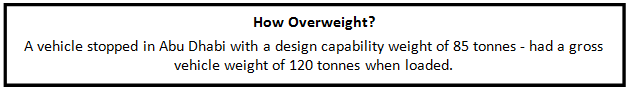
The acquisition of vehicle loading information facilitates enforcement of loading regulations and optimisation of maintenance operations.
Weight checks by public authorities traditionally involve weighing heavy vehicles on static scales, low-speed weigh-in-motion scales, at weighing stations or under portable pads placed underneath the vehicle’s tyres. They are expensive to operate because of the staff resource required. Consequently they tend to be operated for a few hours at any one time – and so only ever weigh a small proportion of potentially over-laden traffic – as well as being easy to avoid.
Improvements in technology have fostered the widespread adoption of Weigh-in-Motion (WIM) sensors across road networks - especially in Europe. Germany, Italy, Spain, Portugal, Switzerland and the United Kingdom have invested in many installations – but France outstrips them all in numbers of WIMs installed. WIM systems are generally divided into three varieties:
The future for WIM will involve improving the precision of sensors so they can be used remotely for enforcement of weight regulations in combination with some method of vehicle owner or operator identification - such as ANPR. In the UK ANPR combined with low-speed WIM or weighbridge is used to detect overweight vehicles so they can be checked by officials. (See Case Study ‘VOSA WiMs (United Kingdom))
There is the possibility of weighing some vehicles without the need for road sensor infrastructure. These are usually installed by operators who may wish to determine that their vehicles are not overloaded or may want to know how much they are carrying (for example, a tipper truck carrying gravel).
Systems can usually be broken down into two varieties - those that weigh the load and those that weigh the entire vehicle. Systems which weigh the load use load cells attached to body mounts. Systems which weigh vehicles, measure stress levels on key parts of the chassis to evaluate full vehicle weight. These systems help operators avoid unknowingly allowing overweight vehicles to be driven, whilst also ensuring that they can maximise legal payloads.
The most important aspect, when dealing with weigh stations, is to ensure that they are regularly and correctly calibrated. Mobile stations offer flexibility and prevents hauliers or operators from routing around weigh stations. It is important to keep a record of offenders, and, wherever possible, link this to other systems such as those which check credentials.
A well-managed system requires that all vehicles, drivers and operators have the correct licences, training and certificates. This is becoming significantly easier because of the combination of e-documents which can be accessed remotely using cloud based computing. Roadside enforcement officials can access all the very latest documents relating to a vehicle and deal with any infringement of regulations immediately. This capability mean that relevant information can be accessed at spot checks – for example information on roadworthiness tests (the MOT in UK, ITV in Spain, APK in the Netherlands or TÜV in Germany).
The easy availability of ITS technologies such as those described reinforces the importance of operators and drivers “playing by the rules”. Those who cut corners by illegally cutting costs distort competition and undermine legitimate operations to the detriment of the entire freight logistics market.
Building on the work from eManifest and other sources (such as safety information exchange, border clearance and weight screening) it has become possible for law enforcement officials within some countries to have access to large amounts of data at the roadside. This facilitates targeted enforcement. Vehicles from operators with poor records of compliance can be targeted, whilst those from firms with better records can be to continue without delay to their destination. In the UK, an Operator Compliance Risk Score (OCRS) system is used whereby operators ranked as low risk (“green”) are less likely to have their vehicles stopped than vehicles from operators ranked “red”. There is also an “amber” score in the middle. This score is created through a combination of roadworthiness checks and traffic enforcement compliance (drivers’ hours, weighing checks and the outcome of roadside inspections). Any discrepancies with the details recorded and accessible from the cloud - for operators, drivers or vehicles - can be checked and acted upon.
The names of credential compliance systems vary from country to country (for example, TAN21 in the United Kingdom, CVISN in the United States) but operate on a similar basis. The authorities for operators, vehicle licensing and enforcement can all upload the relevant information about the vehicle and driver where it is available in a central system that can access these databases. The system itself is accessed by roadside enforcement officials.
Intermodal freight involves the movement of loads using a combination of transport modes – shipping, inland waterways, rail, road and air. This ideally involves the use of standardised shipping containers - of which there are approximately 17 million worldwide. The negative environmental impacts is increasingly a problem of road freight particularly in long-distance and international operations. The increased volumes of freight crossing the oceans has led to more widespread use containers. This combination of factors has evolved into a new model of freight distribution – where the aim is to limit use of road transport to the last, short link, with the long-distance shipment being carried by more environmentally friendly modes. The advantage of intermodal freight is that aeroplanes, ships, railways and canals can take the lion’s share of long-distance freight flows, whilst keeping the flexibility of road transport for local and regional distribution.
Road Network Operators can benefit from modal shift if this leads to a reduction in heavy freight movements and overloaded vehicles. This is because of reductions in slower moving vehicles contributing to congestion and reduced damage to road infrastructure. Complete removal of long distance road freight is not plausible – nevertheless the European Union in its White Paper on Transport (2011) has set a target of 50% of all road freight to be shifted to more sustainable modes.
ITS plays an important part in helping enabling this to happen. ITS is at the heart of developments in intermodal freight - whether through improved efficiency and throughput of cargo terminals, better tracking of different loads internationally throughout the intermodal transport chain or simply by improving the speed and ease of border crossings.
Asset tracking, end-to-end asset tracking and eManifests enable loads to be processed far more swiftly than previously. Information about the order in which containers are entering the terminal can be transmitted in advance, ensuring that a handling plan can be set up in advance. This improves efficiency - containers or loads can be quickly moved from inbound arrival to outbound departure points without long layovers whilst their details are checked and the load’s path through the terminal is planned.
These movements can be very quick, with a 100 container train being stripped and reloaded within 90 minutes:
Such reliable, quick turnaround times make railfreight increasingly attractive to operators, as the processing time is minimised and vehicles can be used more productively.

Hams Hall Distribution Park, UK
Increasingly, as countries across the globe seek to minimise their environmental impact, road freight is being replaced, where possible, by more sustainable modes. (See Intermodal Freight) Containerisation means that it is now very easy to transport the load by a combination of inland waterway, sea, road and rail. Through the use of RFID tags it is possible to track individual containers or the contents within them across all modes - from the factory to final delivery point. Efficiencies obtained from such a detailed understanding of stock movements have significant impacts on supply chain systems. A better knowledge of estimated departure and arrival improves efficiency of distribution and a reduction in the amount of stock at any one time. (See Just-in-Time)This asset-tracking can make a significant difference as the example.
Other innovative solutions, such as GPS enabled solar powered tracking devices, allow active transmission of location data to provide constant load tracking instead of relying on the product passing through fixed monitoring points at known gateways. As GPS becomes increasingly popular within road freight, rail freight companies are also starting to use satellite technology.
Sharing of electronic data is the bedrock on which all ITS solutions are based. To be successful it is important that standards (See ITS Standards) are available to enable interoperability - so that all safety and load information can be seamlessly transferred between countries, operators and regulators.
The eManifest, as an electronic depository of the contents of all trucks, simplifies border clearance, credential checking and terminal processing. It also supports intermodal transport operations providing the transport operators and shippers in the intermodal chain with access to the same documentation. This facilitates an unbroken journey between transport providers and between transport modes.
eManifests provide operators and the emergency services with access to much needed data - without having to rely on paper copies which may be damaged, lost, or only held within the vehicle itself. Emergency response is helped by knowing the contents of any freight vehicle involved in an incident. The eManifest also helps operators maintain good access to data about their current loads and destinations.