


Journey Time Monitoring
Keeping track of vehicle journey times involves the measurement, interpretation and communication of vehicle detector data from multiple sources. Monitoring of journey times provides information necessary to determine the operational status of the network and level of service available to road users. (See Measuring Performance)
It is important to build user confidence on the reliability of journey time predictions. In some instances data may not be delivered in a timely manner or may be incomplete or inaccurate. The accurate and timely delivery of journey time information contributes to:
- informed travellers, able to make better decisions on choice of mode and route during pre-trip planning or en-route travel
- informed public and private road operators, able to make better short and long-term plans for the management of their road networks
- enabling incident detection and demand management measures
The purpose of journey time monitoring varies and depends on the objectives of the end user. For example:
- if a public sector agency has subcontracted the responsibility for road operations and maintenance to a private contractor, then journey time measurement can indicate if the organisation is meeting its performance targets – and may impact on payments made
- road users may choose from a variety of routes (or modes) with different travel time end-points or objectives – such as:
- expected journey time to reach the end of a road section, an urban area or the entrance to a tunnel
- expected arrival time of the next bus
Whilst journey time information is easy to understand, it is complex to calculate. Typically, a sensor network may include one or more types of detectors – each having different levels of accuracy, reporting rate, availability and reliability. Different methodologies and traffic models exist to aggregate real-time data, predict traffic conditions and calculate travel time information for the benefit of TCC managers and road users.
Trajectory measurement (tracking vehicle paths through a network from one point to another) and probe vehicles may be used to determine the travel time on road sections using various vehicle identification technologies. Examples are, toll tags and cameras that read a Vehicle Registration Mark (VRM).
The growth in the use of satellite navigation systems that can (with the consent of a user) provide speed and location information to third party service providers – adds to the level of detail of traffic information that may be provided to TCC staff and road users.
Complex and dense road networks provide greater challenges to measure and interpret data since each road segment is more closely interrelated with others compared to interurban roads. Combining data from different sources may be used to determine the operating status of a road network. The data collected must be reliable and the calculation algorithms must be accurate since end users will expect consistency between their experience on the journey and the information provided to them during the journey.
Technologies, Data and Resources
Many technologies provide the basis for systems that:
- determine the travel time of vehicles on specific road links
- calculate the journey time for the link
- predict journey times for vehicles entering the link
- provide the basis for average speed enforcement
A single static measurement point cannot provide travel time information and a detector network that is intended for simple detection and vehicle counting may not provide a suitable starting point for reliable journey time measurement. Additional information on vehicle speed and progress on the road network is needed:
- combining spot speed measurement with probe vehicle data for journey time measurements
- combining real-time measurements with historical data for interpretation and filling the gaps in data
The most reliable journey time calculations use historical information and spot speed measurements to improve estimates, particularly in dense urban environments with complex road networks, such as Hong Kong.(See Vehicle Detection, Probe Vehicle Measurement and Network Monitoring Application Areas)
Spot Speeds and Probe Vehicles
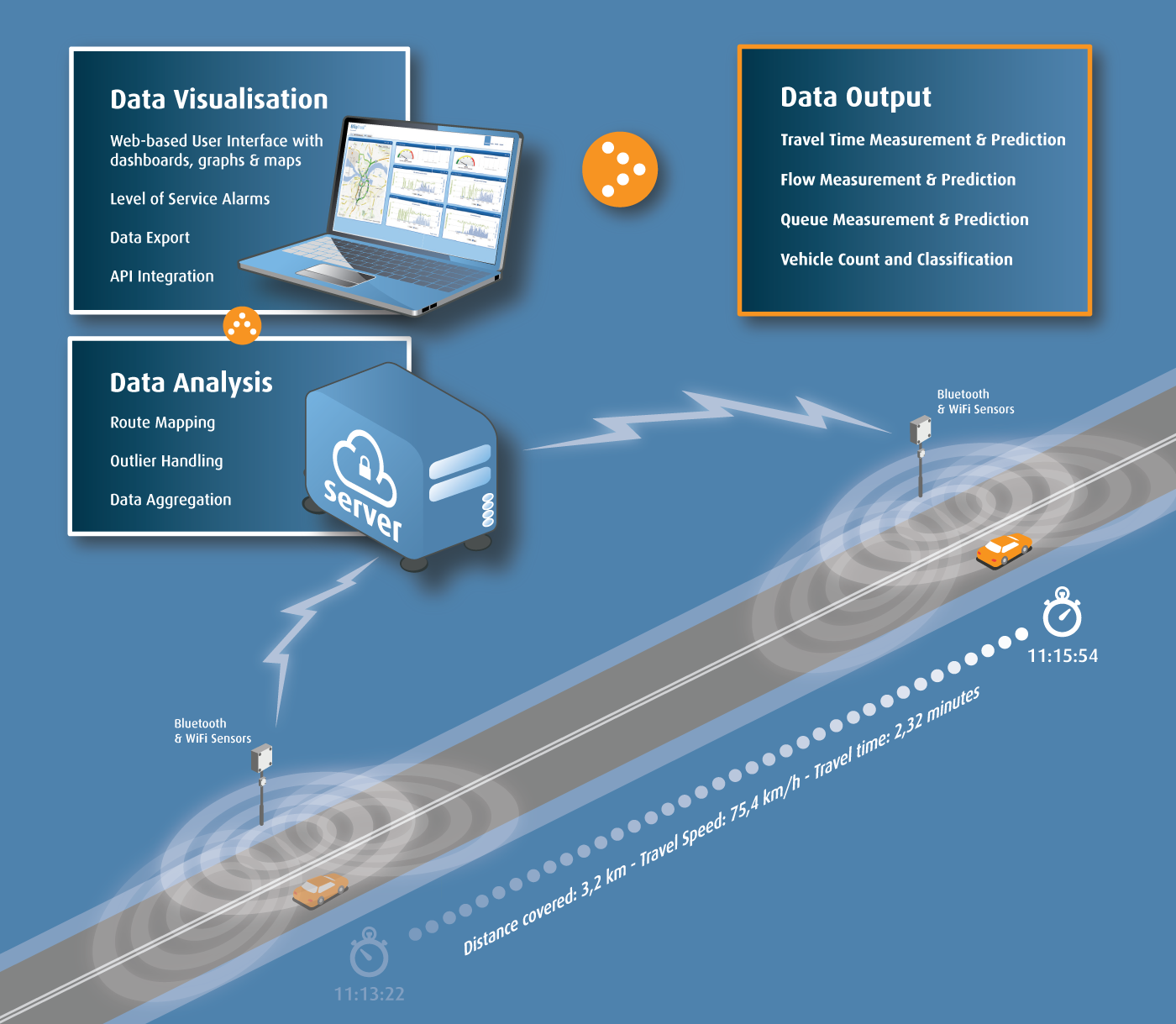
A combination of probe vehicle data and spot speed measurement can be used for journey time measurements. For example, capturing the identification signal from a small proportion of devices equipped with Bluetooth (in mobile phones and in-car audio systems) at different locations on the same link – enables the average speed on the link to be calculated as illustrated in the diagram below. This is done by dividing the distance between the detectors by the travel time measured over this distance. Alternatively Automatic Number Plate Recognition (ANPR) or Radio Frequency Identification (RFID) readers can be used to provide similar data.
Real-time and Historical Data
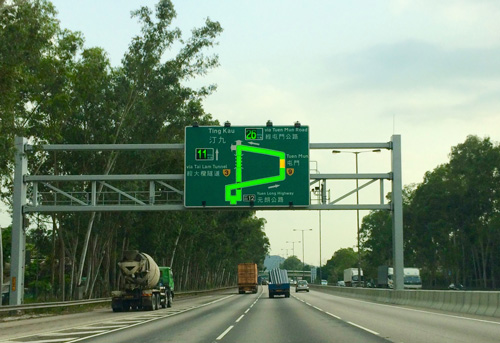
Combining real-time measurements of link speed with real-time measurement of spot speed and historical data from related links - enables journey times between measured points to be calculated and presented as reliable predictions to road users in real-time – and can be displayed using colour graphics, as in the photograph below.
Average Speed Enforcement
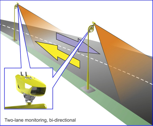
Average speed enforcement requires an accurate detection of the presence of identified vehicles at two locations separated by a known, precisely determined separation. This is illustrated below. Increasing the number of measuring points will increase the probability that the same vehicle (or in-vehicle device) will be seen elsewhere on the road network. If the measured speed is higher than a predetermined level (with an allowance for potential errors) the images captured are evidential-quality images and can be used to prosecute vehicle owners.
Advice to Practitioners
When deciding whether to invest in the infrastructure for journey time monitoring, issues to consider include:
- the time and cost of installing detection equipment
- the cost of providing power, maintenance and communications
- the variety of channels from which information may be made available – such as roadside VMS, graphical display panels, the internet or mobile phones
Journey times may help identify incidents by comparing calculated values with historical information to allow prompt action to be taken. When designing the algorithms the effect of roadworks, unplanned incidents or planned events needs to be taken into account. This often requires local expertise on likely traffic behaviour.
Issues for developing economies
Traditionally static roadside detectors have been used for journey time measurement. As the quality and capability of mobile phones develops, there is an opportunity to use their location-based data capabilities to measure link speed without the cost of deploying and maintaining static detectors, drawing on:
- location based services (for commercial and safety reasons)
- satellite navigation systems (such as GPS, Galileo, Glonass or BeiDou2)
Where market penetration by mobile phones is low, or where there are low levels of traffic – static roadside journey time detectors will be needed. Manual monitoring of road links can provide real-time information on road network performance – but this method cannot reliably determine journey times without being supplemented by other measurements or by adopting a small proportion of probe vehicles (such as long-distance coaches).
US Federal Highways Administration (2011) Travel Time Data Collection Handbook pp5-4 to 5-5, http://www.fhwa.dot.gov/ohim/tvtw/natmec/00020.pdf
EasyWay Consortium (2012) Traffic Condition and Travel Time Information ITS Deployment Guideline, TIS-DG03-05, available for download at: http://dg.easyway-its.eu/DGs2012
Lam, W. (2013) Intelligent Transport Systems (ITS) In Hong Kong: Recent Development and Future Applications, The Hong Kong Polytechnic University