


Context for Network Monitoring
Road network monitoring is a strategic function that enables effective road network operations and incident management. The purpose of network monitoring is to secure accurate, reliable and up-to-date information about road and traffic conditions across the network. A number of activities are required to achieve this:
- developing and maintaining the network description and an associated location referencing system (See Basic Info-structure)
- obtaining information about roadworks on the network (See TCC Functions)
- obtaining information about planned events affecting traffic on the network (See Planned Events)
- obtaining information about unplanned events such as traffic accidents (See Traffic Incidents and Emergency Response)
- monitoring of traffic conditions across the network (See Monitoring Activities)
- monitoring of adverse weather conditions which may have an impact (See Weather Management)
Traditionally, roads and highways were owned and managed by public bodies as an asset. In the past these bodies were responsible for deploying traffic detectors, filtering and combining their outputs, making them available for traffic management purposes and for displaying messages on Variable Message Signs (VMS). Many road authorities still do this, but in recent years several trends have contributed toward new organisational structures for network monitoring, including:
- the ‘big shift’ of traffic authorities from being an asset owner to a service provider (See Road User Services)
- the increasing use of private finance to provide new infrastructure (for example in Chile and Australia) (See Finance & Contracts)
- the increased pace of development in new vehicle detection technologies (See Vehicle Detection Technologies)
- the rapid growth of mobile phone usage, messaging services and the mobile internet (See New forms of Mobility and Social Media & Data)
Private sector service providers have a growing role. Innovations in mobile social networks and mobile phone-based navigation services mean that the users of traffic information may also act as a source of traffic data, otherwise known as ‘crowd-sourced’ data. (See Data and Communications) In future, this may complement conventional point-based vehicle detectors in regions that cross-administrative boundaries, on roads where detectors do not exist, or even on roads where detectors do exist. These new data services (See Future Trends) can assist and complement public highway agencies.
Functional Architecture
The typical functional architecture of an ITS service that monitors traffic conditions and travel times is shown in ‘The Information Chain’ in the figure below. (See Data and Information)
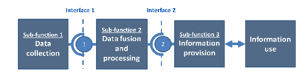
The ITS architecture for the information chain comprises three parts:
Sub-function 1 – the devices and applications for the collection of traffic data (in addition to weather and journey-time monitoring) from:
- single and multiple measurement locations
- on-road data capture systems
- vehicles (See Vehicle & Roadways)
Sub-function 2 – the processing that combines real time data with any traffic prediction and journey time information that may be derived from the sensor data collected. (See Data Aggregation and Analysis)
Sub-function 3 – the selection, organisation and presentation of information (derived from sub-functions 1 and 2) to the Traffic Control Centre (TCC) operator.
The main application area for network monitoring are:
- Traffic and Network Status Monitoring (See Traffic and Network Status Monitoring)
- Weather Monitoring (See Weather Monitoring)
- Journey Time Monitoring (See Journey Time Monitoring)
EasyWay Consortium (2012) Traffic Condition and Travel Time Information – ITS Deployment Guideline TIS-DG03-05 available for download at: http://dg.easyway-its.eu/DGs2012
EasyWay Consortium (2012) Traffic Management Services - Incident Warning and Management - ITS Deployment Guideline TIS-DG05-08 available for download at: http://dg.easyway-its.eu/DGs2012