


Weather Monitoring
Weather monitoring is focused on the impact of weather on driving conditions and the operational measures needed to minimise travel disruption. The accuracy and timely delivery of weather information and weather warnings contributes to informed road users, an increase in road safety (by reducing the probability of an incident), and reduced operational costs of commercial vehicles, snow and ice clearing.
Weather monitoring is the measurement, communication and interpretation of weather information from multiple sources. The TCC’s weather monitoring function is focused on monitoring the condition of road surfaces, driving visibility and the use of infrastructure-specific information relating to the road network - such as bridges (which can be closed due to high wind conditions) and tunnels (that may be liable to flooding).
Current and predicted weather conditions on a road are critical to users planning a journey or already travelling on the road. The intention of a weather monitoring service is to encourage different user groups to adapt their travel plans (route, mode, timing) or change driver behaviour (speed) - to avoid the negative impacts associated with weather conditions. To make informed choices, travellers need to be aware of the likely weather along their route.
The benefits of timely and accurate delivery of weather information and weather warnings include:
- more informed road users – better able to make better decisions on choice of mode, timing of journey and driving behaviour
- an increase in road safety (by reducing the probability of an incident)
- reduced costs of commercial vehicle operations (by enabling adjustments to freight plans)
- reduced costs of operations involving snow ploughs and de-icing vehicles (by improving resource planning)
Weather Monitoring and Warning Systems
The Finnish Transport Agency operates a national route monitoring service that reports on driving conditions from mid-September to mid-May. Highways England provides an on-line search tool for the latest traffic reports presented on a road-by-road basis, that allows user to search for weather-related warnings – See http://www.highways.gov.uk/traffic-information/
Technologies, Data and Resources
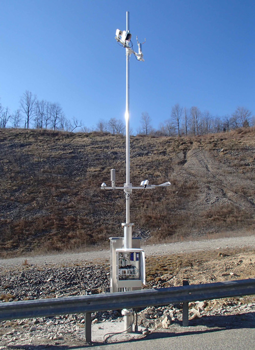
Regional and route-based weather stations are the most common static measurement systems – although the weather monitoring function must also have the capacity to accept ad-hoc reports from other organisations. This will include the police, other transport service providers, a national meteorological centre and members of the public. Roadside measurement stations are most commonly used for localised weather monitoring – such as the one shown below.
Traditionally road users have had to actively request information before undertaking a journey. The recent introduction of improved digital radio broadcasting methods now mean that road users can subscribe to services providing regional or route-based messages and other weather alerts during their journey. Examples are Radio Data System-Traffic Message Channel (RDS-TMC), radio break-in services, instant messaging technologies such as the Short Messaging Service, Twitter and Sina Weibo – and roadside Variable Message Signs (VMS). This trend from users requesting information (‘pull’) to users being informed (‘push’) increases road users’ knowledge of weather conditions along their journey. (See En-route Information) Services providing traffic-related messaging announcements are widely used in Australia, Brazil, Czech Republic, Italy, South Africa, Sweden and other countries.
Advances in computer-based ‘expert systems’ are improving the accuracy of predictions by taking into account historic information and trends. The technology continues to develop quickly - such as the piloting of specialised GPS-based measurement stations in the USA to detect atmospheric variations (such as rainfall) based on the measurement of the travel time of signals from satellites. Complementary technologies include wireless communications (from roadside stations for example) and sophisticated back office computational resources.
Advice to Practitioners
The data aggregation processes should provide dynamic weather information for specific roads, road segments, routes or administrative areas - updated at defined intervals such as every 5, 15 or 60 minutes depending on how quickly the weather conditions are changing. The information collected needs to be relevant to the target audience. It can be customised to assist those involved in road maintenance and infrastructure management or to provide travel information to road users.
Weather information that is broadcast to road users may include information on the condition of the road surface, particularly at exposed sections such as bridges that may be more prone to surface ice, high winds or rain. The most common dynamic information that is measured is:
- temperature, wind direction and wind speed
- rainfall
- specific information on infrastructure (bridges, roads) prone to flooding
- regional and national weather forecasts and weather warnings relating to fog, ice and heavy rain
Integrated monitoring stations combine traffic monitoring, emissions monitoring and weather conditions. These monitoring stations can be pre-set to report only if conditions exceed specified levels such as a reduction in temperature, road friction and grip - that may indicate the possibility of localised icing or perhaps a reduction in visibility.
INSTITUTIONAL ISSUES
Typically, traffic management staff are not responsible for interpreting the wide variety of data sources. Instead, external experts may be contracted to provide customised reports for the purposes of traffic management. These experts may be part of the national meteorological service or weather bureau.
Weather information may be gathered from data sources owned by others in the public or private sectors. Partnership agreements may be required to allow sharing of data between organisations and its interpretation – for example, in relation to:
- fixed road weather monitoring stations (possibly complemented by mobile units)
- CCTV cameras with suitable algorithms to extract weather information from image streams - owned by urban, regional or national traffic management authorities
- private sector internet-based crowd sourcing data providers (to help confirm or refine measurements made by more conventional detection methods)
- other sources such as educational institutions and other public authorities
LEGACY, OBSOLESENCE AND UPGRADE ISSUES
The long-term development of a weather monitoring service needs to take into account any potential increase in the size of the geographical coverage, the use of standards and a common approach to reporting. To enable a common understanding by all travellers, a uniform presentation of weather-related signing and messages is recommended, to ensure a ‘common look and feel’.
Interoperability requirements may also apply – to ensure that sensor networks can be expanded without significant modification and to make it easier for other parties to provide customised weather reports to traffic authorities. Data standards may be used to enable the transfer of weather data between back offices - although it is likely that these standards will be needed anyway to improve communication between TCCs or with other government agencies. Examples of these ‘centre-to-centre’ standards include DATEX II (Data Exchange) which is the most common in Europe and NTCIP which is the most common in the USA. The Transport Department of China maintains a comparable library of standards.
Issues for developing economies
The high cost of establishing comprehensive weather monitoring and early warning systems for extreme weather can be a barrier to many countries wishing to protect their national road network. This may have a critical impact on inter-regional trade and urban infrastructure such as roads and drainage systems.
Regional Associations of the World Meteorological Organisation (WMO) provide a valuable resource for sharing best practice of weather monitoring and multi-hazard warning systems between regions. It helps provide access to sources of regional weather reports and promotes methods of risk management and climate change adaptation.
Weather monitoring stations should be compact, easy to install, have low ownership costs (purchase, maintenance and upgrade) and operate on a long-term basis, without interruption, in regions that are most likely to suffer for weather-related conditions. Investments in early warning systems can also reduce the potential cost of a disaster response and ensure faster deployment of emergency services.
Subcontracting parts of the monitoring system to private sector contractors - to provide and maintain a network of weather stations and lightning discharge measurement systems - may provide a pragmatic solution to developing weather measurement networks without the public sector having to be responsible for their ownership.
Finnish Transport Agency, Road Condition home page, http://www2.liikennevirasto.fi/alk/english/keliennuste/
Highways England (UK): http://www.trafficengland.com/motorwayflow.aspx
World Meteorological Association (WMO): http://www.wmo.int
DATEX is a standard developed for information exchange between traffic management centres, traffic information centres and service providers. The DATEX II Guideline DTX-DG01 is available for download at: http://dg.easyway-its.eu/DGs2012
EasyWay Consortium (2012) Weather Information ITS Deployment Guideline, TIS-DG06 available for download at: http://dg.easyway-its.eu/DGs2012