
Road network monitoring is a strategic function that enables effective road network operations and incident management. The purpose of network monitoring is to secure accurate, reliable and up-to-date information about road and traffic conditions across the network. A number of activities are required to achieve this:
Traditionally, roads and highways were owned and managed by public bodies as an asset. In the past these bodies were responsible for deploying traffic detectors, filtering and combining their outputs, making them available for traffic management purposes and for displaying messages on Variable Message Signs (VMS). Many road authorities still do this, but in recent years several trends have contributed toward new organisational structures for network monitoring, including:
Private sector service providers have a growing role. Innovations in mobile social networks and mobile phone-based navigation services mean that the users of traffic information may also act as a source of traffic data, otherwise known as ‘crowd-sourced’ data. (See Data and Communications) In future, this may complement conventional point-based vehicle detectors in regions that cross-administrative boundaries, on roads where detectors do not exist, or even on roads where detectors do exist. These new data services (See Future Trends) can assist and complement public highway agencies.
The typical functional architecture of an ITS service that monitors traffic conditions and travel times is shown in ‘The Information Chain’ in the figure below. (See Data and Information)
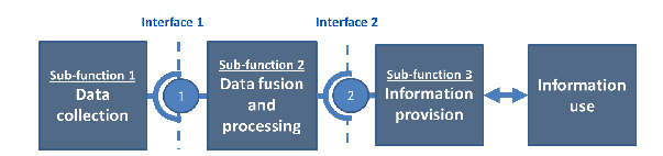
The Information Chain. Reproduced by permission of the Easyway Consortium (http://www.easyway-its.eu.) a trans-European project co-financed by the European Commission.
The ITS architecture for the information chain comprises three parts:
Sub-function 1 – the devices and applications for the collection of traffic data (in addition to weather and journey-time monitoring) from:
Sub-function 2 – the processing that combines real time data with any traffic prediction and journey time information that may be derived from the sensor data collected. (See Data Aggregation and Analysis)
Sub-function 3 – the selection, organisation and presentation of information (derived from sub-functions 1 and 2) to the Traffic Control Centre (TCC) operator.
The main application area for network monitoring are:
Predictive and real-time information about traffic conditions and travel times contributes strongly to the improvement of traffic efficiency. It enables road operators to understand how well the road network is operating, and enables the timely detection of incidents. For example, a TCC may wish to measure the performance of its road network to provide tangible evidence that the methods to reduce congestion and improve the consistency of journey times are having a positive effect. Visualisation of the state of the road network at the TCC, interpreted from a network of static and mobile detectors, is critical. (See Traffic & Network Status Monitoring)
Traffic and network status monitoring activity involves:
Effective traffic and road network status monitoring depends on a combination of static detectors, Closed Circuit Television Cameras (CCTV) and ad-hoc reports of unplanned incidents. Ad-hoc sources include the police, road authorities, vehicle breakdown organisations and public transport operators. (See Other Monitoring Sources) The TCC will use the data to monitor traffic, manage incidents and monitor weather and road surface conditions. (See Operational Activities and ITS & Road Safety)
CCTV cameras have traditionally been a source of real-time traffic information and the means for Traffic Control Centre (TCC) operators to validate reported incidents. The operator also needs to be presented with a general view of the road network which draws attention to information relevant to the operator’s task. This could include traffic flow, occupancy, queue length, equipment status and messages that are presented to road users by Highway Advisory Radio (HAR) and Variable Message Signs (VMS). The public sector or third parties are generally responsible for data collection and its aggregation – whilst users of the information will include the TCC operators, other stakeholders and the general public - as shown in the figure below.
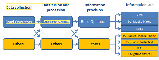
Organisational Model and the relationship with other parties. Reproduced by permission of the Easyway Consortium (http://www.easyway-its.eu) a trans-European project co-financed by the European Commission.
The same combination of technologies (hardware, software and computer graphics) will also provide the means to configure and update traffic plans and manage voice communications with the TCC (such as telephone call set-up and recording), reporting, organisational performance management and operator training. (See Operational Activities)
Many technologies provide the basis for systems to monitor traffic levels and determine the real-time performance of a road network. (See Vehicle Detection and Probe Vehicle Measurement) The systems aggregate the data and make them available to the TCC operators and for Automatic Incident Detection (AID) systems. (See Automatic Incident Detection (AID)) Typically the components required for a highly reliable, fault-tolerant and flexible system architecture at the TCC - for the purposes of information collection, storage and presentation - may be split into four categories:
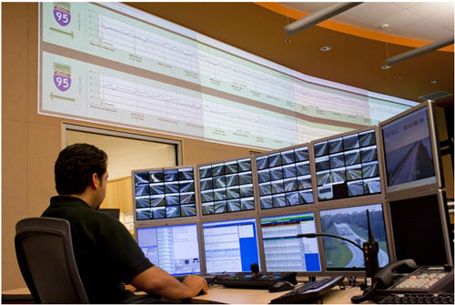
System Status Wall Display and operator workstation, Florida District 4
Wall Display, Costanera Norte, Santiago de Chile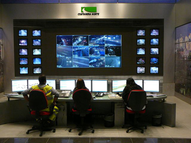
The TCC will also be equipped with telephone (conventional circuit-switched or Voice over Internet Protocol) and a Private Mobile Radio (PMR) system.
The key to successful traffic operations is inter-agency cooperation and coordination – for example between the TCC and other stakeholders such as the emergency services, major vehicle fleet operators, ports, airports and rail stations. (See Interagency Working).The extent of inter-agency cooperation has a major impact on the TCC’s operations and the support systems required. Integration can be facilitated by co-locating stakeholders in the TCC – as happened during the London Olympic Games.
When a new TCC is being planned or an existing TCC is being upgraded – it is important that the TCC system architecture (including the collection of traffic data) is aligned with the requirements of core applications. This is– usually split between highway management and arterial route management. These are often the responsibilities of different agencies but in future more integrated solutions may become available. (See Regional networks)
The system architecture should be designed to enable more efficient TCC operations at lower cost. For example, as the complexity of the network monitoring infrastructure expands, the architecture should provide for greater use of automated system health monitoring. This ensures that the TCC and field equipment are performing their expected functions properly. (See What is ITS Architecture?)
The use of proprietary interfaces for vehicle detection and traffic monitoring systems can increase the cost of expansion and increase the dependency on a small number of technology vendors and system integrators. Requiring standards-compliant interfaces can help retain supplier independence for the road operator – providing the requirement generates a market response. (See ITS Standards)
Any changes to a system needed to accommodate technology innovations is likely to impact on maintenance and operator workflow - requiring training, a revision to documented procedures and potentially – opportunities for innovation. For example, the use of a Knowledge-based Expert System (KBEST) to provide recommendations to TCC operators on traffic plans, is an innovation that can improve the efficiency of staff having to monitor several routes simultaneously. (See Future Trends)
CCTV cameras can help monitor traffic conditions, detect incidents, validate them, monitor the emergency services and help manage incident clearance. In some applications, 80% of incidents are detected with CCTV cameras – although their performance is compromised at night on routes without artificial lighting. CCTV cameras can be subject to vandalism and their communication cables subject to theft, even if optical fibre cables are used. TCC operators may wish to transfer some of the upgrade and operating risks to third parties (see box on Design, Build, Operate and Maintain - below). The involvement of third parties in data collection and data analysis (on an availability payments basis) can replace the need for expensive investment in additional network monitoring infrastructure.
Design, Build, Operate and Maintain
The South African National Roads Agency (SANRAL) awarded a Design Build Operate and Maintain (DBOM) contract to a single contractor who was responsible for the refurbishment and upgrading of regional TMCs. This included the addition of new traffic monitoring infrastructure, its maintenance, operations and coordination with communication service providers and emergency service providers (Case Study - ITS Design & Operating Services, South African National Roads Agency (SANRAL) (South Africa)).
Pressure on TCCs is higher than ever before in the face of:
Traditionally, vehicle detection and traffic monitoring systems lacked the capability to perform data error correction, data analysis, self-diagnostics and reporting. As the capability of these systems has improved, more data needs to be exchanged with the TCC – and health monitoring may be centralised at the TCC.
In practice, each function of a TCC relating to network monitoring can be upgraded separately. This can be facilitated by dividing the TCC into functional modules and developing upgrade requirements for each:
Weather monitoring is focused on the impact of weather on driving conditions and the operational measures needed to minimise travel disruption. The accuracy and timely delivery of weather information and weather warnings contributes to informed road users, an increase in road safety (by reducing the probability of an incident), and reduced operational costs of commercial vehicles, snow and ice clearing.
Weather monitoring is the measurement, communication and interpretation of weather information from multiple sources. The TCC’s weather monitoring function is focused on monitoring the condition of road surfaces, driving visibility and the use of infrastructure-specific information relating to the road network - such as bridges (which can be closed due to high wind conditions) and tunnels (that may be liable to flooding).
Current and predicted weather conditions on a road are critical to users planning a journey or already travelling on the road. The intention of a weather monitoring service is to encourage different user groups to adapt their travel plans (route, mode, timing) or change driver behaviour (speed) - to avoid the negative impacts associated with weather conditions. To make informed choices, travellers need to be aware of the likely weather along their route.
The benefits of timely and accurate delivery of weather information and weather warnings include:
Weather Monitoring and Warning Systems
The Finnish Transport Agency operates a national route monitoring service that reports on driving conditions from mid-September to mid-May. Highways England provides an on-line search tool for the latest traffic reports presented on a road-by-road basis, that allows user to search for weather-related warnings – See http://www.highways.gov.uk/traffic-information/
Regional and route-based weather stations are the most common static measurement systems – although the weather monitoring function must also have the capacity to accept ad-hoc reports from other organisations. This will include the police, other transport service providers, a national meteorological centre and members of the public. Roadside measurement stations are most commonly used for localised weather monitoring – such as the one shown below.
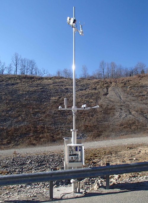
Route-based weather data measurement, Virginia (USA)
Traditionally road users have had to actively request information before undertaking a journey. The recent introduction of improved digital radio broadcasting methods now mean that road users can subscribe to services providing regional or route-based messages and other weather alerts during their journey. Examples are Radio Data System-Traffic Message Channel (RDS-TMC), radio break-in services, instant messaging technologies such as the Short Messaging Service, Twitter and Sina Weibo – and roadside Variable Message Signs (VMS). This trend from users requesting information (‘pull’) to users being informed (‘push’) increases road users’ knowledge of weather conditions along their journey. (See En-route Information) Services providing traffic-related messaging announcements are widely used in Australia, Brazil, Czech Republic, Italy, South Africa, Sweden and other countries.
Advances in computer-based ‘expert systems’ are improving the accuracy of predictions by taking into account historic information and trends. The technology continues to develop quickly - such as the piloting of specialised GPS-based measurement stations in the USA to detect atmospheric variations (such as rainfall) based on the measurement of the travel time of signals from satellites. Complementary technologies include wireless communications (from roadside stations for example) and sophisticated back office computational resources.
The data aggregation processes should provide dynamic weather information for specific roads, road segments, routes or administrative areas - updated at defined intervals such as every 5, 15 or 60 minutes depending on how quickly the weather conditions are changing. The information collected needs to be relevant to the target audience. It can be customised to assist those involved in road maintenance and infrastructure management or to provide travel information to road users.
Weather information that is broadcast to road users may include information on the condition of the road surface, particularly at exposed sections such as bridges that may be more prone to surface ice, high winds or rain. The most common dynamic information that is measured is:
Integrated monitoring stations combine traffic monitoring, emissions monitoring and weather conditions. These monitoring stations can be pre-set to report only if conditions exceed specified levels such as a reduction in temperature, road friction and grip - that may indicate the possibility of localised icing or perhaps a reduction in visibility.
Typically, traffic management staff are not responsible for interpreting the wide variety of data sources. Instead, external experts may be contracted to provide customised reports for the purposes of traffic management. These experts may be part of the national meteorological service or weather bureau.
Weather information may be gathered from data sources owned by others in the public or private sectors. Partnership agreements may be required to allow sharing of data between organisations and its interpretation – for example, in relation to:
The long-term development of a weather monitoring service needs to take into account any potential increase in the size of the geographical coverage, the use of standards and a common approach to reporting. To enable a common understanding by all travellers, a uniform presentation of weather-related signing and messages is recommended, to ensure a ‘common look and feel’.
Interoperability requirements may also apply – to ensure that sensor networks can be expanded without significant modification and to make it easier for other parties to provide customised weather reports to traffic authorities. Data standards may be used to enable the transfer of weather data between back offices - although it is likely that these standards will be needed anyway to improve communication between TCCs or with other government agencies. Examples of these ‘centre-to-centre’ standards include DATEX II (Data Exchange) which is the most common in Europe and NTCIP which is the most common in the USA. The Transport Department of China maintains a comparable library of standards.
The high cost of establishing comprehensive weather monitoring and early warning systems for extreme weather can be a barrier to many countries wishing to protect their national road network. This may have a critical impact on inter-regional trade and urban infrastructure such as roads and drainage systems.
Regional Associations of the World Meteorological Organisation (WMO) provide a valuable resource for sharing best practice of weather monitoring and multi-hazard warning systems between regions. It helps provide access to sources of regional weather reports and promotes methods of risk management and climate change adaptation.
Weather monitoring stations should be compact, easy to install, have low ownership costs (purchase, maintenance and upgrade) and operate on a long-term basis, without interruption, in regions that are most likely to suffer for weather-related conditions. Investments in early warning systems can also reduce the potential cost of a disaster response and ensure faster deployment of emergency services.
Subcontracting parts of the monitoring system to private sector contractors - to provide and maintain a network of weather stations and lightning discharge measurement systems - may provide a pragmatic solution to developing weather measurement networks without the public sector having to be responsible for their ownership.
Keeping track of vehicle journey times involves the measurement, interpretation and communication of vehicle detector data from multiple sources. Monitoring of journey times provides information necessary to determine the operational status of the network and level of service available to road users. (See Measuring Performance)
It is important to build user confidence on the reliability of journey time predictions. In some instances data may not be delivered in a timely manner or may be incomplete or inaccurate. The accurate and timely delivery of journey time information contributes to:
The purpose of journey time monitoring varies and depends on the objectives of the end user. For example:
Whilst journey time information is easy to understand, it is complex to calculate. Typically, a sensor network may include one or more types of detectors – each having different levels of accuracy, reporting rate, availability and reliability. Different methodologies and traffic models exist to aggregate real-time data, predict traffic conditions and calculate travel time information for the benefit of TCC managers and road users.
Trajectory measurement (tracking vehicle paths through a network from one point to another) and probe vehicles may be used to determine the travel time on road sections using various vehicle identification technologies. Examples are, toll tags and cameras that read a Vehicle Registration Mark (VRM).
The growth in the use of satellite navigation systems that can (with the consent of a user) provide speed and location information to third party service providers – adds to the level of detail of traffic information that may be provided to TCC staff and road users.
Complex and dense road networks provide greater challenges to measure and interpret data since each road segment is more closely interrelated with others compared to interurban roads. Combining data from different sources may be used to determine the operating status of a road network. The data collected must be reliable and the calculation algorithms must be accurate since end users will expect consistency between their experience on the journey and the information provided to them during the journey.
Many technologies provide the basis for systems that:
A single static measurement point cannot provide travel time information and a detector network that is intended for simple detection and vehicle counting may not provide a suitable starting point for reliable journey time measurement. Additional information on vehicle speed and progress on the road network is needed:
The most reliable journey time calculations use historical information and spot speed measurements to improve estimates, particularly in dense urban environments with complex road networks, such as Hong Kong.(See Vehicle Detection, Probe Vehicle Measurement and Network Monitoring Application Areas)
A combination of probe vehicle data and spot speed measurement can be used for journey time measurements. For example, capturing the identification signal from a small proportion of devices equipped with Bluetooth (in mobile phones and in-car audio systems) at different locations on the same link – enables the average speed on the link to be calculated as illustrated in the diagram below. This is done by dividing the distance between the detectors by the travel time measured over this distance. Alternatively Automatic Number Plate Recognition (ANPR) or Radio Frequency Identification (RFID) readers can be used to provide similar data.
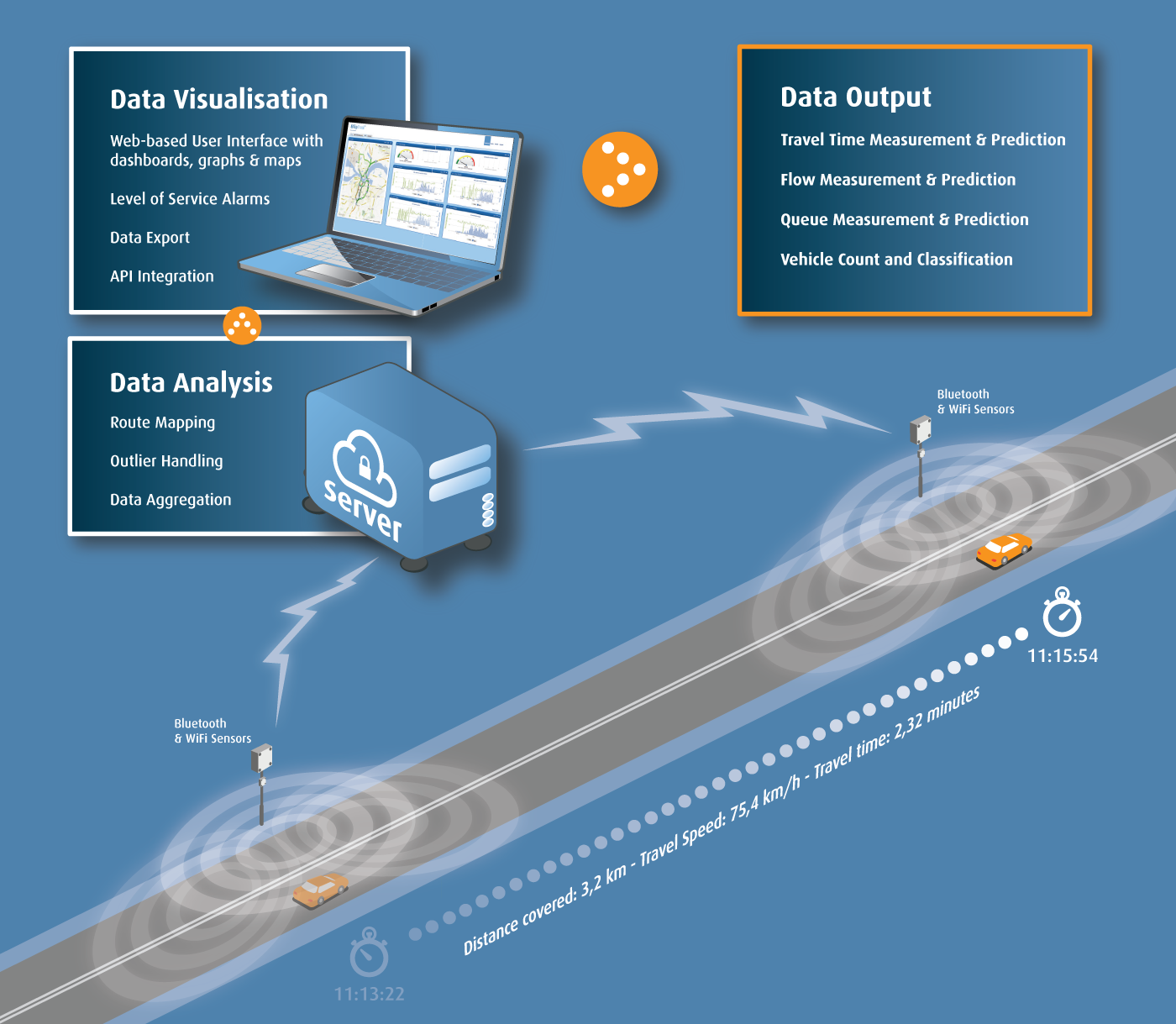
Journey time measurement on a road section
Combining real-time measurements of link speed with real-time measurement of spot speed and historical data from related links - enables journey times between measured points to be calculated and presented as reliable predictions to road users in real-time – and can be displayed using colour graphics, as in the photograph below.
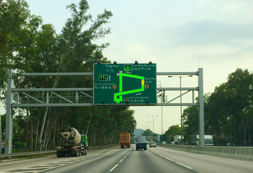
Speed Map Panel System (SMPS) on Route 3 at Yuen Long, Hong Kong
Average speed enforcement requires an accurate detection of the presence of identified vehicles at two locations separated by a known, precisely determined separation. This is illustrated below. Increasing the number of measuring points will increase the probability that the same vehicle (or in-vehicle device) will be seen elsewhere on the road network. If the measured speed is higher than a predetermined level (with an allowance for potential errors) the images captured are evidential-quality images and can be used to prosecute vehicle owners.
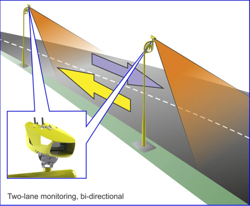
Average (point-to-point) speed cameras used on motorways
When deciding whether to invest in the infrastructure for journey time monitoring, issues to consider include:
Journey times may help identify incidents by comparing calculated values with historical information to allow prompt action to be taken. When designing the algorithms the effect of roadworks, unplanned incidents or planned events needs to be taken into account. This often requires local expertise on likely traffic behaviour.
Traditionally static roadside detectors have been used for journey time measurement. As the quality and capability of mobile phones develops, there is an opportunity to use their location-based data capabilities to measure link speed without the cost of deploying and maintaining static detectors, drawing on:
Where market penetration by mobile phones is low, or where there are low levels of traffic – static roadside journey time detectors will be needed. Manual monitoring of road links can provide real-time information on road network performance – but this method cannot reliably determine journey times without being supplemented by other measurements or by adopting a small proportion of probe vehicles (such as long-distance coaches).