Road Network Operations
& Intelligent Transport Systems
A guide for practitioners!

Road Network Operations
& Intelligent Transport Systems
A guide for practitioners!
A barrier to those wishing to use public transport services, is not knowing where they need to go to catch their transport service. “Where’s my nearest?” transport services aim to remove this by uncertainty by providing information on the nearest transport facilities. Historically these have been provided as pre-trip information (website or paper based media – such as “where to board your bus” paper maps) and as en-route information using paper, “where to board your bus” posters. Today, smartphones equipped with GPS or other location sensing technology allow this information to be presented at any location using an appropriate mobile application. In addition to public transport information, the location of parking spaces, taxis or car sharing vehicles can also be reported.
Ideally, multi-channel information should be consistent across all media - with the ‘Where’s My Nearest’ transport service applications using the same design style and mapping as other paper based and digital channels. This would mean that street wayfinding totems, public transport paper based mapping and where’s my nearest apps all have the same family 'brand'.
Emerging technology such as Wifi-sensing, Bluetooth or iBeacons (an Apple proprietary protocol using Bluetooth 3) seeks to provide more accurate location information suitable for location finding in an indoor environment. Thess could be used to provide guidance to the location of departure platforms, gates or stands in a large transport interchange, such as a railway station or airport.
Specially tailored apps or phones designed for people with disabilities can help overcome their difficulties in finding specific transport facilities.
A GPS chipset is generally now a standard feature of most smartphone handsets. This allows Apps installed on the phone to detect their location and present information based on that location. Thelocation is obtained from interpreting signals from multiple satellites. Generally the stronger, or more numerous, the satellite signals, the more accurate the location. Outside, in an open area, smartphones can provide a location accurate to a few metres. If the phone is located inside a vehicle or a building, or if there are large buildings nearby - the signal and accuracy of the location can be impeeded. The latest mobile phone operating systems including Android and iOS also use the presence of nearby wifi signals to enhance the accuracy of locations. The accuracy of a GPS signal is measured by the Dilution of Precision (DOP).
Typically, GPS alone, is not sufficient for providing wayfinding in an indoor environment - since the accuracy is not sufficient to provide detailed directional information. Transport operators wanting to provide indoor wayfinding may need to install additional equipment to provide extra signals that smartphones can sense to provide a more accurate location. Wifi and bluetooth hotspots have been used to do this and can be read by a dedicated app. More recently, the introduction of Bluetooth 3 Low Energy and iBeacons potentially offer a dedicated solution.
Often blind and partially sighted users need the most help in finding their way to transport locations. In the UK, the charity for the blind, the Royal Natkional Institute for the Blind (RNIB) has promoted key fob technology using short-wave radio called 'RNIB React'. In active mode, when a key fob comes into the vicinity of an RNIB React unit, an audio message is announced indicating where the user is, to aid wayfinding. Electronic bus stop signs have been incorporating these units to allow blind and partially sighted users to find their bus stop. The key fob also allows users to request further information by pressing a button on the key fob. For bus stop signs, this is often used to announce departure information from the stops.
Potentially, a smartphone customised for blind and partially sighted users could offer similar functionality, with a voice activated interface.
Increasingly, transport operators/authorities are making their data available to third parties, through OpenData Initiatives (See Open Data) to encourage developers to can develop apps or sites which provide location-based services.
One option is to provide an API – a software library that allows apps or websites to access data, using programming calls. Another option is the provision of a XML data feed. For instance, in Europe, there are a series of standards for exchanging transport data, such as DATEX (for highways data), SIRI (for public transport schedules and real time data), IFOPT (for public transport static data).
Those wishing to make data available openly need to consider the terms under which the data will be made available. Issues:
Static data, such as transport stop locations, is often easier to make available as it is infrequently updated. For dynamic data - such as real-time departure information, the volume of data can be substantial, particularly if there are large numbers of subscribers. Those wishing to publish data need to consider if they can handle these large volumes of requests and whether they need to charge an access fee to help offset server costs and internet capacity.
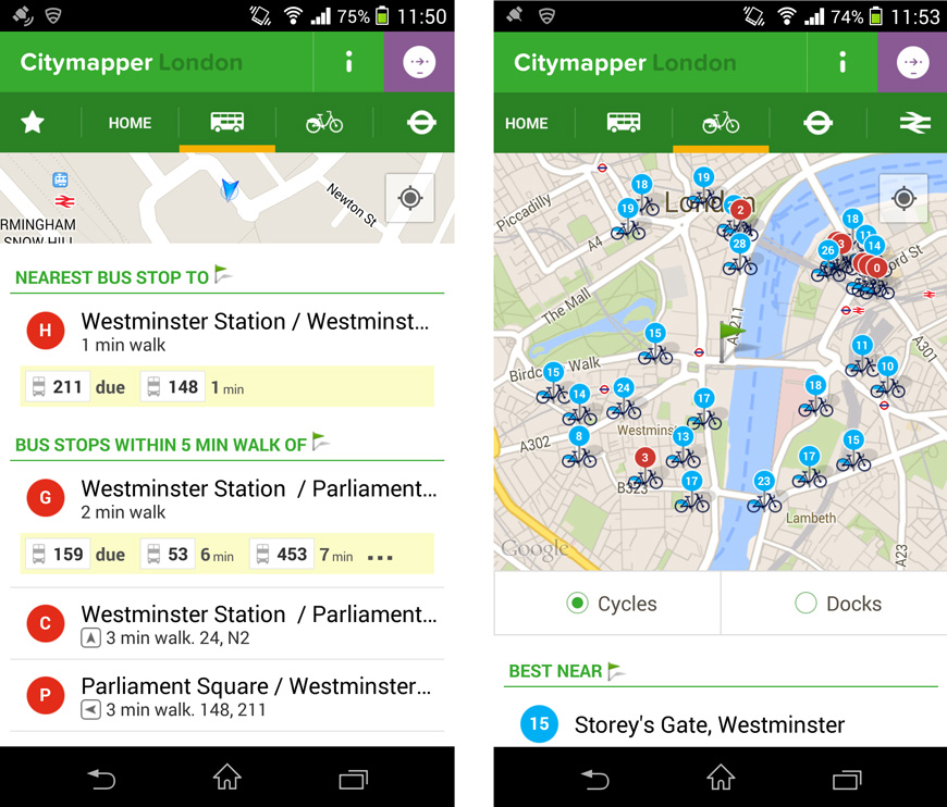
An example of an app which provides “Where my nearest?” services is Citymapper - although currently limited to specific cities. For example, in London it provides local bus stop locations, with real-time information on bus arrivals. It also presents information on local bicycle hire locations.
