Road Network Operations
& Intelligent Transport Systems
A guide for practitioners!

Road Network Operations
& Intelligent Transport Systems
A guide for practitioners!
The rapid market penetration of smartphones world-wide has provided a highly capable new platform for the dissemination of travel information and access to other services. It has also transformed consumer expectations – that the information they want should be immediately available. This has accelerated the concept of Open Data – where data that is collected at public expense is made available to anyone to use – stimulating a market in, for example, traffic and travel information applications. (See Open Data and Case Study: Open Data UK) Car manufacturers have also responded to this trend, offering various ways of linking smartphones to vehicle audio equipment and visual displays.
Standards and standardised solutions are not available in all cases where applications rely on proprietary systems or smartphones to disseminate or collect information. Developers face the potential market challenge of working with multiple (non-standardised) development platforms.
Navigation and route guidance systems use satellite-based positioning and digital maps to offer drivers a selection of routes to their destinations. Drivers enter their destination and any route preferences – such as shortest distance or quickest route, or one avoiding toll roads. The system calculates the optimal route and provides instructions via screen displays or voice synthesis. Positioning is handled by:
Navigation systems originated as on-board and dedicated handheld devices – and have been developed to include on-line tools (such as access to traffic images from CCTV cameras on the motorway network) and real-time traffic information. The data was made available to mobile navigation systems using digital broadcasting – Digital Audio Radio (DAB) or (in Europe) incorporation of RDS/TMC traffic information codes. (See Basic Info-structure) Traffic data was displayed to the driver – or used to support automatic route re-calculation if sufficient congestion appeared along the route during travel (“dynamic route guidance”). (See Urban Traffic Control)
Today’s navigation systems include all of these options – and have built on them further by leveraging one and two-way wireless communications and cloud technologies in a variety of on-board, off-board and portable devices. This means that data storage, computing and location-finding may be powered by in-vehicle resources or by the cloud – which greatly increases the availability and functionality of navigation systems. (See Navigation and Positioning)
The new capabilities allow map providers to update maps much more frequently. It also enables map data to be combined with many other sources of static and real-time location-related information that may be helpful for travellers. For example, a navigation application on a smartphone may offer multimodal journey options – driving, public transport and walking – allowing users to decide on their departure time based on timetable schedules and driving time estimates.
The user interface in navigation systems has also improved over time. It is critical for safety that the use of navigation tools creates minimal driver distraction. Head-Up Displays (HUD) – which project information directly onto the windscreen – mean that drivers do not have to look away from the road to look at a screen embedded in the vehicle dashboard. The deployment of HUD solutions was initially limited by cost – but an increased number of vehicle manufacturers are either offering, or planning to offer them, in the near future. Augmented Reality (AR) systems – which provide location-specific information in a visual form overlaid onto digital maps – are also expected to be more widely deployed in the next few years.
Navigation systems typically select the quickest or shortest routes based on speed limits and travel distances. It is generally possible also to select routes for fuel-efficiency and reduced emissions, or other variables – such as the number of cross-traffic turns (which typically require longer engine idle times, and use more fuel). Fleet companies are early adopters of this approach to eco-routing – because it delivers significant fuel cost savings. Eco-routing also benefits electric vehicles – enabling them to achieve greater driving range distances on a single charge.
One of the key challenges to electric vehicle adoption is ‘range anxiety’ – a concern that the vehicle will run out of electric power in an area without charging facilities, leaving the driver and passengers stranded. This has stimulated the market to develop applications that provide information about the nearest charging locations and in some cases allow travellers to make advance booking at a charging station.
There has recently been a surge of activity in the consumer market – with original manufacturers’ equipment (OME) being installed and aftermarket devices (such as black boxes and alcolocks) becoming available. Their deployment is encouraged (or required) by insurance companies – in return for reduced insurance premiums to provide an incentive to develop good driving practices. The insurance community in Europe and the USA has been particularly active in this way – but projects are underway in many other countries as well, including South Africa, Japan, and Australia. (See Data Capture)
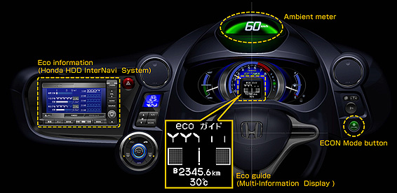
Eco-driving applications provide information about the impact of a driver’s choices – with the aim of encouraging driving patterns that are more environmentally sustainable. For example, some vehicle displays show fuel efficiency in real-time in response to driver acceleration and braking – as shown in the illustration below - In the future, a “connected” eco-driving solution might:
(See New Forms of Mobility and Smart Vehicles)

These types of applications may in the future be integrated into systems – enabling: