
Road network monitoring technologies are there to enable effective operations, incident detection and traffic management. Without a real-time view of the road network – gathered from sensors or other data sources – road operators would not be able to detect incidents, optimise traffic plans, inform the development of long-term upgrade and new capacity plans, or confirm the effectiveness of investments made.
The most cost effective data gathering strategies use existing detectors, sensors and other trusted sources. Most of the time, routine monitoring of static detectors provides the main source of traffic data but if an incident is detected other sources may become more important. For example, voice reports from a police officer at the scene of an accident can help optimise the most appropriate response. Other data sources that are used in network operations to influence traffic behaviour include weather monitoring stations (temperature, visibility and wind speed), ice alerts on bridges, and notifications of roadworks by utility companies or lane closures for road repairs.
Different vehicle and traffic monitoring applications provide different (but complementary) views of the road network. For example:
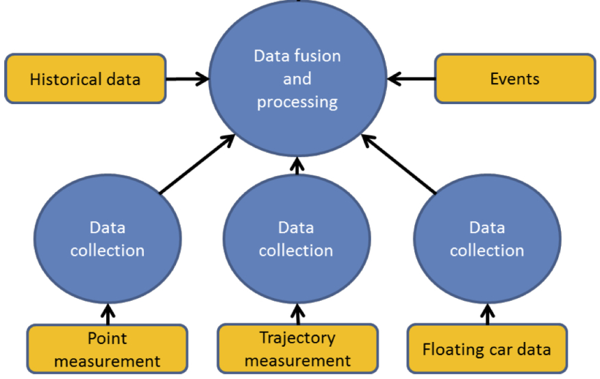
By combining different outputs, it becomes possible to automatically alert road operators to unusual patterns that could indicate that an incident has occurred. The figure below summarises the general data collection methods available.
Traffic condition and travel time monitoring. Reproduced by permission of Easyway (http://www.easyway-its.eu.) a trans-European project co-financed by the European Commission.
The key sources of data, the technologies for their collection and methodologies for their analysis include:
Vehicle detection is a critical enabler of traffic management, network monitoring and incident management. Examples are: the operation of signalised junction, variation in speed limits on managed motorway schemes, triggering red light cameras and controlling barriers,. In many cases, road users are unaware of vehicle detection systems but they do experience their effects. Vehicle detection is also an essential tool for incident management and traffic count surveys – and may complement reports from emergency services and other manual reporting sources.
Detectors may also be categorised according to where they are mounted:
Vehicles may be detected in a number of ways:
Vehicle detectors and sensors commonly used for traffic monitoring include:
CCTV cameras are often used as a substitute for inductive loops in some applications and when interpreted by computer can provide valuable information to road operators about traffic flows, incidents, local weather conditions and the presence of pedestrians and animals. Images can also be used to derive information on speed, occupancy and traffic volume. It is also one of the main sensor technologies for Automatic Incident Detection (AID). (See Automatic Incident Detection) A typical CCTV-based detection scheme consists of cameras installed on masts, each having a roadside cabinet, located on the edge or the median of the road. The topography of the road network dictates where cameras should be located (and their height) - to ensure some overlap of coverage zones. Camera separation for AID is likely to be denser than for general surveillance.
Point sensors and cameras are used for incident detection and warning as well as for the daily management of the network:
There are advantages and disadvantages to using the different types of detectors:
In the urban environment, buried inductive loops are inexpensive but require on-going maintenance to ensure that a significant proportion remain operational. Above ground detectors may be more appropriate instead.
For remote locations, the cost of providing power and communications for detection equipment and CCTV cameras can be high, particularly if the security of the camera sites and communications cables cannot be ensured. In these circumstances, solar-powered sensors or cameras equipped with cellular radio modules can be used. Limited light (particularly in winter months) and variable radio coverage may mean that these installations are equally unreliable.
Cameras with overlapping coverage can increase the resilience of the camera network. When combined with Automatic Incident Detection (AID) and other sensors, a comprehensive view of the traffic network can be progressively developed. This can be expensive. (See Vehicle Detection and Probe Vehicle Measurement)
The data gathering process can capture information that, when used by itself or when combined with other data, would be regarded as ‘personal information’ in some countries’ legal frameworks, raising issues of data protection and privacy. (See Legal and Regulatory Issues)
The basis for traffic management and incident management is the monitoring of real-time traffic conditions by probe vehicles and other sources. The systems aspect of ITS is increasingly complex, combining hardware, software, and communications to provide transportation services (See Managing ITS Implementation).
Communications networks are critical to the timely gathering of data and its distribution between operational systems, their functional components and road users. The communications layer of a system architecture is concerned with the accurate and timely exchange of information between different system components that support transport solutions. (See What is ITS Architecture) Common to many of the resources and activities of a Traffic Control Centre (TCC) are:
To ensure that a TCC has a comprehensive and continuous view of the road network, the communications services must be reliable. This means that they must be available most of the time and have the capacity to meet the requirements of applications. Ideally each interface should comply with publicly available communication standards that are supported by a competitive network of suppliers - to ensure that the communication architecture can be expanded.
Data communications are needed for the transmission of voice, video camera images and other data from CCTV cameras, traffic detectors, weather stations, emergency phones and tunnel monitoring systems. Communications also play a central part in distributing data for the management of the highway. The most common forms are:
The communication architecture identifies devices, roadside controllers, intermediate communication hubs and equipment needed at TCCs. A well-designed architecture allows expansion - such as the addition of more CCTV cameras (including high definition cameras), detectors located on other roads and voice and other data services.
Careful management of the communication network and its security is needed to maintain the performance of the communication links and to protect investments in communication systems. The communication network will also need to support the distribution of advisory and mandatory instructions to road users, such as Variable Message Signs (fixed and mobile) and Highway Advisory Radio (HAR) or other control signals. The communication network specification must to be designed with this in mind.
An effective traffic management operation relies on effective communication between agencies. This is not always fully achieved due to differences in organisational responsibilities and the lack of open, non-proprietary communications protocols that are in use – often because available standards-based interfaces have not been adopted.
The sensor equipment (such as loops, CCTV cameras) and the applications they serve, will determine the communication requirements and may be restricted by limited bandwidth. Typically, the data is collected and uploaded to a central location. For instance:
Communications using Internet Protocol (IP) television and Voice Over IP (VoIP) systems and components support road network management based on multi-media services, and are becoming more common. Standards are necessary to enable interoperability across interfaces. Ideally, equipment installed on the roadside should comply with standards for ‘field-to-centre’ communications – such as those standards authored by the NTCIP (21xx, 22xx and 23xx), Directorate-General for Mobility and Transport (European Commission) (DATEX), ISO (TC204), CEN (TC278) and the Transport Department of China (JT/T-series standards).
CCTV cameras are a common means of monitoring traffic and keeping track of incidents. Digital CCTV with image processing software can also be used to measure traffic flows, classify vehicles and to detect, verify and manage incidents. For example, in some parts of South Africa they are used to detect 80-85% of all incidents occurring on main roads. As a means of monitoring a road network the value of CCTV is unparalleled because it provides control centre operators with visual confirmation of an incident.
In general, CCTV cameras are distinguished by having either analogue or Internet Protocol (IP) communication interfaces. IP cameras may suffer from image compression (such as MPEG-4) but offer more flexibility when designing and scaling a CCTV system. If high-resolution IP cameras are used, the communication network capacity must match the data output demand of each camera – and this is potentially as high as 4Mb/sec. Otherwise the cameras need to be specified to balance image quality with frame rate. Some cameras have the capability to be configured to reduce their image quality and image reporting frequency.
As the road network expands, so does the need to manage it better. Deployment and use of technologies and equipment that detect vehicles and capture other dynamic data can help. The capture, analysis and interpretation of this data lends itself to computer-based processing enabling the state of the network to be easily understood. The information that is produced by the data aggregation and analysis function is fundamental to managing road networks. (See Operational Activities)
The benefit of data aggregation and analysis increases with coverage of detectors - potentially extending into other regions that are the responsibility of other traffic authorities. Traffic management operations on travel corridors that include national roads, secondary routes and municipal routes, could benefit from traffic operators sharing sensor data, traffic reports and interpreted data.
There are many types of detector technologies which have different levels of accuracy, reliability, update rates and data content. The process of data aggregation and analysis provides filtering, error compensation, normalising and fusion with other data streams – to provide a picture of the status of a road link or the road network, which is useful for road management.
The purpose of data aggregation and analysis, otherwise known as Data Fusion is to estimate or predict traffic characteristics – such as current/future/mean vehicle speeds, vehicle classifications and their volume – as well as environmental information and other topics of interest to travellers.
A distributed network of detectors will provide a more accurate view of the state of the road network than is possible from information captured by a few detectors. Sophisticated analysis can:
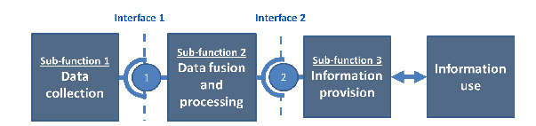
Data aggregation and analysis relates to Sub-function 2 of the Functional Architecture of a service – as shown below. There are many different approaches to aggregating real-time data in order to predict traffic conditions and provide journey time information. In general they include data validation and certification. The result is a measure of the Level of Service (LoS) of the monitored route. (See Monitoring and Evaluation)
The Information Chain. Reproduced by permission of the EasyWay Consortium (http://www.easyway-its.eu) a trans-European project co-financed by the European Commission.
The most common traffic variables can be extracted by considering all types of detectors, fixed and mobile – and include:
Additional data may include historical traffic data, details of planned events, road closures and diversions.
Data aggregation and analysis depends on a network of measuring devices (static, mobile or a combination of both) and probe vehicle measurements. The process takes account of the characteristics of each type of detector to estimate the traffic state of the network.
Measured data may need to be pre-processed to correct for known errors, measurement bias and availability, and to update rates (data age) and coverage (small or large area). Typically, the methodologies used are:
It may be necessary to progressively refine the measured data and to include additional sources – in order to improve its accuracy and trust in the data. Generally this process involves:
Traffic condition and travel time monitoring. Reproduced by permission of the EasyWay consortium (http://www.easyway-its.eu.) a trans-European project co-financed by the European Commission.
The analysis of data collected from a distributed network of sensors can be extended beyond simple detection of vehicles to predict congestion, to refine the timings of signals in urban traffic control systems or to detect incidents. For example, a breakdown in the flow of traffic would be indicated by rapidly reduced flow rates and by an imbalance between detectors located before and after an incident.
The quality of traffic information based on a network of different sensor types and their configurations depends significantly on the quality of the data received from each measurement device or system.
Each measurement technology has its own characteristics, including its accuracy (how often its measurements are close to the truth) and its reliability and availability (the proportion of time that the device is working and able to provide data reliably):
the device might have an on-board internal clock – which may:
The data aggregation process may need to fill in missing data, adjust for time offsets, and eliminate the effect of known faulty readings. The objective is to derive an accurate understanding of prevailing traffic conditions. At the same time the process needs to be sensitive to anomalies that might suggest an incident. For example, a CCTV camera can compensate for the failure of another if the cameras are placed so their coverage of the road network overlaps. Similarly, measurements based on probe vehicles can complement static detectors and extend the measurement coverage of static detectors.
In many regions, CCTV has provided the main source of traffic data to operators. As the CCTV coverage increases, the use of Automatic Incident Detection (AID) becomes a valuable tool for traffic officers - as a specialised form of data analysis that extends the capability of manual operators.
The process of data capture may include information that, when used by itself or when combined with other data, would be regarded as ‘personal information’ in some countries’ legal frameworks - raising issues of data protection and privacy. (See Legal and Regulatory Issues)
Traffic patterns become more complex as a road network grows to meet demand or improve access. Higher levels of congestion on some parts of the road network mean that unplanned incidents can have an influence outside the immediate area of the incident. This can result in greater risk to human safety and economic loss. (See Traffic Incidents)
Automatic Incident Detection (AID) use computers to continuously monitor traffic conditions and detect incidents or traffic queues. Road networks equipped with a variety of detectors and CCTV cameras provide the basis for automated continuous monitoring. The detectors are deployed to provide speed, occupancy and flow data to assist with traffic operations. Their output can be used to alert control centre operators to unusual traffic conditions and to detect incidents much more quickly than by manual methods – and so manage them more effectively.
It has been estimated that for every minute saved in detecting incidents, verifying them, and clearing them – another five minutes are saved in recovery time. The use of AID can also improve road safety by enabling a more rapid response to the victims of accidents within the critical first hour, otherwise known by the emergency services as the ‘golden hour’.
Incident management involves the implementation of a systematic, planned and coordinated set of response actions and deployment of resources to prevent accidents in potentially dangerous situations and to handle incidents safely and quickly. They are a critical component of a decision support system for traffic operations on the urban and interurban road network and its infrastructure of bridges and tunnels. (See Incident Response Plans)
At the heart of Automatic Incident Detection (AID) are filters and algorithms programmed to scan and automatically recognise a variety of patterns. The operators can validate the incident using conventional methods such as CCTV cameras and information from other sources, such as reports by the police and emergency services at the scene of the incident.
AID systems use the available detector data and image streams from road sensors and CCTV cameras to continuously monitor traffic conditions for patterns that indicate that an incident may have occurred. When the system detects a potential incident, it can alert traffic operators to commence the Incident Management (IM) process and implement pre-programmed responses to warn drivers and others. AID provides an effective means of improving incident detection. It complements manual monitoring of a road network since it can detect incidents quickly (often within a few seconds) and is able to monitor more video streams than a manual operator.
The most common sources of primary data for AID are in-vehicle inductive loops and CCTV cameras although there are a large range of other technologies that may be used. (See Vehicle Detection) The equipment (sensors and CCTV cameras) is used for both incident detection and the daily management of the network.
AID depends on the interpretation of information (vehicle occupancy, speed and traffic volume) captured from the network of traffic detectors. The Incident Detection Algorithm (IDA), often used in combination with AID, should be responsive and accurate - with a low error rate - to ensure that the AID system is trusted. Typical IDAs that depend on a network of discrete traffic sensors include:
Whatever algorithms are chosen, they will need to be calibrated and matched to the available types of sensors. It can be advantageous to simultaneously use multiple IDAs that have complementary characteristics – or apply different IDAs to different scenarios. To ensure accuracy, the data from individual sensors needs to be filtered before it is used by the IDA. (See Data Aggregation and Analysis) When an incident is detected, operators can draw on additional information from other sources such as CCTV cameras – and apply their own judgement to manually validate the incident.
IDAs can be applied to existing video streams. The IDA is either integrated within individual CCTV cameras or applied to a group of cameras to permit discrete events to be detected, such as stopped vehicles – as in the image below, debris, and vehicles driving erratically or in the wrong direction. Video-based AID detects events visually anywhere within an image - not only in the driving lanes but also on hard shoulders and emergency refuge areas regardless of the road surface material (concrete, asphalt, gravel or metal).
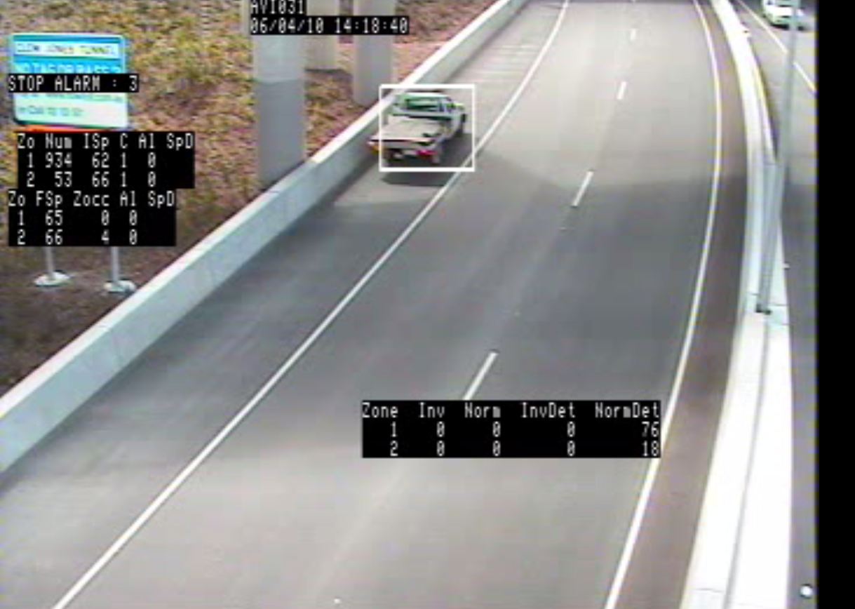
Stopped vehicle detection – interurban highway
AID depends on there being comprehensive coverage by sensors and/or CCTV cameras of the road network to be monitored. The accuracy and geographical reach of AID can be improved if additional sensors and cameras are deployed.
Traffic sensors installed for surveying purposes or for general traffic monitoring may not be suitable for AID for various reasons (loop systems may detect traffic presence but not changes in traffic speed, existing CCTV cameras may not have image processing capability). In most cases additional sensors will be needed to ensure the reliable detection of incidents. (See Vehicle Detection)
Images taken from a CCTV camera dedicated to AID can be used to provide reliable information on occupancy, flow and speed - whilst also serving its primary purpose of surveillance - enabling an operator to validate an incident reported by the IDA.
For a CCTV-based AID strategy there are a number of issues to consider:
For night-time conditions or where streetlights are unreliable, thermal cameras are effective at detecting vehicles on verges, or pedestrians and animals on roads. Thermal cameras also perform better in foggy conditions - so are useful for simple traffic monitoring.
Whether existing or new cameras are deployed, pre-recorded video of incidents can be used to test the performance of an AID system under different conditions, typically described by three parameters:
If hard shoulders are designated as normal travel lanes on a part-time basis (“hard shoulder running”) then an AID system, as part of a Decision Support System (DSS), is necessary to ensure the safety of road users. For example, if an incident is detected on the hard shoulder during hard shoulder running, approaching vehicles need to be alerted and the hard shoulder closed automatically or under manual supervision.
Excess traffic demand may cause a breakdown in traffic flow that results in the formation of queues and increases the risk of vehicle collisions and other incidents. An IDA function needs to be able to detect unusual queues, compared with normal traffic flows – adjusted for time of day, the day of the week and holiday periods.
Legacy networks of CCTV cameras can support AID - although a video decoder will be needed to prepare the video for computer analysis. Depending on the manufacturer, many legacy CCTV cameras, including those with a PTZ function, can provide video to support an AID function. It is likely that existing cameras have been positioned for surveillance – and may not be suitable for the image processing required by camera-based AID. They will need to be repositioned to ensure high detection accuracy and to remove the effects of light reflection (from vehicle headlights, wet road surfaces, low-level sunlight).
Inductive loops buried beneath the road surface or passive roadside detectors are able to provide a comprehensive view of traffic flows on the road network - but the impact of traffic conditions on individual vehicles can be difficult to understand. Detecting an identified vehicle as it passes through known locations on the network can serve as a “traffic probe”.
Probe vehicle monitoring is emerging as a critical technology that complements static sensors, CCTV cameras and ad-hoc reports, whilst also providing information on the speed and flow of a road segment. Road network monitoring is traditionally provided by static detectors such as inductive loops and CCTV cameras located on strategic roads with the highest volumes of traffic. (See Vehicle Detection) This is supplemented with ad-hoc reports from the police, emergency services and members of the public, which contributes to the development of a comprehensive view of the roads (including secondary or tertiary roads) – but the cost of monitoring a large area is often prohibitive.
Probe vehicle monitoring is where a vehicle is equipped to track journey time - for example by tracking Bluetooth signatures between successive points or by using in-vehicle navigation (GNSS). Speed and point to point journey time data is stored and communicated back to the management or control centre to:
Probe vehicles can generate more detailed information on the impact of traffic conditions – by providing the data to calculate, for example:
A probe vehicle must be capable of being reliably and uniquely identified at more than one discrete location. For example:
Roadside-based detection technologies make it possible to detect the same vehicle at different locations on the road network so it can be used as a traffic probe. The vehicles must have a specific identifier - such as a readable number plate, a Radio Frequency Identification (RFID) tag, or vehicles carrying a device (such as mobile phone, satellite navigation system, computer or portable media device) with a Bluetooth transceiver that is discoverable. Probe vehicles can also be categorised as “passive” or “active” - although sometimes this is an arbitrary distinction:
The techniques of Probe Vehicle Measurement have developed to ensure that any data collected is combined to create average road link performance and is not personally identifiable.
The most common technologies for probe vehicle monitoring can be split into roadside-based detection and mobile device reporting. Examples include:
Satellite-based in-vehicle systems are often integral to fleet management applications for freight and commercial operations. These vehicles often travel along strategic highways and can be a suitable for a fleet of probe vehicles to cover the network. (See Freight and Commercial Operations) Satellite technology can also be used for road user charging. (See Electronic Payment)
In general, the greater the number of probe vehicles, the better the quality and accuracy of the information that is derived. Small samples of probe vehicle may not deliver high enough accuracy on a specific road or for a specific road network. The behaviour of a single vehicle (such as a bus) may not reflect the general traffic flow – so it is important that the probe vehicles are a high enough proportion of the total to meet the required levels of accuracy.
A study by the Washington State Department of Transportation (WSDOT) suggested that sample sizes as low as 45 RF-tag-equipped probe vehicles per day – with average 30-minute headways - could yield useful data on the occurrence, duration, severity, and frequency of congestion. Probe vehicle sample sizes varied depending on local road networks, traffic patterns and other factors.
Increasingly, road users are being informed about road network conditions, before and during trips, through social messaging and third party navigation systems. They may receive traffic reports from other sources such as public radio stations, mobile phone alerts (Twitter, Weibo or other social messaging sites) and third party navigation applications. Traffic authorities can monitor messaging services such as Twitter (South Africa) and Weibo (China) for traffic information that may help complement static vehicle detectors.
The provision, collection and use of data from road users raises legal and institutional issues relating to privacy, data collection, ownership and sharing. (See Legal and Regulatory Issues)
Static detectors and probe vehicle measurement provide complementary views of the performance of the road network through roadside observation and by passively monitoring individual vehicles. These techniques are adequate, most of the time, for managing traffic operations. AID can improve their effectiveness in responding to accidents and planned events. Other sources of data that can help better manage a road network include:
During an incident, the mix of traffic data available to road operators is likely to change, with increasing amounts of information arriving from both reliable known sources (“trusted”) and unproven (“untrusted”) sources. Some of the information received may conflict with current knowledge - potentially highlighting a change in circumstances or new and unrelated incidents. The effective use and management of all data sources is critical to effective network operations, particularly during the incident management process.
A well-designed cost-effective traffic management operation needs to recognise the existence of other data sources and to provide the means to include them in its traffic and incident management strategy. Data sources and data owners, other than the highway authority or road operator include:
The figure below shows the role of other parties alongside road operators in the traffic data collection process. By way of illustration:
Whatever the source of the data, it needs to be assigned a level of trust by the road operator to help it prioritise sources and ensure that the reliance placed on a specific source is appropriate. Data sharing agreements between organisations should clearly specify each parties’ respective roles and responsibilities – and be formally documented (perhaps in a Memorandum of Understanding) and agreed by all parties. The road operator will also need to develop a policy and procedure for handling reports by the public – and to record this for its staff in an operations handbook.
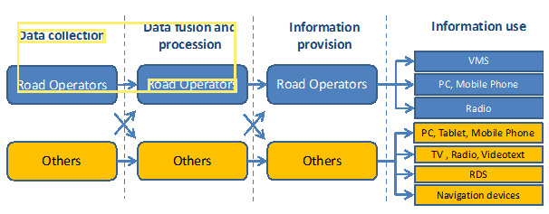
Organisational Model and the relationship with other parties. Reproduced by permission of the EasyWay Consortium (http://www.easyway-its.eu.) a trans-European project co-financed by the European Commission.
The variety of other data sources available is matched by the variety of data formats and the trust that may be placed on the sources. The most cost-effective data sources for developed and developing countries are existing sources – but it is important to check that they are reliable and suitable if they were designed for another purpose (such as a weigh-in-motion sensor). A rigid definition of sources may not be relevant – and a traffic operator will need to apply discretion and judgment to the value of the reports received from them. Whatever the source, all data collected needs to include as a minimum - location information and a time stamp.
Where additional information is needed to improve traffic operations or incident management, site observers may be deployed to specific locations to collect survey data, report on traffic behaviour at planned events or to provide real-time information by voice (mobile phone or private mobile radio) or handheld computer at the location of an incident.
Standardisation of data formats, protocols and communications interfaces is desirable to avoid misunderstandings or conflicts between organisations – such as the data provider (a Police Incident Control Centre) and the data receiver (the Traffic Control Centre – TCC).
If a data interface is required, a technical interface standard can help ensure that a TCC can add new sources easily - whether the data is provided from another system (Centre to Centre, C2C) or directly from a device located in the field (Centre to Field, C2F). Examples include: