
ITS-based traveller information systems are designed to give accurate information on traffic and transport service conditions so that travellers and fleet managers can adjust times, routes and modes of travel accordingly. Drivers can be advised to change their planned route to avoid incidents, congestion or severe weather conditions (based on historical as well as real-time current data). Public transport users can be informed about delays to services and available alternatives. Those users willing to change their mode of tranport can be provided with alternative travel options, recognising that choices may need to be made some time in advance of the actual time of travel.
The internet, mobile phones and navigation devices can also be used to provide people with directory information and access to other location-related services. These traveller services are often developed collaboratively between the public and private sectors. Travel information is, in fact, the doorway to a whole new generation of commercially viable, value-added, traveller services developed by private sector service providers.
There are many viewpoints on traveller information. The relevance of information changes as we progress through a journey. It is important to recognise that the level of detail needed changes, depending on the user and where they are in their journey. For example, information about which platform a train departs from, is unlikely to be of much interest several hours on from when the information was needed.
Traveller services can be divided into four distinct types:
Pre-trip information is vital to ensuring users of transport networks are informed of the choices available, and any pre-existing conditions associated with the transport networks concerned. ITS traveller information applications that can assist the traveller prior to their journey include:
En-route information is important to keep travellers informed during their journey to provide the opportunity for making informed decisions about changesIt may or may not be possible to make a route or mode change at any particular point, but awareness of likely delays is a significant benefit to the traveller. En–route ITS traveller information tools include:
Location based services, which make use of GPS receivers and accelerometers within mobile phones are an increasingly important component of traveller services. These include:
These location based services are increasingly making use of data from a variety of sources - and many services provide several of the functions listed above.
There is an ever increasing role for social media and crowd sourced data within Traveller Services. They provides an important platform to disseminate information about delays and disruption on the transport network - and allow users to communicate with each other and with the transport authority. Correctly used, they can be a powerful tool.
Pre-trip information covers all travel related information that travellers need - in advance of making their journey. Travellers need to understand:
Good quality pre-trip information enables travellers to make informed decisions about their journey, so they can optimise their route and minimise their costs, travel time or environmental impact.
In certain situations, pre-trip information has been used as a network management tool. A good example is the London 2012 Olympics where the online journey planner incorporated predetermined capacity limits on certain routes.
The proliferation of the internet and the mobile internet has transformed the provision of pre-trip traveller information. Less than 20 years ago the main sources of pre-trip information were road and street atlases and printed railway and bus timetables - supplemented bytelephone information services. Increasingly these sources of pre-trip information are being replaced by services using the internet, mobile internet and social media.
Provision of pre-trip information via the internet provides benefits to travellers as well as information providers - enabling more timely provision of information and its delivery to the users at home, in the workplace and for travellers on the move - at relatively low cost. The low cost and ubiquitous nature of this information has greatly increased traveller expectations on availability, timeliness and accuracy of information - and this is a critical consideration when designing information systems.
The key platforms for providing pre-trip information ITS services include:
The mainstakeholders in providing pre-trip information are:
The nature of pre-trip information provision is affected by the institutional framework within which they are deployed. In some cases a city authority may be responsible for fulfilling all the roles itemised above - for example, in London, the public transport operator, road network manager, and public transport network manager roles are provided by Transport for London. This organisational framework makes it is easier to mandate the public transport operator to provide known service disruption information.
Pre-trip information can be a vital tool for the road network and/or public transport operators. In the case of a major disruption to the network, it benefits everybody to have information disseminated on the state of the network - and the otpions open to users. If a public transport operator cancels services, informing the travellers about how they can complete their journey helps to reduce stress, complaints and compensation demands. For a road network operator, pre-trip information can reduce network congestion in a region around closed network links. For example, by providing advanced warning to travellers about road closures due to snow, travellers can choose to change their route or their mode of transport - so minimising congestion on alternative routes and in the vicinity of the closure.
Pre-trip information needs to be tailored to the needs of users and the delivery channels they tend to use. A 'one size fits all' approach is often inappropriate - so care must be taken to ensure that consistent, but targeted messagesa is provided to each audience type.
Provision of fares and journey information for public transport journeys is a particular challenge in de-regulated environments - where public transport operators are not mandated to provide details of schedules & pricing policies to network managers or regulators. This can limit the level and quality of information that can be provided - to avoid this it is important to ensure early engagement with public transport operators.
The internet provides an excellent opportunity to present information and to allow users to interact with it. Many transport authorities and operators have taken advantage of this to connect with current and potential travellers and help inform their decision making on transport journey options. The growth of internet-based journey planners has sometimes been at the expense of other forms of communication.
The key benefits of internet journey planners include the ability to present, what may be a complicated transport network, in a simple, user-focused way. When this is well implemented, it can break down barriers to travel, but to do so it is essential that the information presented is accurate and correctly maintained. This is often a significant challenge and should not be underestimated.
Increasingly much of the underlying mapping data, may be provided as an open data source, reducing the cost of maintenance of this part of the service.
Journey planners on the internet can be categorised into two main types: single-mode journey planning and multi-mode journey planning.
Single mode journey planning includea:
Road based journey planners - such the AA Route Planner for the UK and Europe enable a road journey by car to be planned from door-to-door, with a list of printable instructions and directions - and maps. Additional features such as the approximate cost of fuel can be determined for any given route; and many include station to station rail journey planning - for example Deutschebahn in Germany and SBB in Switzerland. Information on fares, ability to transport bicycles, availability of food and disabled access may also be available. Some companies are also trialling applications which let users choose their service - based on current or predicted level of over-crowding (See Real-Time Journey Information). These enable certain the users to select their own preferences - whether it is to enable selection of an emptier train for a journey, or planning a road journey to avoid low bridges. (See Freight and Commercial Vehicle Operations)
Traffic information websites, may not provide a direct journey planning function, but they may provide access to information to support journey planning - such as information on known current congestion, roadworks and road surface condition.
Multi-modal journey planning has been explored by many public transport authorities as a tool for promoting modal shift. There are also a growing number of private providers who use data provided by public authorities to develop value added journey planners.
Most multi-modal journey planners allow journeys to be planned for road transport, walking, cycling, or public transport with walking links integrated to show routes between public transport stops or stations. There are very few journey planners that fully integrate all modes and can provide advice on mixed-mode journeys - such as car routes linked to public transport options.
One of the most ambitious attempts to provide multi-modal journey planning on a large-scale is the European Enhanced WiseTrip project for international journey planning. At city level, there have been, or are, a wide range of choices of journey planners developed and provided by private and public operators - ranging from the (now discontinued) UK national journey planner, Transport Direct, to regional or city-based services such as CityMapper for London and New York). Many provide real-time and en-route services.
Phone-based journey planning pre-dates the Internet. Services can be divided into public transport advice and road condition advice.
Generally, public transport phone journey planning requires the public to ring and speak to an advisor to generate a personalised journey plan. Road condition advice can be obtained from many road authorities via an automated phone system - with the 511 services in the US being the most well known. Automated traffic information phone services often present the same information that is also available on traffic information websites.

Taveline Telephone Services in UK
Road based telephone traffic information services can be easily automated - and in some cases, the user is provided with an automated menu system to search for traffic information on specific roads. Other authorities may provide a general customer care line, which can provide traffic and incident information alongside other services - for example, the Traffic Scotland Traffic Customer Care Line. Once again, internet-based services has tended to reduce the usage and value of these services - for example Highways Englandhas discontinued provision of its Automated Traffic Information Phone Line, providing the information instead via its website, mobile applications and social media feeds.
A whole series of ITS applications are necessary for internet journey planners, traffic information websites and phone services. Jurney planners will collect information from a variety of sources - some static, some dynamic. It is important to ensure that each information element is:
Single-mode road based journey planners require:
Road based journey planners may be able to accommodate live and planned traffic event information and show the impact of this information on journey plans - by displaying them or using them to inform estimated travel times.
There are various international standards associated with traffic information data exchange. Traffic and event data may be available from multiple sources - and it needs to be considered at the outset how this data will be incorporated into the service. Traffic data exchange within Europe is often distributed using the Datex2 standard. (See ITS Standards) The USA has a National Systems Architecture Framework (See ITS Architecture) and associated data exchange standards. To integrate data on traffic delay and events, consistent definitions of event, their consequences and delays need to be applied. Many of these parameters are defined in Datex2 and other standards. There are numerous technologies used to collect road traffic data and information - which are used as enabliung technologies to inform the development of journey planner applications (See Enabling Technologies). Network and event data should always be geo-referenced using appropriate international geographic definitions - generally, WGS84 or Latitude/Longitude metrics.
Multi-modal journey planners require - generally, in addition to the functions for single mode road journey planners:
Public transport schedule information needs to be sourced from the public transport operators, and may be added manually or be electronically imported into the journey planning software. In Europe, Transmodel is the European Standard reference data model for public transport. Data exchange standards generally exist for public transport schedule information transmission - such as VDV-452 in Germany and TranXchange in the UK. The public transport access node definitions are also often standardised - for example IFOPT, NETEX. (See ITS Standards)
Real time data can also be integrated into multi-modal journey planners. In Europe this real-time public transport data exchange is defined in the SIRI- XML standard.
There are key parameters which impact on out-turn journey plans. These need to be given careful consideration (including their impact on the user interface design) - for example, the system may limit the number of changes to a journey, or this may be a user-defined parameter.
It is also critical that, when specifying and designing a journey planner, that the potential data sources to be integrated are considered at the outset - together with the implications of processing the resulting data (especially where real-time information is included).
When developing a journey planner it is worth bearing in mind that, in the future, other journey planners may wish to query your planner. Data exchange standards for journey planning requests exist - including Journeyweb, Delfi and EU Spirit. (See ITS Standards)
The key trends in journey plannner design are the amalgamation of more sources of data and the desire to make these more open and integrated with cycling journey planners and carbon calculators. Many authorities are also publishing data for third parties to integarte in their own applications. There are increasing moves to incorporate real-time information on road traffic and public transport information with planned and unplanned events, into all types of journey planners.
The European Union’s 7th Framework Research project ‘WISETRIP’ has been trialling integrated pan-European public transport journey planning. Other areas of research include more detailed development work on accessible journey planning - Transport for London has commissioned work from the Loughborough University of Technology into this.
In the UK, the NAPTAN data standard defines the public transport stop. For each bus stop, multiple pieces of information must be collected to ensure logical journeys can be presented later on. This should include accessibility information and interchange times - within, and where applicable between, transport modes. Hierarchies of information need to be planned carefully and consideration given to adoption of an architecture - for example, Transmodel, the European Reference Data Model for Public Transport.
Pre-trip and en-route radio travel advice and guidance are particularly hard to disentangle. (See En-Route Information, Radio) The key issues with the distribution of traveller information by radio and television are selecting which information is disseminated- and targeting it at the correct audience.
Television is used to deliver traffic and travel information via:
In the internet age, generally the content for text-based travel information services is identical to that provided for internet traffic information - but its presentation may be different depening on the bandwidth available for information broadcast and transmission/retrieval.
When considering broadcasting TV bulletins, the content is generally constrained by the length of time slot available. Traffic and travel bulletins are often presented before and during key commuter times - and focus on planned and unplanned events with significant impacts. When considering TV bulletins it is important to take into account that traffic and travel items of wider interest, may have longer air times impacting so how these traffic and travel segments are put together.
The key to providing the correct content for bulletins is being able to clearly categorise traffic and travel incidents and effectively scripting the traffic broadcast - to create an interesting and behaviour changing travel news item. Specialist companies exist in most mature markets to assist with traffic news collation and scripting of broadcast items for radio and TV.
Pre-trip traffic and travel information delivered by Radio can be categorised as :
Dedicated traffic internet radio services are radio services which can be played by running an application in an internet browser or on specific internet radio hardware. These radio broadcasts consist of a looped programme of short duration containing significant traffic (planned and unplanned) incident information. A good example is the The UK’s Traffic Scotland service.
Internet radio services includes a codec - to code/decode the radio transmission, which is streamed over the internet. Various audio codecs are employed, although the Internet Media Device Alliancec is trying to standardise these and has published the IMDA Automotive Profile 1 - which specifies requirements for in-car internet radios including the transport layer and codecs to be used.
Traffic Information is also presented in conventional radio programmes - and is most often heard on the approach to, and during, peak commuting times. These broadcasts are contained as a segment, often as an add-on to news broadcasts - in a similar way to weather forecasts - and this applies to both internet radio, DAB and analogue broadcasts. The key requirement is for the travel bulletin to be focussed on the needs of the audience - and, in the same way as TV, needs to be interesting to all listeners (as far as practicable). The most severe incidents with the greatest impact should be the highest priority for broadcast. Traffic incident severity and impact should be determined and associated with the incident in such in a way that enables multiple reuse of the information.
Traffic information can also be distributed as a non-audio data stream (over radio). (See En-route Information)
Internet Radio
It is important to consider that the listener is unlikely to want to listen endlessly to Internet Traffic Radio - so broadcasts should be relatively short and regularly repeated to maximise their value to listeners.
Traffic/Travel Radio Bulletins
The key requirement for bulletins is that they are focussed on the needs of the audience, and - in the same way as TV - they need to be interesting to all listeners (as far as practicable). The most severe incidents with the greatest impact should be the highest priority for broadcast.
A lot of work has been undertaken to standardise the categorisation of events - such as the Alert C standard ISO 14819:2013 (parts 1 and 2) which defines event categorisation for RDS-TMC, and also the Datex 2 information exchange standard which is primarily for Transport Management Centre to Transport Management Centre communications. (See Network Monitoring)
For FM analogue radio - overlays for traffic announcements and definition of programmes containing traffic information are defined by the Radio Data System (RDS) components Extended Other Networks (EON), Traffic Announcements (TA) and Traffic Programmes (TP) for which more information is available on the RDS Forum.
Structuring and prioritising traffic and travel event information is the next issue to address as a key requirement - making consistent data dissemination a much easier prospect.
Travel information kiosks are electronic kiosks in public areas for the presentation of travel information. They may contain:
Kiosks may be funded by the Highway Authority, Public Transport Operator or Commercial Providers. They may be interactive or non-interactive - and located internally or externally. Interactive Kiosks can be touch screen or include a keyboard and tracker ball to enable the user to navigate between pages - and they may also include a printer to provide 'takeaway' information.
Considerations include:
The key issue, when designing and specifying kiosks, is the purpose for which they will be used. This informs specification of requirements. For example - if the kiosk is intended to enable the user to plan an immediate local public transport journey from the location of the kiosk, the default setting should enable the user to select the destination and confirm an immediate travel requirement. For popular destinations, this could, with careful design, require only two screen taps or mouse clicks.
It should be recognised that there is always a trade off between simplicity of use and functionality. Optimising the balance between them is the key to success.
Kiosks form part of the built environment - so their physical form and the design language need to be in tune with their construction and the information they present. For example, kiosks may be an integral part of a city wayfinding system - in which case a consistent design approach is necessary to make the wider wayfinding strategy successful.
Data requirements must be considered when designing a kiosk and its user interface. As with all traveller information, it is essential that the information displayed is correct and timely.
Many interactive kiosks may serve a dual purpose - with, for example, a default screen which provides real-time service information on public transport or road congestion. When a user interacts with the kiosk, they may obscure the screen for some time - so user dwell-time must also be considered during the design phase. If it takes the average user 5 minutes to retrieve the information they require, they will obscure the kiosk display for that length of time. This highlights the importance of understanding the use cases - and optimising the interface design - to maximise the value of the kiosk.
Historically, en-route travel information consisted of a paper map or instructions on how to reach your destination. It was not possible to communicate disruption or delay information to road and public transport network users with the exception of verbal communication from public transport network staff or the emergency services (Police, Fire, Ambulance).
Today, in contrast, there is a myriad of information available to drivers and travellers via:
This diversity brings challenges in terms of ensuring data accuracy, quality, timeliness and interpretation. These issues are discussed more fully under each of the tools below.
Increasingly the road traveller and public transport user is demanding greater knowledge of the entire network. This trend is expected to continue with a greater requirement for predictive information and real time advice in the event of network disruption.
As technology evolves we also see a requirement for managing existing information services with a falling user base, while new services take over. The public expects the existing services to continue in a seamless manner unless advised otherwise. There is a clear requirement to manage expectations and set clear timescales for any required migrations.
The key objectives for providing or receiving en-route information are dependent on the users/stakeholders concerned.
the priorites are:
the priorities are:
Keeping service users informed during both times of normal operation and disrupted operation is becoming ever more essential for transport authorities and operators. When transport authorities and operators do not provide this information the absence of information will be filled by users sharing information on social media, which may or may not be accurate. (See Social Media & Data)
For en-route information, the mobile internet has become a key source of traffic and travel information. Traffic/Travel information and journey planners can either be provided as a mobile website or as a mobile app (application). Mobile applications are downloaded onto the phone and then run, whereas a mobile website is viewed in mobile browser.
The decision on whether a mobile website or mobile application is required is subjective and it depends on the type of information to be conveyed and the level of interactivity and processing required. For traffic and travel information it is critical that the user interface is simple and clear, with an easily navigated menu structure.
The Highways Agency in England has a mobile internet site. It enables users to drill down through a series of menu options to see the current traffic situation and live incidents. It also enables a view of motorway traffic flow by means of colour-coded arrows which show current speeds between junctions. (See figure below.)
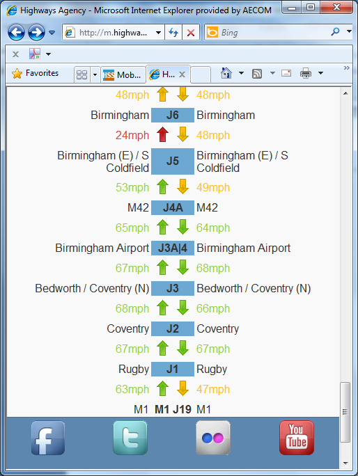
Highways Agency (England) Mobile Internet application
V-Traffic in France provides a sereis of Apps for traffic information. (See figure below). Separate Apps are available for the most popular mobile operating systems (Apple's iOS, Google's Android and Microsoft's Windows Phone).
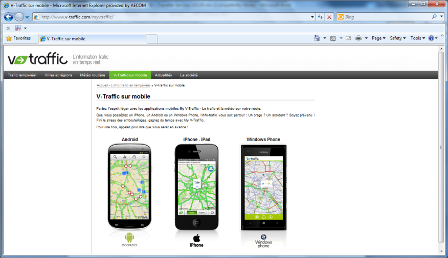
V-Traffic Mobile Applications
The key elements to consider in Traffic and Travel information app or mobile website must be:
Human interface design is critical in such applications and care must be taken to consider the menu structure to allow access to salient information as easily as possible. (See User Centred Design )
Multi-modal journey planning is also available via mobile apps and websites and increasingly applications that provide real time updates while en-route are found.
A good example is the Guardian Angel service provided in Münster Germany.
Mobile applications for Iphone, Android and Windows phone are provided and the application enables the user to plan their journey which seamlessly includes real time updates of public transport services. If service disruptions occur on route then the application will replan the trip on the fly and advise the user of revised service connections.
When specifying mobile internet sites and applications it is vital to ensure the mobile site(s) or application will operate on phones or tablet computers of the target audience. The most popular operating systems currently in use are:
Web Accessibility Standards for users with a disability should be considered in the design stage.
Many public transport operators now offer Wi-Fi internet access on their services. In addition, mobile coverage continues to improve across both urban and rural locations.
So-called “Big Data” has opened up a whole world of information which can be accessed on the move. A large number of service providers (such as Transport for London in the UK) provide access to their real-time data for applications and websites so that this may be utilised in a variety of methods. Google Transit and CityMapper use this data to provide an integrated service covering all aspects of a cities transport. Delays, incidents and other problems can be instantly reported and changes to pre-planned routes or an alternative, unaffected route can be suggested to the user.
However, there are also sources of data open to those without smartphones. A range of text services and .mobi sites enable all users to access some level of current real-time information on the running of the network, including such data as expected arrival time of buses, known delays to the network and roadworks or vehicles accidents which may cause problems for public transport and motorists alike.
Other applications or apps available utilising such data are numerous and offer a range of services for public transport users. One such example is Moovit, an Israel-based application company which has provided a system enabling users to report on the level of crowding on public transport services, in addition to other factors such as the cleanliness, comfort and (on a bus) the driver’s performance. Over the long-term, using these reports, a picture of which services are busiest (and should be avoided by the space-conscious commuter if possible) is built up and factored in. San Francisco’s BART system and the Netherlands’ Rail Network are utilising similar applications, with the Dutch using historic loading data to indicate the level of over-crowding on some trains.
This webpage is best read in conjunction with advice on use of radio and television for trip planning. (See TV & Radio )
En-route Traffic and Travel information delivered by Radio can be broken down into the following sub-groups:
Highway Advisory Radio are dedicated, usually local, radio stations broadcasting traffic and travel information and information on points of interest. Very often the traveller is advised of these services by the use of static signs next to the Highway network. Such services are common in the USA. In the USA these Traveller Information Systems are licenced by the Federal Communications Commission and are generally low power AM stations. Elsewhere they are also used in Japan along major motorways (AM). In Italy and France similar services operate (FM). In the UK (England), the Highways Agency has experimented with both low power AM Highway Advisory Radio services for specific major events and also a full internet radio service. However these services have now been discontinued.
Internet Radio traffic and travel specific services are also used. The UK’s Traffic Scotland service provides an Internet radio service covering Scotland with a looped travel information broadcast. A National (all Scotland) broadcast is updated every 20 minutes at peak times and every 30 minutes at off peak times and regional Scottish content is updated every 30 minutes at peak times and hourly at other times.
Highway Advisory Radio provides an effective way of informing motorists of problems on their current route where static signage informs the driver of the frequency they need to tune their receiver too. A research report from CalTrans in the USA presents technical information and insight into factors to consider when locating AM Highway Advisory Radio transmitters.
Traffic and Travel radio bulletins, as discussed in the pre-trip section provides tailored traffic information in short bursts within other programming. The level of detail provided and relevance will depend in part on the target audience and geographic coverage of the radio station. Necessarily the wider the radio station coverage area the more selective the incidents presented must be and therefore the classification and selection of the incidents for broadcast is significant.
Broadcasts are often focused on ‘Drive Time’ associated with commuter peaks. Incident information presented should be short and clear with some descriptive detail, some impact assessment and if possible, some resulting travel advice. The message should be broadly consistent with other information channel outputs.
A Dynamic Message Sign (DMS) – is any sign or graphics board that can change the message to the viewer (text or pictogram). It may be a Variable Message Sign (VMS) or a Changeable Message Sign (CMS) where:
Dynamic message signs – and more specifically changeable message signs – have been around for many years. Initially these often were conventional road signs with rotating prism elements within, where 3 options of message could be chosen. These allowed simple diversion route strategies to be implemented or warnings to be issued at known problem locations, however this type of sign is limited in what can be displayed and also needs careful maintenance to ensure rotating elements do not seize up.
Developments in technology then led to the available of magnetic flip disk (or flip dot) signs to be developed where a sign is made up of an array of disks with one black face and one yellow retro reflective face and passing a current through relevant disks can switch the face of the disk displayed. This type of sign uses very low power consumption, but can suffer from disks occasionally sticking and may not be as clearly visible as LED of Fibre Optic Signs depending on the lighting conditions. Fibre optic signs have a light source and fibre optic strands which illuminate pixels or a simple image.
The majority of roadside DMS are now LED as these are generally reliable and flexible in operation.
Changeable Message Signs are used when either a warning is to be given for a specific hazard or behaviour or when there are only a limited number of options available. A good example might be a speed activated warning sign associated with a bend in the road. The sign is illuminated if a vehicle approaches at high speed. These type of signs can be used to support road safety campaigns and can be very effective in reducing incidents are specific accident prone locations.
Variable Message Signs are used for a wider range of purposes including:
A useful synopsis of Active Traffic Management experiences in the USA and Europe can be found on the US DoT Federal Highway Administration website.
The size of the sign required is, in part dependent on the speed of traffic on the link in question. The faster the road speed the larger the sign needs to be to display the same amount of information. In addition, on high speed roads, the amount of information that can be assimilated in the available time is small. In the UK approximately seven words can be displayed on the largest VMS signs on motorways which are 3 line 18 character VMS.
Portable Dynamic Message Signs are particularly useful at locations where a permanent dynamic message sign is not justified. This may be during medium term roadworks, for a specific event, or perhaps on a motorway with significant seasonal traffic demand. Pre-planning of the location for such signs is vital in order to ensure they can be safely deployed and retrieved. Increasingly such signs are solar or wind powered and in locations where such signs are periodically deployed, provision of hardstanding for these signs should be considered.
In Europe there are technical standards for VMS design that must be followed. In addition there are guidelines for the Principles of VMS message design that provide more detail on how and when it is appropriate to use VMS.
Public Transport information is increasingly presented via digital media. These displays include summary screens showing:
Care needs to be taken when considering the information to be displayed. Use cases should be developed to inform the design of both the display and the information to be presented. As with kiosk design, the following factors need to be considered:
The UKs real time information group has several pertinent standards related to public transport information displays, for example "Meeting the Needs of Disabled Travellers" (See: RTIGPR003-D002-1.8).
Users of public transport services expect information on:
It is vital that the display technology provides trusted, accurate, reliable and understandable information. Pre-requisites for clear information include:
Additionally it is helpful to be able to advise the latest situation regarding service operation – real time information and information related to interchanging between services or modes.
Latest developments with public transport and multi-modal signage include increased use of solar powered displays and the use of e-ink and similar technologies to reduce the power consumption of signs. There is also greater use of TfT Liquid Chrystal display technology as opposed to LED technology which provides greater flexibility to present multiple types of information which can maximise value from the displays concerned.
Satellite Navigation Systems include a routing engine - software that plans the route to the destination. In basic models the route is planned on the basis of a fixed database that describes the road network. (See Basic Info-structure and Navigation and Positioning) More sophisitcated models can take into acount current traffic conditions and provide information on:
Presentation of the information on-screen or by audio must considered in light of human factors and the underlying map interface - the "user interface".(See Systems Approach to ITS Design).
Traffic information can be coded and distributed digitally as a non-audio data stream over radio. This is how most traffic-enabled Satellite Navigation Systems receive traffic information in real-time. They can then display an icon in relation to the event, alert the driver audibly to it and also prompt the driver to re-route - or automatically amend the route accordingly.
When there is a traffic incident, congestion, or extreme weather event, a data message can be sent to the navigation device. Each event can be assigned a level of severity (impact) in terms of its geographic extent, timing and its likely duration. (See Traffic Incidents) Transmitting these details enables the satellite navigation routing engine to calculate a delay level for the location (the links and junctions in the network that are affected). The software then recalulates the travel time and route options, taking account of this additional delay. Regulations and traffic restrictions may impact on whether automatic re-routing is allowed.
In Europe and North America the main standard for transmission of traffic event data to in vehicle satellite navigation systems is known as RDS-TMC. Information on RDS-TMC can be found from the Traveller Information Services Association website including TMC coverage maps. A lot of work has been undertaken to standardise the categorisation of events, inparticular the Alert C standard: ISO 14819:2013 - parts 1 and 2 define event categorisation for the RDS-TMC digital transmission system on FM radio.
For TMC to operate there must be a location code table tied to the underlying map network. These location code tables can be developed privately or publically.
Gradually as radio bandwidth becomes scarcer, so it is likely that Digital Audio Broadcasting DAB will take over from FM Analogue radio services.
There is a more detailed standard for broadcast of traffic related data over DAB known as TPEG. Practitioners should be mindful of the TPEG standard (ISO TS 18234) for traffic and public transport incident information. This standard makes use of the additional bandwidth available via DAB and the Internet. TPEG is now being widely implemented on digital networks. More information on TPEG can be found via the Traveller Information Services Association website and more specifically in the Introductory Guideline.
Both RDS-TMC and TPEG delivery mechanisms allow for the transmission of incident, congestion and weather related messages with TPEG allowing a much richer definition of incidents.
Both TPEG and RDS-TMC can be delivered as open or encypted services dependent on whether these services are to be provided by Government or the Private Sector.
Such information is of particular benefit to tourists and those who are unfamiliar with the route/public transport in question. This may help prioritise where these systems have greatest value. Such systems must be derive information on the stops on the route and must know when these stops have been reached. Most often they are linked to other on vehicle systems, such as ticket machines or automatic vehicle location systems. (See Passenger Transport) It is critically important to ensure robust operation of such systems making sure that they can be automatically updated if the vehicle is moved between routes. As with other display types, the following must be considered:
Location based services are a rapidly growing component of traveller information services. Such services, made possible by the proliferation of mobile devices containing GPS receivers and 3 axis accelerometers enable easier journey planning and other information to be provided in the immediate vicinity of the user.
There are many types of location based services:
These and other services are constantly evolving. The more data that is made available to developers, the more opportunities there are for value added services. Critical to their successful growth - is the reliable delivery of data and confidence in its security and the security of mobile payments.
So-called 'Big Data' has opened up a whole world of information that can be accessed on the move. An increasing number of stakeholders (such as Transport for London in the UK) provide access to their real-time data for applications and websites so that it can be utilised in a variety of methods (See Open Data). Google Transit, CityMapper, and others use this data to provide an integrated service covering all aspects of a city's transport. Delays, incidents and other problems can be instantly reported - and changes to pre-planned routes or suggestions for alternative, unaffected routes, can be made to the user.
Journey planning is an important component of traveller services. A location-based journey planner application will automatically detect the location of the user, minimising the additional information that the user needs to input to generate their journey plan. Once the location is detected the user enters their destination and time/date for travel and the journey plan can be produced. Generally, with mobile applications, the journey plan is generated ‘off board’ within a central system - with the results communicated to the mobile device. Location-based journey planners can be single or multi-modal and may or may not include road based journey planning. (See: Journey Planning)
The public transport data needed to support a successful location-based application for journey planning needs toinclude the public transport network, stopping points and schedule information. In Europe, Transmodel is the European Standard reference data model for public transport.
Data exchange standards generally exist for this public transport schedule information transmission including: VDV-452 in Germany and TranXchange in the UK The public transport access node definitions are also often standardised. Examples include:
Latest developments in this field include mobile applications presenting the live locations of public transport vehicles. Upcoming developments include ‘augmented reality’ where mobile apps are expected to enable the user to point their mobile device at a public transport stop or vehicle to determine the destinations available from the stop or the vehicle. The challenge for transport stakeholders is to make the data available to support these enhanced services.
Other applications (or 'apps') available, that use this type of data are numerous and offer a range of services for public transport users. One example is Moovit, an Israeli-based application company that has provided a system enabling users to report on the level of crowding on public transport services - in addition to other factors such as the cleanliness, comfort, and the driver’s performance. In the long-term, these reports provide a picture of the busiest services (to be avoided by the space-conscious commuter), which can be integrated into the journey planner. San Francisco’s BART system and the Netherlands’ Rail Network are using similar applications - with the Dutch using historic loading data to indicate the level of over-crowding on some trains.
Location based services for real-time information are focused on providing details of public transport services or road conditions in close proximity to the user's current location. A good example is the NetNav App provided by Centro in the UK West Midlands. This mobile application uses GPS to identify the user’s location and present the closest bus stops to thatlocation as well as real-time departures from those stops. The App also contains a location-based journey planner.
The Hands Free Traffic Talker England service uses data from the Highways Englanbd to power its app - which uses GPS to locate the user and present a hands’ free audio service providing location-based traffic information.
The key requirements for these applications are:
A barrier to those wishing to use public transport services, is not knowing where they need to go to catch their transport service. “Where’s my nearest?” transport services aim to remove this by uncertainty by providing information on the nearest transport facilities. Historically these have been provided as pre-trip information (website or paper based media – such as “where to board your bus” paper maps) and as en-route information using paper, “where to board your bus” posters. Today, smartphones equipped with GPS or other location sensing technology allow this information to be presented at any location using an appropriate mobile application. In addition to public transport information, the location of parking spaces, taxis or car sharing vehicles can also be reported.
Ideally, multi-channel information should be consistent across all media - with the ‘Where’s My Nearest’ transport service applications using the same design style and mapping as other paper based and digital channels. This would mean that street wayfinding totems, public transport paper based mapping and where’s my nearest apps all have the same family 'brand'.
Emerging technology such as Wifi-sensing, Bluetooth or iBeacons (an Apple proprietary protocol using Bluetooth 3) seeks to provide more accurate location information suitable for location finding in an indoor environment. Thess could be used to provide guidance to the location of departure platforms, gates or stands in a large transport interchange, such as a railway station or airport.
Specially tailored apps or phones designed for people with disabilities can help overcome their difficulties in finding specific transport facilities.
A GPS chipset is generally now a standard feature of most smartphone handsets. This allows Apps installed on the phone to detect their location and present information based on that location. Thelocation is obtained from interpreting signals from multiple satellites. Generally the stronger, or more numerous, the satellite signals, the more accurate the location. Outside, in an open area, smartphones can provide a location accurate to a few metres. If the phone is located inside a vehicle or a building, or if there are large buildings nearby - the signal and accuracy of the location can be impeeded. The latest mobile phone operating systems including Android and iOS also use the presence of nearby wifi signals to enhance the accuracy of locations. The accuracy of a GPS signal is measured by the Dilution of Precision (DOP).
Typically, GPS alone, is not sufficient for providing wayfinding in an indoor environment - since the accuracy is not sufficient to provide detailed directional information. Transport operators wanting to provide indoor wayfinding may need to install additional equipment to provide extra signals that smartphones can sense to provide a more accurate location. Wifi and bluetooth hotspots have been used to do this and can be read by a dedicated app. More recently, the introduction of Bluetooth 3 Low Energy and iBeacons potentially offer a dedicated solution.
Often blind and partially sighted users need the most help in finding their way to transport locations. In the UK, the charity for the blind, the Royal Natkional Institute for the Blind (RNIB) has promoted key fob technology using short-wave radio called 'RNIB React'. In active mode, when a key fob comes into the vicinity of an RNIB React unit, an audio message is announced indicating where the user is, to aid wayfinding. Electronic bus stop signs have been incorporating these units to allow blind and partially sighted users to find their bus stop. The key fob also allows users to request further information by pressing a button on the key fob. For bus stop signs, this is often used to announce departure information from the stops.
Potentially, a smartphone customised for blind and partially sighted users could offer similar functionality, with a voice activated interface.
Increasingly, transport operators/authorities are making their data available to third parties, through OpenData Initiatives (See Open Data) to encourage developers to can develop apps or sites which provide location-based services.
One option is to provide an API – a software library that allows apps or websites to access data, using programming calls. Another option is the provision of a XML data feed. For instance, in Europe, there are a series of standards for exchanging transport data, such as DATEX (for highways data), SIRI (for public transport schedules and real time data), IFOPT (for public transport static data).
Those wishing to make data available openly need to consider the terms under which the data will be made available. Issues:
Static data, such as transport stop locations, is often easier to make available as it is infrequently updated. For dynamic data - such as real-time departure information, the volume of data can be substantial, particularly if there are large numbers of subscribers. Those wishing to publish data need to consider if they can handle these large volumes of requests and whether they need to charge an access fee to help offset server costs and internet capacity.
An example of an app which provides “Where my nearest?” services is Citymapper - although currently limited to specific cities. For example, in London it provides local bus stop locations, with real-time information on bus arrivals. It also presents information on local bicycle hire locations.

Citymapper App
Increasingly products and services are being purchased via the internet. Transport is no exception. Users expect to be able to purchase tickets online using Apps and Websites. Transport operators need to provide easy to use interfaces, that allow users to determine the most appropriate ticket, based on factors such as cost and time, and to purchase them online.
Delivery options will depend on the ticket types offered by the transport operator. If no electronic ticketing products are available (See Electronic Payment), then delivery to the user’s address or collection points at stations or travelshops will be required.
If other ticket methods are used such as print your own ticket or mobile ticketing, the user can generate their ticket at home. Mobile ticketing involves signing up and creating a ticketing account. Tickets can then be downloaded to your mobile phone. The phone is shown to the driver on boarding. The phone image includes a QR code which can be validated to demonstrate legitimacy of the ticket. For example, Arriva bus in the UK operates mobile ticketing.
The websites or Apps developed, need to be accessibleso that easy are use and compatible with screen-readers or other assistive technologies for those with sight or hearing impairments.
When developing e-commerce, the key consideration is theplatforms on which it will be available. Will it be available as a website, or on mobile devices as a mobile website or as a dedicated smartphone App (and if so, what operating systems shall it support)?
Web browser compatibility is an important issue - if the website does not function correctly in a particular browser it is likely to limit usage and create user frustration. It is important to test the website in the most common browser/platform/screen combinations. This should include mobile platforms since, increasingly, users are using these devices. For instance, the United Kingdom Gov.Uk website provides for compatibility testing. The aim is not to ensure 100% visual clarity but to ensure key information functions actually work.
It is important that eCommerce websites are intuitive and easy to use, particularly if customers will be using them regularly to purchase tickets. It is also essential that websites support accessibility functions - such as high contrast or screen readers so that those with sight problems can also access the site. The W3C Web Accessibility Initiative provides design techniques and guidelines for ensuring accessibility. It also includes a procedure for testing accessibility and its rating.
Websites must be secure - particularly to protect user personal information and payment details. The Payment Card Industry Data Security Standards provide mandatory security requirements for card payments.
Ticketing technologies are a major factor in e-Commerce. For instance, users with a Near Field Communications (NFC) enabled phone can potentially use a mobile phone app to purchase tickets and load their tickets onto their smartcard by tapping their smartcard against the NFC sensor on the phone. (See Passenger Transport)
Truck parking plays an important role in the movement of freight around the world. (See Freight and Commercial). ITS can play a vital part in a number of different issues related to truck-parking:
There are now several truck stop mobile apps of varying types for a number of geographic regions. Many provide a ‘where’s my nearest truckstop’ function with information on the nature of the parking and facilities available - including an assessment of security and services available. Most include details of the pricing of truck stops. Many allow drivers to log an online review of the facilities.
In Europe there has been a significant desire driven, by the European Union to improve the quality and security at truck stops and optimise the use of parking spaces. The SETPOS project was a trial programme to set new standards for secure truck parking throughout the EU, and to provide new truck parks to demonstrate standards. The aim was to improve driver welfare and security, as well as offer a secure location for freight whilst travelling on the Trans-European Road Network. All of these sites offered pre-booking as part of the pan-European network, so that drivers would not need to ‘bank’ driving hours in case their original choice was full. Currently, limited use is made of truckpark advanced reservations.
In the United States, the West Virginia Division of Highways (WVDOH), is adding truck parking guidance to its portfolioof ITS services. Parking space availability at truck parks is monitored using wireless sensors - and the information is relayed through either, roadside signs (See Roadside DMS) or through the State’s 5-1-1 Highway Information Service.
ANPR cameras can often be used to ensure both the identity of the vehicle as well as offering a route for charging for use of the truck park and its facilities. (See Electronic Payment).
From an ITS service perspective the key requirement is to have a clear and uniform structure for truck park classification and space reservation. In the EU the Label project, a successor to SetPos, has developed a truck park classification system with criteria and service levels for security and facilities.
Location-based tourist information is closely aligned to location-based marking and public transport and many apps provide a mixture of location-based services.
Location-based apps provide a mechanism to advise tourists of:
An example of a mobile application providing tourist information is the UK's Visit Bon which provides:
It is desirable for common design elements to be shared between the public transport and city/regional wayfinding systems and tourist information applications. Effective tourist information needs to be well targeted at the likely user - and this should influence the look and feel of the applications as well as the language used and information presented.
From a technical perspective, the critical requirements areto ensure that all data elements are correctly geo-refererenced, up to date, correctly attributed and rigorously reviewed prior to publication.
Marketing and tourist information is likely to contain advertising content - which offers the opportunity of revenue streams, but may raise regulatory issues depending on the funding source for the location-based service.
Location based marketing provides advertising or promotional information based on the user’s location. In the case of transport services, this might be during a transport journey or at a particular stop or station en route.
It is possible to create location based marketing with a Mobile App that automatically senses when a user has reached a particular destination but it is more common to get users to indicate they are at a particular location or “check-in” there, using the app.
One of the current most popular location based marketing apps (Foursquare) encourages users to check-in to a particular location. A leaderboard is established based on the most recent check-ins. Those at the top of the leaderboard are rewarded with special offers. For example, the Bay Area Rapid Transit Authority offers badges to those who check in at their stations. This has been reported to have improved patronage and customer satisfaction.
Social Media such as Facebook and Twitter also allow users to indicate that they have been at a particular location. This is commonly more used to provide brand awareness. Alternatively, location based marketing information can be provided to customers through a web link, which can be provided through a URL, tapping an NFC tag or scanning a QR code (See "What are QR Codes?" below).
Increasingly paper timetables at public transport stops are being supplemented with the use of such QR codes and NFC tags.
One of the challenges is the speed of technological development and the rapid proliferation of technology. The public transport authority or operator must decide whether to provide QR codes on printed material in addition or instead of SMS codes. Additionally they may consider providing NFC tags or possible ibeacons. An informed decision should be made based on the purpose of the interface, the approach taken to printed information and the prevalence of devices able to read the information provided.
Location based marketing can be delivered not only to personal mobile devices, but also to on-vehicle audio visual systems. This is especially relevant to public transport where an increasing number of trains and buses have audio visual screens installed.
In Karlstad in Sweden, when buses are in the vicinity of a well known fast food chain advertisements are played in between next stop information and announcements and disruption information (See http://geosignage.se/eng/disruption-information-and-location-based-ad/)
Near Field Communications is a short range communications technology, which allows RFID tags to be read using using radio communications. It is available in most recent smartphones but not on Apple iPhones. It allows data to be exchanged if the phone is presented to a NFC specific tag. Typically this is used to provide a web link to further information.

What are QR Codes ?
When users scan a QR code or tap a NFC tag it is important they are presented with the relevant site (mobile optimised) to obtain the content they expected.
Privacy concerns are important when develop location based marketing. Some users may find it intrusive to have promotional messages generated whenever they reach a particular location. An “opt-in” approach where users can opt in for this type or marketing is preferable. Also, practitioners should also limit the storage of user location data, if it is stored then it is clear what this data shall be used for and preferably, made anonymous. (See Privacy)
Social media differs from more traditional media types such as newspaper, radio or television by allowing users to generate their own content which they share with other social media users. Content is often either made public, visible to all or to a pre-defined network of other users.
The use of social media sites has grown rapidly. The most highly used social networks such as Facebook, Twitter, Google Plus, Linkedin, Instagram and Pinterest all have millions of regular users. The introduction of mobile internet sites and apps means that users can access information on the move, when they are away from home or work.
Transport operators are increasingly using social media as a way of interacting with their customers. A social media page can be a good way of providing information to a large number of users, offering promotions and engaging with customers. If done well, social media can be a cost effective solution: for instance a traditional telephone support service may get numerous calls asking the same question. Using a social media platform customers can see previous responses and need not ask the same question.
Social media also gives an opportunity for transport operators to work together, for instance promoting multi-modal offers or reporting disruption on linked services, such as a local bus service serving a railway station.
One of the key advantages of a social media is that for a basic service, only a web enable computer and browser is required. Organisations need to create a business account and then can start creating content. For a small organisation, an informal approach may be the most appropriate, where social media content is created when required on the platform. However, for larger organisations expecting to interact with a large numbers of users, a more considered approach is required. Social media authoring tools help allow content to be generated, often in advance to manage the workload required.
If disruption and service information is to be presented on social media, organisations need to consider whether this will be manually entered, which requires human input but may become overwhelming or resource intensive for a large transport network. The alternative is that existing travel information systems are adapted to provide feeds direct to social networks. Also depending on the network size, multiple feeds maybe required to provide the relevant information.

Real-time Information on Twitter
An emerging area is the potential for using social media to crowd source information. Crowd sourcing is where social networks are scanned for users reporting similar events. For instance crowd sourcing could be used to collect on information on traffic congestion. However, the reliability of crowd sourced information needs to be considered. Reliability of information improves as more people report the same issue but this may not provide sufficient information or a detailed enough location for transport management purposes.
Social media platforms provide analytic functions showing information such as the number of users, demographics, user location and participation rates. These analytics can give insight into the types of passengers carried by transport operators but it is important to remember that social media users may not be representative of users as a whole.
Access to social media accounts should be controlled using appropriate password security controls making sure that passwords are changed regularly. Unauthorised access could result in accounts being used to provide non-relevant information or inappropriate remarks which harm the reputation of the organisation.
Practitioners need to develop a social media policy to outline how they will use social media. Social media should be seen as complimentary to other means of communication with customers, such as phone services, internet and email. Although social media has high usage there are still significant numbers of people who do not use these services or prefer other methods of communication.
Topics to consider are:
These considerations will affect the staff resources required. Linked to this is whether staff will be available to respond, whether it will be 24 hours a day / seven days a week or only during operational hours or office hours. It is important to make users aware of this so they know what information to expect and when they can expect a response.
Practitioners should consider:
One option is to use multiple platforms. For example Twitter could be used to provide information on service disruptions, while Facebook or Google Plus are used to collect passenger feedback.
For social media to be effective, passengers need to be made aware of the channels available. These channels need to be advertised on transport vehicles, stops and stations.
Guidelines on tone and style for social media postings are important. Social media posts should be short and to the point, allowing users to decide quickly whether they are relevant to them. More detailed information an be provided over the internet or using other platforms, for instance detailed information on ticketing and alternative services during disruption could be provided on a link. Training may be required for staff.
Passenger complaints that arise on social media are best dealt with "off line" either using private messaging or alternative media. This is also to ensure privacy of both passengers and operator staff. Linked to this there should be a clear moderation policy on social media, so that offensive or inappropriate comments are removed.