

Until a decade ago urban and motorway traffic control systems were considered separately – both from a technical and institutional perspective. As traffic demand increases the need for a seamless transition between systems becomes more important. The need for integration is particularly acute in situations where there are heavily trafficked motorways, expressways and parallel arterial road routes. The demand for reliable real-time driver information systems continues to grow. Increasingly the control of traffic on urban streets can no longer be treated separately from highway traffic control.
The Integrated Corridor Management (ICM) concept is one of the most significant developments in integrating ITS functions and resources between different organisations. Motorway and all-purpose arterial roads operations are closely coordinated from a single Traffic Control Centre (TCC) – or a highly integrated (linked) set of two or more TCCs. The objective is to achieve an overall balance of traffic between routes that serve a common set of destinations. This involves balancing demand through signal control and pro-active use of driver information, coupled with traffic diversions in some cases.
Integrated Corridor Management is designed to operate the motorways and the arterial road network and to optimise the use of both. It applies especially to a corridor with similar travel routes, that are broadly in parallel, serving similar destinations. Ideally, a single TCC would manage traffic on both motorways and the arterial roads, so that operators can shift resources – and demand – from one roadway to the other as conditions require.
An alternative to a single TCC, is to integrate several local TCCs by sharing data, images, information and decision making. Their managers will need Traffic Management Plans and Standard Operating Procedures (SOPs) that address balancing traffic along the corridor and managing traffic when an incident occurs. (See TCC Administration and Traffic Management Plans) Closely integrated operations are particularly beneficial in managing planned special events where the road traffic uses both the all-purpose arterial roads and motorways.
Public transport (transit) management is often an important element of network control – where for instance one or more bus and/or multimodal rapid transit stations are located within the managed corridor. In general though, purely transport operations (such as vehicle dispatch) are managed from a separate public transport operations centre. (See Operations & Fleet Management)
Freight customs clearance demonstrates the use of ITS in selected corridors. This could be a road freight or heavy goods corridor or a trans-continental or country-to-country corridor such as Mexico to Canada (via the USA) or Nicaragua to Panama (via Costa Rica). (See Freight Enforcement)
Planned events have a significant impact on Road Network Operations. They include sporting events, concerts, festivals and conventions taking place in permanent multi-use venues (for example – arenas, stadiums, racetracks, fairgrounds, amphitheatres and convention centres). There also include less frequent public events such as parades, fireworks displays, bicycle races, sporting games, motorcycle rallies, seasonal festivals and milestone celebrations at temporary venues.
Five categories of special events can be identified based on their characteristics:
These are all different forms of traffic incident and often require major planning for traffic management, preparation and response. They are distinct from other incident types in a number of important respects – one being that they involve a new set of stakeholders that do not play a part in most other types of incidents and emergencies. They include:
Planned Special Events can have a significant impact on travel safety, mobility and journey time reliability across all the transport modes and roadway facilities. Managing travel for these events involves:
Events such as the London Olympic Games require considerable planning. Traffic lanes dedicated to vehicles carrying competitors to their events were introduced, a command and control centre was established and additional roadside hardware was deployed (mainly VMS and vehicle detection equipment) – (See Case Study: London 2012 Olympics)
The practice of managing travel for Planned Special Events should target the following objectives:
The goals of managing traffic and travel for these events are as follows:
Traffic Incident Management (TIM) is the response to traffic accidents, incidents and other unplanned events that occur on the road network, often in potentially dangerous situations. The objective is to handle incidents safely and quickly, to prevent further accidents and restore traffic conditions back to normal as quickly as possible. It requires the deployment of a systematic, planned and coordinated set of response actions and resources.
Traffic Incident Management proceeds through a cycle of phases starting with immediate notice of possible dangers or problems ahead – as soon as an incident occurs – in order to forewarn drivers and prevent accidents.
Incident warning and management have two main goals – to:
Incident management requires planning, a response that is proportionate, safety at the scene of the incident and recovery. It requires attention to three main aspects – in order of priority – safety, mobility of traffic flow and control and repair of damage.
To understand how control strategies and network operations can reduce the negative impact of incidents, it is important to understand the timeline and different stages of incidents, as shown in the diagram below.
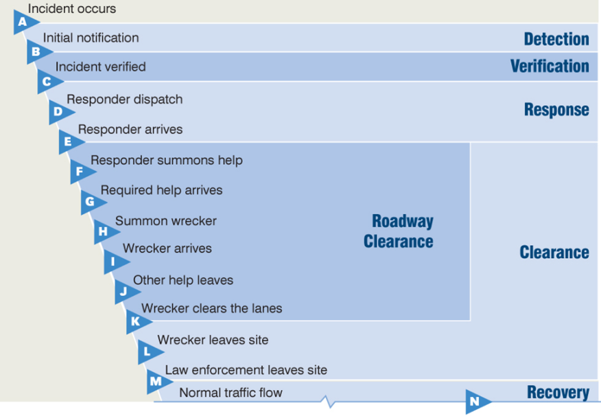
Timeline for a Typical Traffic Incident - Source: Wallace, et al., 2007/2009 - Note: “wrecker” is an American term used to refer to “recovery vehicle or team” or “breakdown truck or tow-truck provider”.
The diagram might represent a collision on a motorway, a spill of materials or a disabled vehicle - resulting in the need to close one or more of the running lanes. All steps will not occur in every incident - and there may be other interwoven relationships – but the diagram represents the typical sequence for most moderate-to-serious incidents. The steps are shown in a staggered fashion simply to illustrate that the incident timeline is not uniform (the time increments are relative – and not to any scale).
The duration of particular stages in the incident are represented by the letter pairs in the diagram and are listed below. For example, the duration of the incident itself would be from point A on the timeline to point M, while the total time the incident is having an effect on traffic is from A to N – with the time elapsed to point N often proportionately much longer than shown.
Common phases of an incident are:
Although not evident in the diagram, the recovery period is frequently longer than the duration of the incident itself. Incident recovery can be four-to-five times longer. This means that for every minute that can be trimmed off incident detection, verification and/or clearance, up to 5 minutes of recovery time can be saved for traffic to get back to normal.
Avoiding secondary incidents is of paramount importance because they start the incident response cycle all over again. The aerial photograph below illustrates this point. The original incident that caused the multiple vehicle pile-up was a car that was stationary due to its engine overheating – which blocked a traffic lane in the direction going “downstream”. The stationary vehicle was the cause of one or two collisions but many more collisions on both sides of the highway occurred because a vehicle responding to the incident attempted to bypass the traffic queue and reach the incident by travelling the wrong way on the opposite side. The example shows that secondary incidents can in fact be more serious than the original incident.
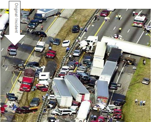
Secondary crashes resulting from a "wrong-way" (contra-flow) response - Source: Wallace, et al., 2007/2009, originally from the collection of John O’Laughlin.
All agencies must work closely together to quickly detect an incident, and to verify, respond and clear it in as timely and efficient a manner as possible. ITS in general and the Traffic Control Centres (TCCs) in particular will play a part at each stage. (See Urban Operations and Highway Operations) The emphasis must be on the rigorous application of the 4-Cs of incident management (Communication, Cooperation, Coordination and Consensus) and close inter-agency working, through Traffic Incident Management (TIM) teams. Traffic Incident Management Teams and Safety Service Patrols are vital elements of a good traffic incident management programme. (See Incident Response Plans)
Clarity in assigning roles and responsibilities to the Traffic Incident Management (TIM) Team, the Mobile Safety Service Patrols and tow-truck providers during traffic incidents cannot be understated. Even though the TIM team may not be an active participant in the response to a particular incident, it has a key role to play in formulating the policies, practices and training that go into it. TIM members will include the first-line responders or organisations that provide direct support. Mobile Safety Service patrols and tow providers are also active participants. (See Mobile Patrols)
Typical use of ITS devices and the roles and responsibilities of the TCC and Mobile Safety Service Patrols are summarised in the two tables below for different stages of an incident. In these tables there is no implied sequence of actions within cells – instead they are typical actions that might be taken.
|
|
Roles and Responsibilities |
||
|
Incident Stage |
Use of ITS |
Traffic Control Centre |
Mobile Safety Service Patrol |
|
Detection |
|
|
|
|
Verification |
|
|
|
|
Response |
|
|
|
|
|
Roles and Responsibilities |
||
|
Incident Stage |
Use of ITS |
Traffic Control Centre |
Mobile Safety Service Patrol |
|
Roadway Clearance |
|
|
|
|
Incident Scene Clearance |
|
|
|
|
Recovery |
|
|
|
|
After Action |
|
|
|
Protection of personnel and field equipment from vehicle impact is of primary importance during any traffic incident or on-road emergency. Use of high-visibility vests or uniforms by incident response teams and maintenance workers should be mandatory. High-visibility markings on response vehicles and maintenance trucks helps to avoid collisions. Buffer zones around incidents or maintenance work create a safety zone – although care needs to be taken to balance safety with keeping roadway capacity available for traffic flow. Standard practice differs considerably from country to country and local practices should be followed where they exist.
All means of travel and traffic information can be used to provide timely and accurate information to travellers about the nature and location of incidents and maintenance activities (See Travel Information Systems). Automatic Incident Detection can support queue protection warnings to the approaching vehicles up-stream (See Automatic Incident Detection).
Several innovative initiatives have been used in Europe and South America, as follows:
The responders’ first priority must be the safety of themselves and the people involved in an incident. Incident scene management, particularly on high-speed roadways, often involves closures of lanes and discussions about when to re-open lanes to allow traffic to pass an active incident scene.
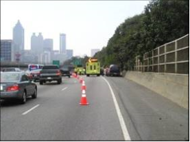
Creation of a Safe Zone around the incident. Courtesy Georgia DOT.
These decisions will be made by the incident controller (commander), who has powers to control and direct traffic (usually the police, highway or traffic patrol). ITS can assist with the decision making process. CCTV camera images – or the transfer of information from them – can be delivered to the commander either verbally or visually via tablet computer or a wireless mobile device – giving a “higher-level” view of surrounding conditions than available from the ground. Traffic and Travel Information is provided to inform drivers about lane closure status – enabling them to make more informed choices about making diversions or delaying or rerouting a trip. Less traffic helps ensure the safety of responders. (See Travel Information Systems)
Mobile Safety Service patrols play a vital role in safety. They help to manage the scene and alerting drivers who are approaching the back of the queue, help avoid secondary incidents as well as alerting passing drivers – improving the safety of the responders at the scene. VMS, Portable Dynamic Message Signs (in particular those mounted on Safety Service patrols) and other driver information delivery systems can help in providing a safe incident scene and protecting responders engaged directly in incident recovery. (See Use of VMS)
Many of the urban high-speed toll roads in South America have near total coverage by CCTV. This allows the TCC staff to monitor and record the entire response effort. These videos can later be used as a valuable training tool. CCTV also enables TCC staff to monitor upstream traffic to warn of any developing situations or to inform about secondary situations as they develop. (See CCTV)
It is sometimes difficult to determine whether a situation on the road will deteriorate into a major traffic incident or even a full-blown emergency. Some operational tasks for incident management described here may appear disproportionate to the number of incidents that occur. The crisis management checklists developed by the planning teams will help to optimise service, time and efficiency when an emergency occurs. If the impact of the incident is widespread several control centres may become involved in responding – and coordinated action will be needed. (See Incident Response Plans and Emergency Plans)
Work zones - due to road, bridge and tunnel construction and maintenance work have a negative impact on Road Network Operations. ITS and other techniques are used to minimise the negative impacts and keep traffic moving through affected zones as efficiently and safely as possible, for both for travellers and workers. This is especially important for night-time work, which is becoming increasingly common on the highways.
A number of measures are used to minimise worker exposure to motorised traffic and to safeguard road users from the construction and maintenance work. They include:
Safety cannot be achieved by preventive measures alone. It is important to constantly monitor the traffic situation, weather conditions and the specific construction or maintenance activities taking place – and respond as necessary. This can be achieved through the establishment of an integrated traffic management and construction operations centre. Often a dedicated operations centre with tow-trucks for incident response is set up.
In safe and stable traffic flow, traffic lanes must be observed so that proper segregation between vehicles of different speed is maintained. This can be done through the use of road studs, "cats eyes" or some other physical markers in the lane separation – which the driver will sense if the vehicle strays into a neighbouring lane. This may either trigger a warning or – in vehicles with advanced equipment – a warning could automatically lead to corrective action by the vehicle itself. Cameras or lasers, can be used to sense vehicle intrusion into closed lanes, which could otherwise endanger workers. (See Warning and Control)
ITS technologies provide many opportunities for monitoring and managing work zone operations – but are not a way of saving on fixed signing and traffic cones. ITS has benefits when signing and coning in preparation for roadworks – and when the roadworks are live and an incident occurs. A reliable source of power will be required, such as a portable generator.
ITS applications have been used to measure spot speeds in work zones. More recently APNR cameras are widely used to support average speed enforcement – with good compliance. Other ITS technologies are used to collect data that accurately reflects travel conditions through work zones – and, more recently, real-time monitoring of traffic conditions.
Use of ITS in work zones is not limited to urban areas. Temporary ITS devices, such as Portable Dynamic Message Signs (PDMS), Highway Advisory Radio (HAR), trailer-mounted cameras and sensors – can easily be deployed in a rural work zone where permanent ITS does not exist. Several commercial companies provide services that may include these devices, which communicate their data and images to a remote location where they are monitored (along with images from other locations). If issues arise, those monitoring the cameras can contact local law enforcement and transport officials who are able to respond.
In summary, ITS technology can be applied in work zones for the purposes of:
Many applications serve a combination of these purposes to:
Some regions have automated enforcement in work zones. The data and information necessary to support enforcement action can be collected from the use of Bluetooth, CCTV cameras, buying third party data and coordination with the TCC.
Most work zones are relatively short-term in nature, but some maintenance and construction work is long-term. Early deployment of ITS can be effective in supporting diversions, managing incidents and mitigating capacity reductions.
So-called “smart” work zones employ a combination of data sources to measure journey times through the work zones and are becoming commonplace in many countries. Real-time ITS supports a wide array of innovative applications that include active management of work zones based on observed traffic conditions. These capabilities are used to extend work hours and maintain acceptable journey times. Work is curtailed when journey times exceed certain thresholds. Work zone managers can be warned when travel speeds are dangerously high and a police presence may be needed.
In the UK work zone contractors have to limit their possession of the roadway for maintenance work during peak times. One innovative solution to this involves the use of Portable Dynamic Message Signs (PDMS) - with built-in traffic detection to monitor traffic demand. The ITS equipment allows the contractor to maintain lane restrictions longer – until the volume of traffic requires them to be removed. The increased time for site occupation allows longer work periods, improving productivity so that the works finished sooner. Motorists benefit from a reduction in the overall period of disruption.
Most emergencies are characterised as “short” or “no-warning” incidents or events, such as sudden major storms or other severe weather events, airline or train crashes, earthquakes, flash floods or terrorist threats. The less frequent, but usually more devastating events are “with-warning” emergencies, such as a hurricane, tsunami, tidal wave, flash flood, major river flood or spreading wild fire. The response to these different levels of emergency can be very different.
Having days to prepare for something like a hurricane or flood allows agencies to alert the public in a timely way, to stockpile or reposition resources, to muster additional resources and ultimately, prepare for evacuation. Emergency managers and responders can be more proactive in their responses.
When the warning is short, or non-existent, the response is almost entirely reactive. This is why Emergency Management protocols require extensive planning, preparation and training. Transport agencies are advised to be more involved in development of Emergency Operations Plans. (See Emergency Plans)
There are two aspects of primary concern:
When the transport system itself in not materially impacted – by a pandemic for example – the transport network becomes the focus of responding agencies. Roadways, public transport, trains, boats, ships and airplanes become the means of avoiding or evacuating from the emergency.
For traffic operations, transport managers can take the following actions to assist emergency managers:
When the transport network is directly impacted by the emergency it will be less effective in serving the emergency and its managers. This is where emergency pre-planning and preparation within the transport agency are so important.
In the USA, the Florida DOT and several coastal urban areas in this hurricane-prone state, stockpile traffic signals and generators in order to be able to replace damaged signals and to control restored signals in the absence of commercial power. Portable Dynamic Message Signs (PDMS) can temporarily replace damaged VMSs. Temporary Highway Advisory Radio units can be used for a similar purpose – but need to be supplemented by fixed signage that informs travellers of the HAR station frequency.
Effective communications is essential between Traffic Control Centres, Emergency Operations Centres and other centres where data and information about the emergency is collated (“Fusion Centres”) but not always fully achieved. Often it is because of differences in the jurisdictions of different transport agencies, emergency mangers and security people. Law Enforcement Dispatch Centres and Emergency Call Centres (999) can be included in the mix. In some regions this problem is exacerbated by the lack of open, non-proprietary communications protocols.
All can be connected by telephone and the Internet but co-location or direct electronic linkages for data, camera images and information sharing is more effective.
Extreme emergencies might require evacuation of residents and visitors, sometimes from large areas. Because of their extreme nature, a region can never be fully prepared to meet all of the challenges – both physical and institutional – that arise. From a traffic perspective, any evacuation is going to severely threaten the capacity of the transport network to handle it. Most of the actions that agencies can take to mitigate the negative impact of an evacuation and help keep traffic flowing require changes in the physical infrastructure or the use of mass-passenger modes.
Public transport (transit), school buses and trains can be used to transport evacuees, particularly those that are mobility-challenged – such as patients in hospitals and other health-care facilities, students, the homeless and prisoners. These arrangements take time to organise and carry out, and require good inter-agency cooperation. ITS can assist to a some extent – for instance by giving bus drivers the same traveller information that other vehicle occupants receive.
In urban areas, entire city streets can be shifted to one-way operation to accommodate large numbers of vehicles escaping harm’s way. These require large numbers of police or military officials to control traffic. ITS does not have a significant role here, other than to minimise the conflicting guidance that traffic signals might indicate (such as green displays in the “wrong" direction).
These can be deployed effectively to use the inbound capacity for outbound evacuating traffic. Emergency contra-flow lanes are often in rural areas. ITS can contribute through VMSs to reinforce contra-flow guidance, CCTV to monitor the traffic - and the provision of travel information to inform travellers. Most public information will be generated by the incident command centre. The increasing use of probe vehicles can give transport and emergency managers data on journey times.
In a few instances, devices such as motorway ramp-closure gates can be deployed for use in contra-flow operations. Normally motorway entrance ramps have to be closed to traffic.
The photograph shows a contraflow operation in Houston, Texas before Hurricane Rita in 2005. Contraflow requires a great deal of advanced planning, physical preparation (such as the cross-over lanes), large teams of officials for implementation, and time to deploy and later restore to normal. A number of USA states on the Gulf and Southeast Atlantic coasts - as far north as Baltimore – have Contraflow Plans, but most regard the measure as a last resort.
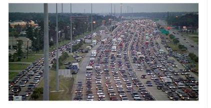
Courtesy Texas DOT.
Security threats are not very different to natural emergencies – except that they can have a broader range of impacts, such as cyber/Information Technology (IT) attacks, Chemical, Biological, Radiological, Nuclear and Explosive (CBRNE) threats and other terrorist actions. (See Network Security)
Much of the advice for emergency response applies to security threats – particularly in respect of threats to the transport network (for example the 1995 sarin gas attack on the subway in Tokyo in Japan and the 2004 train bombing in Madrid in Spain). The role of the transport network to respond to the threat is relevant – for instance, the closure of access to Manhattan Island in New York following the 9/11 attack on the World Trade Centre’s Twin Towers or when suicide bombers struck in Central London in 2005.
This supports the proposition for linking together Traffic Control Centres, Emergency Operations Centres and Information Fusion Centres. Emergency and security responders need to know the status of routes to and from the threatened area – both for responders and rescue teams.
A challenge to emergency managers is to avoid unnecessary evacuations. Following Hurricane Rita in Texas, the regional TCC’s (TranStar) spokeswoman, Dinah Martinez, said at a town hall meeting “During the disastrous Hurricane Rita exodus, part of the problem was that for every five people who evacuated, four of them probably didn’t need to." Traffic and travel information systems can be used as a tool to discourage people from leaving unnecessarily.
The opposite of evacuations is the confinement of people within an area – for example to contain a potential pandemic. In this case CCTV can show where vehicles are travelling when they should not be – and travel information can augment public safety notices.
Driving can be heavily affected by adverse weather conditions, such as heavy rain, high winds, dust storms, snow, fog and icy roads. It is important to inform drivers of extreme weather conditions in advance so they can change their travel plans or proceed with caution. Warnings on conditions that may be hazardous – such as high winds, icy roads or torrential rain – are especially helpful.
Road Weather Management (RWM) strategies provide:
For these purposes, supporting technologies include:
In adverse weather conditions, any intervention by the road operator must be implemented and co-ordinated efficiently to maintain the viability of the road network. In a flooding situation, for example, it is necessary to determine back-up solutions for the provision of driver information in the event of power or telecommunications failure. Procedures should include identification of areas at risk of flooding, the implementation of real-time monitoring systems incorporating threshold alarms and the specification of operations on receipt of alarm.
Post-emergency phases are equally important and include:
A successful RWM programme requires both prevailing and predicted weather and traffic information. The data required to derive this information needs to be collected from multiple sources. Many road authorities (as well as other industries) subscribe to commercial weather forecasting companies that provide timely, location-specific forecasts. They can do this because they draw their data from multiple sources, including the weather services – and integrate the results. Some have their own forecasters available on call to clients for consultation.
A self-evaluation and planning guide was developed, as part of an Federal Highway Administration study in the USA on integrating weather into TCC operations. The aim was to help TCCs evaluate their weather integration needs and develop appropriate implementation strategies. The guide assists the TCCs to identify weather conditions, weather impacts – and current levels of weather integration in the TCC and the need for enhanced integration.
In countries prone to severe winter weather, preventive action and crisis response may consist of handling both major disruptions to traffic (often lengthy) and frequent but brief disruptions due to weather conditions such as freezing rain, black ice or snow. The network management objectives will be to:
Winter service is based on data gathering (forecast and real-time), coordination, response and information dissemination. It requires a thorough knowledge of the network and its critical points, specific weather information, a sound knowledge of all stakeholders (such as weather forecasting services, suppliers of de-icing material), trained staff, equipment and materials (such as salt) – and good communication tools.
Traffic operations understandably deteriorate when there are inclement weather conditions. Automation of data collection of such conditions enables facility managers to respond to adverse conditions more timely and efficiently.
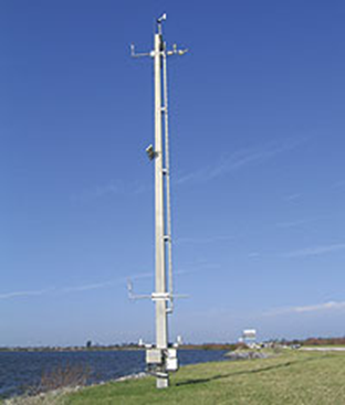
Source: http://ops.fhwa.dot.gov/weather/mitigating_impacts/technology.htm
A Road Weather Management (RWM) system (also known as Road Weather Information Systems (RWIS) and Weather Responsive Transport Management Systems (WRTM)) - consist of a set of sensors or Environmental Sensor Stations (ESSs) (See Weather Monitoring). These weather stations can detect and report a number of environmental measures that affect roadway operations, such as:
Perhaps the most common use of RWM is in cold climates and/or mountainous regions where snow and ice are commonplace. Maintenance operators use the data from strategically placed ESS units to determine the optimal time to deploy dispensing trucks for salt and grit and snow ploughs – and to determine the best treatment strategy – such as whether to use brine, salt or sand. This helps avoid premature or incorrect deployments, saving valuable materials and minimising vehicle operating cycle times, as well as reducing environmental impact.
Maintenance staff frequently use fleet-management systems to locate their vehicles, including where they have and have not yet ploughed or treated. In many regions, weather conditions can vary considerably from place to place. RWM may be used to help prioritise where and when to send equipment.
RWM technologies are also used to detect conditions that may be hazardous (such as high winds or flooding) – or that may impact roadway operations. Sensor systems are used to detect other conditions that cause reduced visibility – such as fog, smoke, blowing dust or sand and blizzard (white-out) conditions on roadways.
Wind-speed sensors on exposed roadways and bridges alert TCCs about when they should consider issuing travel advisories for trucks and other large vehicles. When wind speeds are particularly high it may be necessary to impose a maximum speed and in some cases close the bridge to all traffic.
Water-level sensors can alert managers when floods are threatening, particularly for flash-floods in normally arid climates or in built up areas when streams and rivers overflow.
Road operators should ensure that drivers, travellers and other stakeholders (such as public transport operators, school bus and ambulance services and control rooms for delivery and haulage operations) have access to timely, accurate and relevant information on current and forecast road and weather conditions. All forms of traveller services can be used to disseminate messages on snow, ice, rainfall (precipitation), visibility, wind and extreme weather events using VMS, HAR, websites, 511 traveller information systems and other methods. (See Traveller Services)
Integrating weather information into TCC operations allows the development and use of decision support to better manage the traffic under adverse conditions, to dispatch maintenance crews and respond appropriately and in a timely manner to weather-induced problems. Decision support built on integrated weather and traffic information into traffic analysis tools and TCC operations allows more proactive – rather than reactive – management. (See Planning and Reporting)
This adds value to road operations because it makes the actions needed to mitigate adverse weather more efficient – maintaining traffic flow in as orderly a fashion as possible under the circumstances.