
Historically, en-route travel information consisted of a paper map or instructions on how to reach your destination. It was not possible to communicate disruption or delay information to road and public transport network users with the exception of verbal communication from public transport network staff or the emergency services (Police, Fire, Ambulance).
Today, in contrast, there is a myriad of information available to drivers and travellers via:
This diversity brings challenges in terms of ensuring data accuracy, quality, timeliness and interpretation. These issues are discussed more fully under each of the tools below.
Increasingly the road traveller and public transport user is demanding greater knowledge of the entire network. This trend is expected to continue with a greater requirement for predictive information and real time advice in the event of network disruption.
As technology evolves we also see a requirement for managing existing information services with a falling user base, while new services take over. The public expects the existing services to continue in a seamless manner unless advised otherwise. There is a clear requirement to manage expectations and set clear timescales for any required migrations.
The key objectives for providing or receiving en-route information are dependent on the users/stakeholders concerned.
the priorites are:
the priorities are:
Keeping service users informed during both times of normal operation and disrupted operation is becoming ever more essential for transport authorities and operators. When transport authorities and operators do not provide this information the absence of information will be filled by users sharing information on social media, which may or may not be accurate. (See Social Media & Data)
For en-route information, the mobile internet has become a key source of traffic and travel information. Traffic/Travel information and journey planners can either be provided as a mobile website or as a mobile app (application). Mobile applications are downloaded onto the phone and then run, whereas a mobile website is viewed in mobile browser.
The decision on whether a mobile website or mobile application is required is subjective and it depends on the type of information to be conveyed and the level of interactivity and processing required. For traffic and travel information it is critical that the user interface is simple and clear, with an easily navigated menu structure.
The Highways Agency in England has a mobile internet site. It enables users to drill down through a series of menu options to see the current traffic situation and live incidents. It also enables a view of motorway traffic flow by means of colour-coded arrows which show current speeds between junctions. (See figure below.)
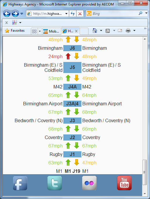
Highways Agency (England) Mobile Internet application
V-Traffic in France provides a sereis of Apps for traffic information. (See figure below). Separate Apps are available for the most popular mobile operating systems (Apple's iOS, Google's Android and Microsoft's Windows Phone).
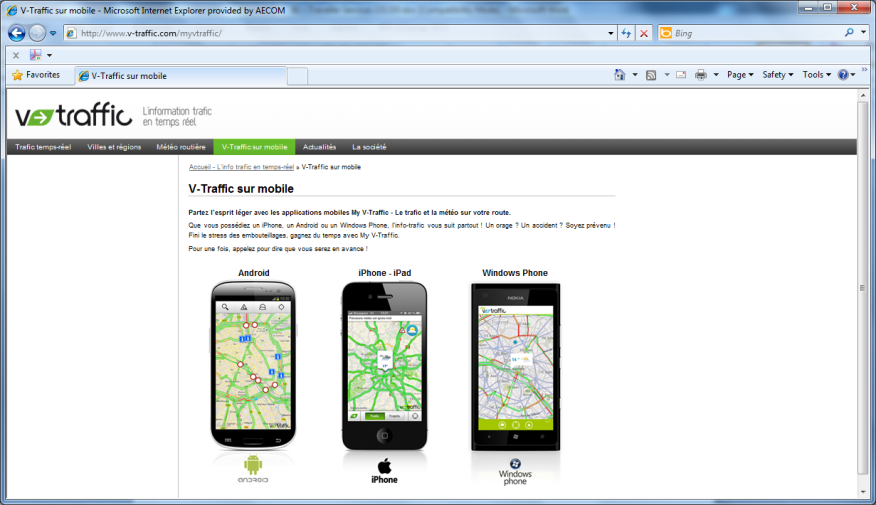
V-Traffic Mobile Applications
The key elements to consider in Traffic and Travel information app or mobile website must be:
Human interface design is critical in such applications and care must be taken to consider the menu structure to allow access to salient information as easily as possible. (See User Centred Design )
Multi-modal journey planning is also available via mobile apps and websites and increasingly applications that provide real time updates while en-route are found.
A good example is the Guardian Angel service provided in Münster Germany.
Mobile applications for Iphone, Android and Windows phone are provided and the application enables the user to plan their journey which seamlessly includes real time updates of public transport services. If service disruptions occur on route then the application will replan the trip on the fly and advise the user of revised service connections.
When specifying mobile internet sites and applications it is vital to ensure the mobile site(s) or application will operate on phones or tablet computers of the target audience. The most popular operating systems currently in use are:
Web Accessibility Standards for users with a disability should be considered in the design stage.
Many public transport operators now offer Wi-Fi internet access on their services. In addition, mobile coverage continues to improve across both urban and rural locations.
So-called “Big Data” has opened up a whole world of information which can be accessed on the move. A large number of service providers (such as Transport for London in the UK) provide access to their real-time data for applications and websites so that this may be utilised in a variety of methods. Google Transit and CityMapper use this data to provide an integrated service covering all aspects of a cities transport. Delays, incidents and other problems can be instantly reported and changes to pre-planned routes or an alternative, unaffected route can be suggested to the user.
However, there are also sources of data open to those without smartphones. A range of text services and .mobi sites enable all users to access some level of current real-time information on the running of the network, including such data as expected arrival time of buses, known delays to the network and roadworks or vehicles accidents which may cause problems for public transport and motorists alike.
Other applications or apps available utilising such data are numerous and offer a range of services for public transport users. One such example is Moovit, an Israel-based application company which has provided a system enabling users to report on the level of crowding on public transport services, in addition to other factors such as the cleanliness, comfort and (on a bus) the driver’s performance. Over the long-term, using these reports, a picture of which services are busiest (and should be avoided by the space-conscious commuter if possible) is built up and factored in. San Francisco’s BART system and the Netherlands’ Rail Network are utilising similar applications, with the Dutch using historic loading data to indicate the level of over-crowding on some trains.
This webpage is best read in conjunction with advice on use of radio and television for trip planning. (See TV & Radio )
En-route Traffic and Travel information delivered by Radio can be broken down into the following sub-groups:
Highway Advisory Radio are dedicated, usually local, radio stations broadcasting traffic and travel information and information on points of interest. Very often the traveller is advised of these services by the use of static signs next to the Highway network. Such services are common in the USA. In the USA these Traveller Information Systems are licenced by the Federal Communications Commission and are generally low power AM stations. Elsewhere they are also used in Japan along major motorways (AM). In Italy and France similar services operate (FM). In the UK (England), the Highways Agency has experimented with both low power AM Highway Advisory Radio services for specific major events and also a full internet radio service. However these services have now been discontinued.
Internet Radio traffic and travel specific services are also used. The UK’s Traffic Scotland service provides an Internet radio service covering Scotland with a looped travel information broadcast. A National (all Scotland) broadcast is updated every 20 minutes at peak times and every 30 minutes at off peak times and regional Scottish content is updated every 30 minutes at peak times and hourly at other times.
Highway Advisory Radio provides an effective way of informing motorists of problems on their current route where static signage informs the driver of the frequency they need to tune their receiver too. A research report from CalTrans in the USA presents technical information and insight into factors to consider when locating AM Highway Advisory Radio transmitters.
Traffic and Travel radio bulletins, as discussed in the pre-trip section provides tailored traffic information in short bursts within other programming. The level of detail provided and relevance will depend in part on the target audience and geographic coverage of the radio station. Necessarily the wider the radio station coverage area the more selective the incidents presented must be and therefore the classification and selection of the incidents for broadcast is significant.
Broadcasts are often focused on ‘Drive Time’ associated with commuter peaks. Incident information presented should be short and clear with some descriptive detail, some impact assessment and if possible, some resulting travel advice. The message should be broadly consistent with other information channel outputs.
A Dynamic Message Sign (DMS) – is any sign or graphics board that can change the message to the viewer (text or pictogram). It may be a Variable Message Sign (VMS) or a Changeable Message Sign (CMS) where:
Dynamic message signs – and more specifically changeable message signs – have been around for many years. Initially these often were conventional road signs with rotating prism elements within, where 3 options of message could be chosen. These allowed simple diversion route strategies to be implemented or warnings to be issued at known problem locations, however this type of sign is limited in what can be displayed and also needs careful maintenance to ensure rotating elements do not seize up.
Developments in technology then led to the available of magnetic flip disk (or flip dot) signs to be developed where a sign is made up of an array of disks with one black face and one yellow retro reflective face and passing a current through relevant disks can switch the face of the disk displayed. This type of sign uses very low power consumption, but can suffer from disks occasionally sticking and may not be as clearly visible as LED of Fibre Optic Signs depending on the lighting conditions. Fibre optic signs have a light source and fibre optic strands which illuminate pixels or a simple image.
The majority of roadside DMS are now LED as these are generally reliable and flexible in operation.
Changeable Message Signs are used when either a warning is to be given for a specific hazard or behaviour or when there are only a limited number of options available. A good example might be a speed activated warning sign associated with a bend in the road. The sign is illuminated if a vehicle approaches at high speed. These type of signs can be used to support road safety campaigns and can be very effective in reducing incidents are specific accident prone locations.
Variable Message Signs are used for a wider range of purposes including:
A useful synopsis of Active Traffic Management experiences in the USA and Europe can be found on the US DoT Federal Highway Administration website.
The size of the sign required is, in part dependent on the speed of traffic on the link in question. The faster the road speed the larger the sign needs to be to display the same amount of information. In addition, on high speed roads, the amount of information that can be assimilated in the available time is small. In the UK approximately seven words can be displayed on the largest VMS signs on motorways which are 3 line 18 character VMS.
Portable Dynamic Message Signs are particularly useful at locations where a permanent dynamic message sign is not justified. This may be during medium term roadworks, for a specific event, or perhaps on a motorway with significant seasonal traffic demand. Pre-planning of the location for such signs is vital in order to ensure they can be safely deployed and retrieved. Increasingly such signs are solar or wind powered and in locations where such signs are periodically deployed, provision of hardstanding for these signs should be considered.
In Europe there are technical standards for VMS design that must be followed. In addition there are guidelines for the Principles of VMS message design that provide more detail on how and when it is appropriate to use VMS.
Public Transport information is increasingly presented via digital media. These displays include summary screens showing:
Care needs to be taken when considering the information to be displayed. Use cases should be developed to inform the design of both the display and the information to be presented. As with kiosk design, the following factors need to be considered:
The UKs real time information group has several pertinent standards related to public transport information displays, for example "Meeting the Needs of Disabled Travellers" (See: RTIGPR003-D002-1.8).
Users of public transport services expect information on:
It is vital that the display technology provides trusted, accurate, reliable and understandable information. Pre-requisites for clear information include:
Additionally it is helpful to be able to advise the latest situation regarding service operation – real time information and information related to interchanging between services or modes.
Latest developments with public transport and multi-modal signage include increased use of solar powered displays and the use of e-ink and similar technologies to reduce the power consumption of signs. There is also greater use of TfT Liquid Chrystal display technology as opposed to LED technology which provides greater flexibility to present multiple types of information which can maximise value from the displays concerned.
Satellite Navigation Systems include a routing engine - software that plans the route to the destination. In basic models the route is planned on the basis of a fixed database that describes the road network. (See Basic Info-structure and Navigation and Positioning) More sophisitcated models can take into acount current traffic conditions and provide information on:
Presentation of the information on-screen or by audio must considered in light of human factors and the underlying map interface - the "user interface".(See Systems Approach to ITS Design).
Traffic information can be coded and distributed digitally as a non-audio data stream over radio. This is how most traffic-enabled Satellite Navigation Systems receive traffic information in real-time. They can then display an icon in relation to the event, alert the driver audibly to it and also prompt the driver to re-route - or automatically amend the route accordingly.
When there is a traffic incident, congestion, or extreme weather event, a data message can be sent to the navigation device. Each event can be assigned a level of severity (impact) in terms of its geographic extent, timing and its likely duration. (See Traffic Incidents) Transmitting these details enables the satellite navigation routing engine to calculate a delay level for the location (the links and junctions in the network that are affected). The software then recalulates the travel time and route options, taking account of this additional delay. Regulations and traffic restrictions may impact on whether automatic re-routing is allowed.
In Europe and North America the main standard for transmission of traffic event data to in vehicle satellite navigation systems is known as RDS-TMC. Information on RDS-TMC can be found from the Traveller Information Services Association website including TMC coverage maps. A lot of work has been undertaken to standardise the categorisation of events, inparticular the Alert C standard: ISO 14819:2013 - parts 1 and 2 define event categorisation for the RDS-TMC digital transmission system on FM radio.
For TMC to operate there must be a location code table tied to the underlying map network. These location code tables can be developed privately or publically.
Gradually as radio bandwidth becomes scarcer, so it is likely that Digital Audio Broadcasting DAB will take over from FM Analogue radio services.
There is a more detailed standard for broadcast of traffic related data over DAB known as TPEG. Practitioners should be mindful of the TPEG standard (ISO TS 18234) for traffic and public transport incident information. This standard makes use of the additional bandwidth available via DAB and the Internet. TPEG is now being widely implemented on digital networks. More information on TPEG can be found via the Traveller Information Services Association website and more specifically in the Introductory Guideline.
Both RDS-TMC and TPEG delivery mechanisms allow for the transmission of incident, congestion and weather related messages with TPEG allowing a much richer definition of incidents.
Both TPEG and RDS-TMC can be delivered as open or encypted services dependent on whether these services are to be provided by Government or the Private Sector.
Such information is of particular benefit to tourists and those who are unfamiliar with the route/public transport in question. This may help prioritise where these systems have greatest value. Such systems must be derive information on the stops on the route and must know when these stops have been reached. Most often they are linked to other on vehicle systems, such as ticket machines or automatic vehicle location systems. (See Passenger Transport) It is critically important to ensure robust operation of such systems making sure that they can be automatically updated if the vehicle is moved between routes. As with other display types, the following must be considered: